
Marion County, Iowa facts for kids
Quick facts for kids
Marion County
|
|
|---|---|

Marion County Courthouse in Knoxville
|
|

Location within the U.S. state of Iowa
|
|
 Iowa's location within the U.S. |
|
| Country | |
| State | |
| Founded | 1845 |
| Named for | Francis Marion |
| Seat | Knoxville |
| Largest city | Pella |
| Area | |
| • Total | 571 sq mi (1,480 km2) |
| • Land | 555 sq mi (1,440 km2) |
| • Water | 16 sq mi (40 km2) 2.8% |
| Population
(2020)
|
|
| • Total | 33,414 |
| • Density | 58.52/sq mi (22.594/km2) |
| Time zone | UTC−6 (Central) |
| • Summer (DST) | UTC−5 (CDT) |
| Congressional district | 2nd |
Marion County is a county in the U.S. state of Iowa. As of the 2020 census, the population was 33,414. The county seat is Knoxville. It is named for Francis Marion, a brigadier general from South Carolina in the American Revolutionary War.
Contents
Geography
According to the U.S. Census Bureau, the county has a total area of 571 square miles (1,480 km2), of which 555 square miles (1,440 km2) is land and 16 square miles (41 km2) (2.8%) is water.
Major highways
 Iowa Highway 5
 Iowa Highway 14
 Iowa Highway 92
 Iowa Highway 163
 Iowa Highway 316
Adjacent counties
- Jasper County (north)
- Mahaska County (east)
- Monroe County (southeast)
- Lucas County (southwest)
- Warren County (west)
Demographics
| Historical population | |||
|---|---|---|---|
| Census | Pop. | %± | |
| 1850 | 5,482 | — | |
| 1860 | 16,813 | 206.7% | |
| 1870 | 24,436 | 45.3% | |
| 1880 | 25,111 | 2.8% | |
| 1890 | 23,058 | −8.2% | |
| 1900 | 24,159 | 4.8% | |
| 1910 | 22,995 | −4.8% | |
| 1920 | 24,957 | 8.5% | |
| 1930 | 25,727 | 3.1% | |
| 1940 | 27,019 | 5.0% | |
| 1950 | 25,930 | −4.0% | |
| 1960 | 25,886 | −0.2% | |
| 1970 | 26,352 | 1.8% | |
| 1980 | 29,669 | 12.6% | |
| 1990 | 30,001 | 1.1% | |
| 2000 | 32,052 | 6.8% | |
| 2010 | 33,309 | 3.9% | |
| 2020 | 33,414 | 0.3% | |
| U.S. Decennial Census 1790-1960 1900-1990 1990-2000 2010-2018 |
|||

2020 census
The 2020 census recorded a population of 33,414 in the county, with a population density of 58.4743/sq mi (22.5771/km2). 96.24% of the population reported being of one race. 91.15% were non-Hispanic White, 0.87% were Black, 2.09% were Hispanic, 0.21% were Native American, 1.20% were Asian, 0.06% were Native Hawaiian or Pacific Islander and 4.41% were some other race or more than one race. There were 14,073 housing units, of which 13,145 were occupied.
2010 census
The 2010 census recorded a population of 33,309 in the county, with a population density of 60.1018/sq mi (23.2054/km2). There were 13,914 housing units, of which 12,723 were occupied.
Communities
Cities
Unincorporated communities
Population ranking
The population ranking of the following table is based on the 2010 census of Marion County.
† county seat
| Rank | City/Town/etc. | Municipal type | Population (2010 Census) |
|---|---|---|---|
| 1 | Pella | City | 10,352 |
| 2 | † Knoxville | City | 7,313 |
| 3 | Pleasantville | City | 1,694 |
| 4 | Melcher-Dallas | City | 1,288 |
| 5 | Bussey | City | 422 |
| 6 | Harvey | City | 235 |
| 7 | Hamilton | City | 130 |
| 8 | Swan | City | 72 |
| 9 | Marysville | City | 66 |
Gallery
-
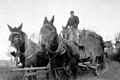
Marion County farmer with mule-drawn wagon, about 1926
-
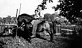
Two Iowa farm boys riding a pony, about 1937
-
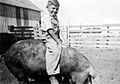
Iowa farm boy riding hog, about 1941
-
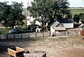
Farm house and barn yard near Pleasantville, 1957
-
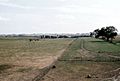
Cows in farm pasture, 1957
-

Farmer getting coal, December 1957
-
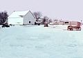
Farm barnyard
-
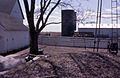
Farm barnyard and silo, 1960


Images for kids
-
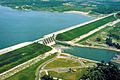
Red Rock Lake and Dam in Marion County near Pella. Elk Rock State Park is situated on both sides of the lake to the northwest. County road T15 crosses over the dam.

See also
 In Spanish: Condado de Marion (Iowa) para niños
