
Marmion Avenue facts for kids
Quick facts for kids Marmion AvenueWestern Australia |
|
|---|---|
 |
|
| General information | |
| Type | Highway |
| Length | 40.4 km (25 mi) |
| Opened | 1960s |
| Route number(s) | |
| Major junctions | |
| South end | |
|
|
| North end | Yanchep Beach Road, Yanchep |
| Location(s) | |
| Major suburbs | Karrinyup, Hillarys, Clarkson, Butler, Alkimos, Yanchep |
| Highway system | |
| Highways in Australia National Highway • Freeways in Australia Highways in Western Australia |
|
Marmion Avenue is a 40-kilometre (25 mi) arterial road in the northern coastal suburbs of Perth, Western Australia, linking Trigg in the south with Yanchep in the north. It forms part of State Route 71 along with West Coast Highway, which it joins onto at its southern terminus.
History

Marmion Avenue was first built as an arterial road that tracked the then-new outer northern suburbs of Perth, following the limit of the Perth metropolitan area as it expanded northwards. In the late 1960s, the road originally began at Beach Road in Marmion, giving the road its namesake.
Until the early 1980s, the road was a two-lane single carriageway connecting the coastal suburbs of Marmion and Mullaloo Beach. In 1984-85, the road was extended southwards to Karrinyup Road where it joined seamlessly onto West Coast Highway, which had been realigned further inland around the same time. Now the most important road in Perth's coastal suburbs, Marmion Avenue was duplicated up to Whitfords Avenue. In early 1986, it was assigned State Route 71, and from then on was gradually extended as a single carriageway road further north - extending first to Prendiville Avenue (just north of Ocean Reef Road), to Burns Beach Road in 1991 and to Quinns Road in the mid-1990s. Marmion Avenue was finally duplicated to its terminus in 2001, with the last portion being the empty stretch between Burns Beach Road & Quinns Rocks.
After delays due to disagreements at State Government level about what route the road should follow, Marmion Avenue was extended further north to Yanchep and opened to traffic in November 2008. The extension is currently a single carriageway, but earthworks have already been undertaken to enable conversion to dual carriageway at a later date. The extension also features roundabouts at future major junctions. The completion of this extension allowed the future satellite city of Alkimos/Eglinton to begin construction.
Future extensions
Extensions of Marmion Avenue are possible to Two Rocks. However, there are no plans for this at present – one possible complication would be Two Rocks's past use as a munitions dump, meaning that most non-suburban sections of the suburb are fenced off.
Major intersections
Marmion Avenue begins at the end of West Coast Highway at the Karrinyup Road intersection in Trigg, and currently ends at the coastal suburb of Yanchep and the Yanchep Beach Road roundabout. Almost all major intersections are controlled by traffic lights, with roundabouts more prevalent in the north, from Shenton Avenue onwards.

 Karrinyup Road (State Route 76 east / Tourist Drive 204 west), Trigg
 Reid Highway (State Route 3) east / North Beach Road west, North Beach and Carine
- Beach Road, Carine, Duncraig and Marmion
 Warwick Road (State Route 81), Duncraig and Sorrento
 Hepburn Avenue (State Route 82), Duncraig, Sorrento, Hillarys and Padbury
 Whitfords Avenue (State Route 83 east), Hillarys, Padbury, Kallaroo and Craigie
 Ocean Reef Road (State Route 84), Mullaloo, Beldon, Ocean Reef and Heathridge
- Hodges Drive, Ocean Reef, Heathridge and Connolly
- Shenton Avenue, Ocean Reef, Connolly, Iluka and Currambine
 Burns Beach Road (State Route 87), Iluka, Currambine, Burns Beach and Kinross
- Neerabup Road/Anchorage Drive, Mindarie and Clarkson
- Hester Avenue/Anchorage Drive North, Mindarie, Clarkson and Merriwa
- Quinns Road, Quinns Rocks and Mindarie
- Jindalee Boulevard/Kingsbridge Boulevard, Jindalee and Butler
Gallery
-
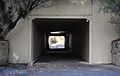
An underpass below Marmion Avenue, near Whitfords Avenue
-
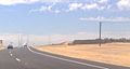
New, single-lane extension of Marmion Avenue opened in 2008, heading north in the currently undeveloped suburb of Alkimos
-
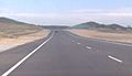
New, single-lane extension of Marmion Avenue opened in 2008, heading north in the currently undeveloped suburb of Eglinton


