
Marsfield, New South Wales facts for kids
Quick facts for kids MarsfieldSydney, New South Wales |
|||||||||||||||
|---|---|---|---|---|---|---|---|---|---|---|---|---|---|---|---|

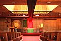
Curzon Hall on Agincourt Road, built in 1898
|
|||||||||||||||
| Population | 13,297 (2016 census) | ||||||||||||||
| • Density | 3,445/km2 (8,920/sq mi) | ||||||||||||||
| Postcode(s) | 2122 | ||||||||||||||
| Area | 3.86 km2 (1.5 sq mi) | ||||||||||||||
| Location | 16 km (10 mi) north-west of Sydney CBD | ||||||||||||||
| LGA(s) | City of Ryde | ||||||||||||||
| State electorate(s) | Ryde | ||||||||||||||
| Federal Division(s) | Bennelong | ||||||||||||||
|
|||||||||||||||
Marsfield is a suburb on the Upper North Shore of Sydney, in the state of New South Wales, Australia. Marsfield is located 16 kilometres north-west of the Sydney central business district in the local government area of the City of Ryde.
The suburb is noted for its proximity to a number of leading scientific and tertiary educational institutions such as CSIRO, Macquarie University, the Macquarie Park Business Park and Macquarie University Hospital.
Contents
History
The suburb's name is derived from Field of Mars, the original name in the early days of British colonisation of Australia, given to the area by Governor Phillip in 1792 .
Aboriginal culture
The whole area between the Parramatta and Lane Cove Rivers was originally known by its Aboriginal name Wallumatta. The aboriginal name survives in a local park, the Wallumatta Nature Reserve, located at the corner of Twin and Cressy Roads, North Ryde.
European settlement
In 1792 Governor Phillip began the granting of parcels of lands to Royal Marines, and the area was referred to on Phillip's maps as the Field of Mars, named after the Roman Field of Mars probably because of the military link. The area was later part of the suburb of North Ryde, and many consider that Marsfield is still a part of the greater North Ryde area. Field of Mars was also the name for the parish proclaimed in 1835.
In 1874, following extensive debate including a Parliamentary Select Committee, the government resumed the Common for sale and settlement by small farmers, using the money to fund bridges across the Parramatta River at Gladesville and Iron Cove. The land was subdivided into small farms of between 0.4 and 1.6 ha (1–4 acres), and released for sale in stages, starting in 1885.
Many of the streets in Marsfield and bordering suburbs, mainly Eastwood and Macquarie Park, are named after famous historical conflicts or battles, such as Abuklea Road, Agincourt Road, Alma Road, Balaclava Road, Buffalo Road (Gladesville), Busaco Road, Corunna Road, Cressy Road (East Ryde), Crimea Road, Culloden Road, Fontenoy Road, Khartoum Road, Plassey Road, Talavera Road, Taranto Road, Torrington Road, Trafalgar Place, Vimiera Road, Waterloo Road.
In 1894, the "Municipality of Marsfield" formed its own local government, splitting from Ryde Municipality.
Stately, historical Curzon Hall was built in the 1890s by Harry Smith and named after his wife Isabella Curzon-Smith. The house was bought in 1921 by the Society of Saint Vincent de Paul which established St Joseph's Seminary on the premises. It now serves as a function centre.
Until the 1950s, substantial parts of the North Ryde/Marsfield area were part of the "Green Belt" which prevented building houses on lots of less than 2 ha (5 acres). The Marsfield-North Ryde Green Belt boundaries were revised and in December 1959, 688 ha (1,700 acres) of land was rezoned. The last Green Belt land was released in September 1969 to build Macquarie Shopping Centre and Macquarie University.
Boundaries
Marsfield is bounded by the Lane Cove River, Macquarie University Sports Fields, Talavera Road, Culloden Road, Waterloo Road, Vimiera Road, Marsfield Park and Culloden Road in the north, Epping Road, Shrimptons Creek, Kent Road, Ruse Street and Shrimptons Creek in the east, Bridge Road and Abuklea Road in the south and Terrys Creek in the west.
Landmarks and institutions

Marsfield is home to:
- Curzon Hall, 53 Agincourt Rd (built 1898 by businessman Harry Smith), a large castle-like manor in neo-Romanesque style, now turned restaurant/function centre
- Marsfield Community Church, 58-60 Agincourt Rd (established in 1933, current building opened on September 21, 1940).
- Epping Boys High School;
- Commonwealth Scientific and Industrial Research Organisation (CSIRO)[1].
- Radio Physics Laboratory.
- Information Communication Technology (ICT) Centre, and
- Headquarters for the
- Australia Telescope National Facility, and
- Anglo-Australian Observatory.
Public transport
A number of bus routes service Marsfield. The 292/293 routes run from the city through Lane Cove and terminate in Busaco Road while many other routes e.g. 288/291 travel along Epping Road to Epping station.
Macquarie University railway station is located on Herring Road between the university and Macquarie shopping centre.
Demographics
At the 2016 census, Marsfield recorded a population of 13,297. Of these:
Images for kids
-
St Anthony's Catholic Church, Agincourt Road
-

Accommodation for Macquarie University students


See also
 In Spanish: Marsfield para niños
