
Martha's Vineyard Airport facts for kids
Quick facts for kids
Marthas Vineyard Airport
|
|||||||||||||||
|---|---|---|---|---|---|---|---|---|---|---|---|---|---|---|---|
| Summary | |||||||||||||||
| Airport type | Public | ||||||||||||||
| Owner | Dukes County | ||||||||||||||
| Operator | Martha's Vineyard Airport Commission | ||||||||||||||
| Serves | Dukes County, Massachusetts | ||||||||||||||
| Location | Vineyard Haven, Massachusetts | ||||||||||||||
| Focus city for | Cape Air | ||||||||||||||
| Elevation AMSL | 67 ft / 20 m | ||||||||||||||
| Coordinates | 41°23′35″N 070°36′52″W / 41.39306°N 70.61444°W | ||||||||||||||
| Website | MVYairport.com | ||||||||||||||
| Maps | |||||||||||||||
 FAA airport diagram |
|||||||||||||||

MVY
Location in Massachusetts

MVY
Location in the United States
|
|||||||||||||||
| Runway | |||||||||||||||
|
|||||||||||||||
| Statistics (2017) | |||||||||||||||
|
|||||||||||||||
|
Source: Federal Aviation Administration
|
|||||||||||||||
Martha's Vineyard Airport (IATA: MVY, ICAO: KMVY, FAA LID: MVY) is a public airport located in the middle of the island of Martha's Vineyard, three miles (5 km) south of the central business district of Vineyard Haven, in Dukes County, Massachusetts, United States. This airport is owned by Dukes County and lies on the border between the towns of West Tisbury and Edgartown.
It is the largest of three airports on the island. It is the only airport on the island served by airlines. In addition to service from four commercial airlines, it is used by a significant number of general aviation aircraft. The other airports on the Island are Katama Airpark and Trade Wind Airport.
The airport identifier MVY has entered into general use as an abbreviation for the island of Martha's Vineyard, and is often used in non-aviation purposes.
Contents
Overview
Martha's Vineyard Airport covers an area of 688 acres (278 ha) which contains two runways: 6/24 measuring 5,504 x 100 ft (1,678 x 30 m) and 15/33 measuring 3,297 x 75 ft (1,005 x 23 m).
For 12-month period ending March 31, 2017, the airport had 40,555 aircraft operations, an average of 111 per day: 53% general aviation, 43% air taxi, 3% commercial, and <1% military. In November 2017, there were 72 aircraft based at this airport: 59 single engine, 12 multi-engine, and 1 helicopter.
Terminal and facilities
The terminal has a restaurant, passenger holding areas, check-in desks and a small luggage claim. The ramp has the ability to hold up to 50 aircraft with about 15 spots reserved for commercial aviation. The air traffic control tower is open from 6:00 am to 10:00 pm.
Operations
Along with the TSA, the West Tisbury Police Department is in charge of the security of the airport, and the ARFF department is staffed by 10 full-time firefighters. The airport currently operates several fully functional emergency response vehicles.
History
.jpg)
The airfield was built in 1942 as Naval Auxiliary Air Facility Martha's Vineyard (NAAF Martha's Vineyard) to support training of naval aviators prior to their deployment to aircraft carriers in the Pacific Theater. Thousands of men received six weeks of intensive training there. The installation was renamed as Naval Auxiliary Air Station Martha's Vineyard in 1945, placed in caretaker status in 1946, and ultimately transferred to Dukes County in 1959.
Northeast Airlines served Martha's Vineyard beginning in August 1944, when it acquired Mayflower Airlines. By the 1950s it was the dominant airline at the airport. Air New England served MVY from the 1970s until 1981; Provincetown-Boston Airline (PBA), operating as a feeder for Eastern Airlines, served MVY in the 1980s. Bridgeport-based Atlantic Air served MVY in the mid-1980s before merging into Business Express Airlines, which continued service to MVY under the Delta Connection brand.
Other historical carriers at MVY included Bar Harbor Airlines, Brockway Air, Catskill Airways, Edgartown Air, Executive Airlines, Express Air, Gull Air, Holiday Airlines, Island Airlines, New Haven Airlines, New York Air, NorEast, Northern Airlines, Spectrum Airlines and Trans East Airlines.
The new terminal building, constructed in 2001, replaced an older wooden structure that was the original base operations building. Historical photos and memorabilia are mounted on the western wall of the main hall, near the entrance to the restaurant, and tell the story of the Navy squadrons posted there during the war.
Airlines and destinations
| Airlines | Destinations |
|---|---|
| American Eagle | Seasonal: Charlotte, New York–LaGuardia, Philadelphia, Washington–National |
| Cape Air | Boston, Nantucket, New Bedford Seasonal: Hyannis, New York–JFK, White Plains |
| Delta Connection | Seasonal: New York-JFK (resumes May 28, 2021), New York–LaGuardia |
| JetBlue | Seasonal: Boston, Newark (begins July 1, 2021), New York–JFK, New York-LaGuardia (begins July 1, 2021), Washington–National |
| Tradewind Aviation | Seasonal charter: Teterboro, White Plains |
| Domestic destinations map |
|---|
Statistics
Top destinations
| Rank | Airport | Passengers | Carriers |
|---|---|---|---|
| 1 | Boston, Massachusetts | 19,410 | Cape Air, JetBlue |
| 2 | New York–JFK, New York | 15,270 | Cape Air, JetBlue |
| 3 | New York–LaGuardia, New York | 6,920 | American Eagle, Delta Connection |
| 4 | Washington–National, D.C. | 6,160 | American Eagle, JetBlue |
| 5 | White Plains, New York | 1,750 | Cape Air, Tradewind |
| 6 | Nantucket, Massachusetts | 1,200 | Cape Air |
| 7 | Hyannis, Massachusetts | 450 | Cape Air |
| 8 | New Bedford, Massachusetts | 210 | Cape Air |
- FAA Airport Diagram (PDF), effective 15 December 2011
- Resources for this airport:
- AirNav airport information for KMVY
- ASN accident history for MVY
- FlightAware airport information and live flight tracker
- NOAA/NWS latest weather observations
- SkyVector aeronautical chart for KMVY
- FAA current MVY delay information
Images for kids
-
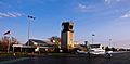
Cape Air plane at Martha's Vineyard Airport ramp in 2001
-
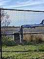
JetBlue ERJ-190 taxing to gate 2 at MVY
-
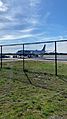
JetBlue ERJ-190 at the Commercial Ramp
-
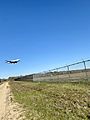
JetBlue ERJ-190 landing at MVY from Washington-National Airport


See also
 In Spanish: Aeropuerto de Martha's Vineyard para niños
