
Matterhorn facts for kids
Quick facts for kids Cervino - Matterhorn |
|
|---|---|

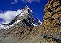
The Matterhorn, seen from Zermatt
|
|
| Highest point | |
| Elevation | 4,478 metres (14,693 feet) |
| Prominence | 1,029 m |
| Geography | |
| Location | |
| Parent range | Pennine Alps |
| Climbing | |
| First ascent | 14 July 1865 by Edward Whymper and party |
| Easiest route | Hörnli ridge (AD, rock/mixed climb) |
The Matterhorn (in German; Italian: Cervino, French: Mont Cervin or Le Cervin) is perhaps the most familiar mountain in the European Alps. Its height is 4,478 metres.
The mountain is on the border between Switzerland and Italy, it towers over the Swiss village of Zermatt and the Italian village Breuil-Cervinia in the Val Tournanche. The name of the mountain comes from the German words Matte, meaning valley or meadow, and Horn, which means peak.
Contents
Height

The Matterhorn has two distinct summits, situated at either end of a 100-metre-long (330 ft) exposed rocky crest which forms the Italian/Swiss border. In August 1792, the Genevan geologist and explorer Horace Bénédict de Saussure made the first measurement of the Matterhorn's height, using a sextant and a 50-foot-long (15 m) chain spread out on the Theodul glacier. He calculated its height as 4,501.7 m (14,769 ft). In 1868 the Italian engineer Felice Giordano measured a height of 4,505 m (14,780 ft) by means of a mercury barometer, which he had taken to the summit. The Dufour map, which was afterwards followed by the Italian surveyors, gave 4,482 m (14,705 ft) as the height of the Swiss summit.
In 1999, the summit height was precisely determined to be at 4,477.54 m (14,690 ft) above sea level by using Global Positioning System technology as part of the TOWER Project (Top of the World Elevations Remeasurement) and to an accuracy of less than one centimetre, which allows future changes to be tracked.
The topographic prominence of the Matterhorn is 1,042 metres (3,419 ft) as the ridge connecting it with a higher summit (in this case the Weisshorn, which is the culminating point of the range west of the Mattertal valley) sinks to a height of 3,436 m (11,273 ft) at the Col Durand, a saddle between the Pointe de Zinal and the Mont Durand. The topographic isolation is 13.9 km (8.6 mi), as the nearest point of higher elevation is the one-metre (3 ft 3 in) higher Western Liskamm.
Considering mountains with a topographic prominence of at least 300 m (980 ft), the Matterhorn is the sixth-highest summit in the Alps and Europe outside the Caucasus Mountains. It is the fifth-highest summit of Valais and Switzerland and the third highest summit of the Aosta Valley and Italy. Locally, it is the third-highest summit in the municipality of Zermatt and the highest summit in the municipality of Valtournenche. On the official International Climbing and Mountaineering Federation list of Alpine four-thousanders, which also includes subsidiary summits of higher mountains such as the nearby Monte Rosa, the Matterhorn is the 12th highest summit in the Alps.
| 1792 (Saussure's Travels in the Alps) | 1862 (Dufour Map) | 1868 (Giordano) | 1880 (Siegfried Map) | 1934 (S. M.) | 1946 (National Map) | 1999 (TOWER) | 2010 (N. M.) |
|---|---|---|---|---|---|---|---|
| 4,501.7 m (2309.75 T) |
4,482 m | 4,505 m | 4,482 m | 4,481 m | 4,477.5 m | 4,477.54 m | 4,478 m |
Geography

The Matterhorn has a pyramidal shape with four faces nearly facing the four compass points. Three of them (north, east and west) are on the Swiss side of the border and watershed (Mattertal valley) and one of them (south) is on the Italian side of the border (Valtournenche valley). The north face overlooks the Ober Gabelhorn (7 km away) across the Zmutt Glacier and valley (above Zermatt), the east face overlooks the Gorner Glacier system between the Gornergrat and Monte Rosa (respectively 10 and 17 km away) across the Theodul Pass, the west face overlooks the upper basin of the Zmutt Glacier between the Dent Blanche and the Dent d'Hérens (respectively 7 and 4 km away) and the south face fronts the resort town of Breuil-Cervinia and overlooks a good portion of the Valtournenche. The Matterhorn does not form a perfect square pyramid, as the north and south faces are wider than the west and east faces. Moreover, the latter faces do not actually meet on the summit but are connected by a 100-metre-long horizontal west–east ridge between the north and south faces.
The Matterhorn's faces are steep, and only small patches of snow and ice cling to them; regular avalanches send the snow down to accumulate on the glaciers at the base of each face, the largest of which are the Tiefmattengletscher to the west, part of the Zmutt Glacier, and the Matterhorn Glacier to the north. Smaller glaciers lie at the base of the south face (the Lower Matterhorn Glacier) and the east face (unnamed). In this area, the border between Switzerland and Italy coincides with the main Alpine watershed, separating the drainage basin of the Rhone on the north (Mediterranean Sea) and that of the Po on the south (Adriatic Sea). The north side is drained by the Zmuttbach (west and north faces) and the Gornera through the Furggbach (east face), tributaries of the Rhone through the (Matter) Vispa. The south side and face is drained by the Marmore torrent, tributary of the Po through the Dora Baltea (or Doire baltée). The Theodul Pass, located on the watershed between the Matterhorn and the Breithorn, at 3,295 metres, is the easiest passage between the two valleys and countries (the slightly lower Furggjoch not being used as a pass). The pass was used as a crossover and trade route for the Romans and the Romanised Celtic population Salassi between 100 BCE and 400 CE. The area is now heavily glaciated and covered on the north side by the Theodul Glacier.
Well-known faces are the east and north, visible from the area of Zermatt, although mostly hidden from the Mattertal by the chain of the Weisshorn. The east face is 1,000 metres high and, because it is "a long, monotonous slope of rotten rocks", presents a high risk of rockfall, making its ascent dangerous. The north face is 1,200 metres high and is one of the most dangerous north faces in the Alps, in particular for its risk of rockfall and storms. The south face, well visible from the Valtournenche, is 1,350 metres high and offers many different routes. The west face, the highest at 1,400 metres, has the fewest ascent routes and lies in a more remote area than the other faces.
The four main ridges separating the four faces are the main climbing routes. The least difficult technical climb and the usual climbing route, the Hörnli ridge (Hörnligrat), lies between the east and north faces and is aligned towards the Oberrothorn above Zermatt. To its west lies the Zmutt ridge (Zmuttgrat), between the north and west faces and aligned towards the Wandfluehorn; this is, according to Collomb, "the classic route up the mountain, its longest ridge, also the most disjointed." The Lion ridge (Cresta del Leone / Arête du lion), lying between the south and west faces and aligned towards the Dent d'Hérens is the Italian normal route and goes across Pic Tyndall; Collomb comments, "A superb rock ridge, the shortest on the mountain, now draped with many fixed ropes, but a far superior climb compared with the Hörnli." Finally the south side is separated from the east side by the Furggen ridge (Furggengrat), which is aligned towards the Klein Matterhorn. It is, according to Collomb, "the hardest of the ridges [...] the ridge still has an awesome reputation but is not too difficult in good conditions by the indirect finish".
While the Matterhorn is the culminating point of the Valtournenche on the south, it is only one of the many 4000 metres summits of the Mattertal valley on the north. Its height is exceeded by four major summits: the Weisshorn (4,505 m), the Dom (4,545 m), the Liskamm (4,527 m) and the second highest in the Alps, Monte Rosa (4,634 m). This section of the Pennine Alps, including the Matterhorn, the Zinalrothorn, the Dent Blanche, the Dent d'Hérens, the Breithorn, the Strahlhorn, the Rimpfischhorn and the Alphubel, concentrates most of western Europe's highest mountains and forms a crown of peaks around Zermatt. The deeply glaciated region between the Matterhorn and Monte Rosa (named Dent Blanche-Matterhorn-Monte Rosa) is listed in the Federal Inventory of Landscapes and Natural Monuments since 1983.


Weather
The Matterhorn is an isolated mountain. Because of its position on the main Alpine watershed and its great height, the Matterhorn is exposed to rapid weather changes. In addition, the steep faces of the mountain and its isolated location make it prone to banner clouds formation, with the air flowing around the mountain producing condensation of the air on the lee side and also creating vortices.
Geology
Apart from the base of the mountain, the Matterhorn is composed of gneiss belonging to the Dent Blanche klippe, an isolated part of the Austroalpine nappes, lying over the Penninic nappes. The Austroalpine nappes are part of the Apulian plate, a small continent which broke up from Africa before the Alpine orogeny. For this reason the Matterhorn has been popularized as an African mountain. The Austroalpine nappes are mostly common in the Eastern Alps.
The Swiss explorer and geologist Horace-Bénédict de Saussure, inspired by the view of the Matterhorn, anticipated the modern theories of geology:
What power must have been required to shatter and to sweep away the missing parts of this pyramid; for we do not see it surrounded by heaps of fragments; one only sees other peaks - themselves rooted to the ground - whose sides, equally rent, indicate an immense mass of débris, of which we do not see any trace in the neighbourhood. Doubtless this is that débris which, in the form of pebbles, boulders, and sand, fills our valleys and our plains.
Formation

The formation of the Matterhorn (and the whole Alpine range) started with the break-up of the Pangaea continent 200 million years ago into Laurasia (containing Europe) and Gondwana (containing Africa). While the rocks constituting the nearby Monte Rosa remained in Laurasia, the rocks constituting the Matterhorn found themselves in Gondwana, separated by the newly formed Tethys Ocean.
100 million years ago the extension of the Tethys Ocean stopped and the Apulian plate broke from Gondwana and moved toward the European continent. This resulted in the closure of the western Tethys by subduction under the Apulian plate (with the Piemont-Liguria Ocean first and Valais Ocean later). The subduction of the oceanic crust left traces still visible today at the base of the Matterhorn (accretionary prism). The orogeny itself began after the end of the oceanic subduction when the European continental crust collided with the Apulian continent, resulting in the formation of nappes. The Matterhorn acquired its characteristic pyramidal shape in much more recent times as it was caused by natural erosion over the past million years. At the beginning of alpine orogeny, the Matterhorn was only a rounded mountain like a hill. Because its height is above the snowline, its flanks are covered by ice, resulting from the accumulation and compaction of snow. During the warmer period of summer, part of the ice melts and seeps into the bedrock. When it freezes again, it fractures pieces of rock because of its dilatation (freeze-thaw), forming a cirque. Four cirques led to the shape of the mountain. Because of its recognizable shape, many other similar mountains around the world were named or nicknamed the 'Matterhorn' of their respective countries or mountain ranges.
Rocks
Most of the base of the mountain lies in the Tsaté nappe, a remnant of the Piedmont-Liguria oceanic crust (ophiolites) and its sedimentary rocks. Up to 3,400 metres the mountain is composed of successive layers of ophiolites and sedimentary rocks. From 3,400 metres to the top, the rocks are gneisses from the Dent Blanche nappe (Austroalpine nappes). They are divided into the Arolla series (below 4,200 m) and the Valpelline zone (the summit). Other mountains in the region (Weisshorn, Zinalrothorn, Dent Blanche, Mont Collon) also belong to the Dent Blanche nappe.
Tourism and trekking
Since the eighteenth century the Alps have attracted more and more people and fascinated generations of explorers and climbers. The Matterhorn remained relatively little known until 1865, but the successful ascent followed by the tragic accident of the expedition led by Edward Whymper caused a rush on the mountains surrounding Zermatt.
The construction of the railway linking the village of Zermatt from the town of Visp started in 1888. The first train reached Zermatt on July 18, 1891 and the entire line was electrified in 1930. Since 1930 the village is directly connected to St. Moritz by the Glacier Express panoramic train. However there is no connection with the village of Breuil-Cervinia on the Italian side. Travellers have to hire mountain guides to cross the 3,300 metres high glaciated Theodul Pass, separating the two resorts. The town of Zermatt remains almost completely free of internal combustion vehicles and can be reached by train only. (Apart from the local police service which uses a Volkswagen car, only electric vehicles are used locally).

Rail and cable-car facilities have been built to make some of the summits in the area more accessible. The Gornergrat railway, reaching a record altitude of 3,100 metres, was inaugurated in 1898. Areas served by cable car are the Unterrothorn and the Klein Matterhorn (Little Matterhorn) (3,883 m, highest transportation system in Europe). The Hörnli Hut (3,260 m), which is the start of the normal route via the Hörnli ridge, is easily accessible from Schwarzsee (2,600 m) and is also frequented by hikers. The Zermatt and Breuil-Cervinia resorts function as separate ski resort all year round and are connected by skilifts over the Theodul Pass. In 2015 it was expected that there would be constructed a cable car link between Testa Grigia (or Tête grise) and Klein Matterhorn. It will finally provide a link between the Swiss and Italian side of the Matterhorn.
The Matterhorn Museum (Zermatt) relates the general history of the region from alpinism to tourism. In the museum, which is in the form of a reconstituted mountain village, the visitors can relive the first and tragic ascent of the Matterhorn and see the objects having belonged to the protagonists.
The Tour of the Matterhorn can be effected by trekkers in about 10 days. Considered by some as one of the most beautiful treks in the Alps, it follows many ancient trails that have linked the Swiss and Italian valleys for centuries. The circuit includes alpine meadows, balcony trails, larch forests and glacial crossings. It connects six valleys embracing three different cultures: the German-speaking high Valais, the French-speaking central Valais and the bilingual French/Italian-speaking Aosta Valley. Good conditions are necessary to circumnavigate the peak. After reaching Zinal from Zermatt by the Augstbord and Meiden passes, the trekker crosses the Col de Sorebois and the Col de Torrent before arriving at Arolla. Then the Arolla Glacier and the Col Collon must be crossed on the way to Prarayer, followed by the Col de Valcournera to Breuil-Cervinia. In the last and highest section, the Theodul Pass must be crossed before returning to Zermatt. In total, seven passes between 2,800 and 3,300 metres must be crossed on a relatively difficult terrain.
As of 2015 almost two million visitors arrive at Zermatt annually. An average of around twelve people per year have died on Matterhorn in the ten years from 2005 to 2015.
Images for kids
-
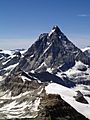
View on the south and east faces and the area of the Theodul Pass between Italy (left) and Switzerland (right)
-
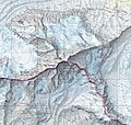
The Matterhorn on the National Map of Switzerland
-
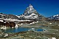
View on the east face with alpine lake
-
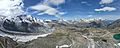
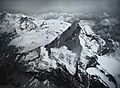
Aerial panorama of the Matterhorn from the Gornergrat 170622
-
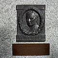
Plaque on the front wall of the Monte Rosa Hotel, commemorating the first ascent by Edward Whymper
-
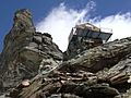
The Carrel Hut (3,830 m) on the Lion ridge
-
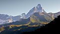
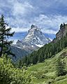
The Matterhorn seen from the Valtournenche Valley
-
The first ascent of the Matterhorn, by Gustave Doré
-
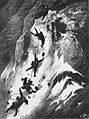
The first descent of the Matterhorn, by Gustave Doré
-
South-west side of the Matterhorn (Tyndall shoulder on the foreground)
-
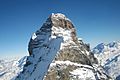
The north and east faces of the Matterhorn.
-
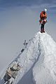
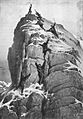
A climber standing on the summit.
-
Trail to the Hörnli Hut
-
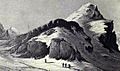
Theodulpass, c. 1800
-
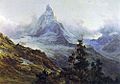
The Matterhorn by Edward Theodore Compton, 1879
-
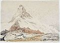
The Matterhorn by John Ruskin, 1849
-
Aerial photography by Eduard Spelterini in 1910


See also
 In Spanish: Cervino para niños
