Mauldin, South Carolina facts for kids
Quick facts for kids
Mauldin, South Carolina
|
|
|---|---|

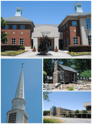
Top, left to right: Mauldin City Hall, Mauldin United Methodist Church, Mauldin Cultural Center, Mauldin High School
|
|

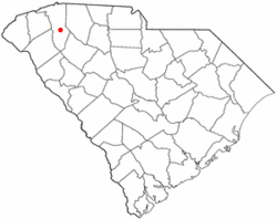
Location of Mauldin, South Carolina
|
|
| Country | United States |
| State | South Carolina |
| County | Greenville |
| Area | |
| • Total | 11.91 sq mi (30.84 km2) |
| • Land | 11.84 sq mi (30.67 km2) |
| • Water | 0.06 sq mi (0.16 km2) |
| Elevation | 942 ft (287 m) |
| Population
(2010)
|
|
| • Total | 22,889 |
| • Estimate
(2019)
|
25,409 |
| • Density | 2,145.67/sq mi (828.44/km2) |
| Time zone | UTC-5 (Eastern (EST)) |
| • Summer (DST) | UTC-4 (EDT) |
| ZIP code |
29662
|
| Area code(s) | 864 |
| FIPS code | 45-45115 |
| GNIS feature ID | 1246563 |
Mauldin is a city in Greenville County, South Carolina, United States. The population was 15,224 at the 2000 census, 22,889 in 2010, and an estimated 25,409 in 2019. It is a principal city of the Greenville-Anderson-Mauldin Metropolitan Statistical Area.
Contents
Geography
Mauldin is located south of the center of Greenville County, between the city of Greenville to the northwest and Simpsonville to the southeast. According to the United States Census Bureau, the city has a total area of 10.0 square miles (25.9 km2), of which 0.04 square miles (0.1 km2), or 0.46%, are water.
U.S. Route 276 (Main Street) passes through the center of Mauldin, leading northwest 8 miles (13 km) to the center of Greenville and southeast 5 miles (8 km) to Simpsonville. Interstate 385 runs through the eastern side of Mauldin, leading north to Interstate 85 on the east side of Greenville. I-385 connects with Interstate 185 on the southern edge of Mauldin, and I-185 continues west and northwest 13 miles (21 km) to join I-85 on the southwest side of Greenville. From its interchange with I-185, I-385 leads southeast 30 miles (48 km) to Interstate 26 near Clinton.
History
Benjamin Griffith was awarded the first land grant in what is now called Mauldin in 1784. The name of Mauldin was given to the town almost accidentally in 1820 thanks to South Carolina's lieutenant governor, W. L. Mauldin. The train station was called "Mauldin" because the lieutenant governor had assisted in getting the Greenville Laurens Railroad Company to come through the village. Over time, the entire area took the name of Mauldin.
During the Civil War, many of Mauldin's citizens left to fight, and the city virtually dried up. It never completely recovered until after World War II when the community was incorporated as a town (1960).
Demographics
| Historical population | |||
|---|---|---|---|
| Census | Pop. | %± | |
| 1960 | 1,462 | — | |
| 1970 | 3,797 | 159.7% | |
| 1980 | 8,143 | 114.5% | |
| 1990 | 11,587 | 42.3% | |
| 2000 | 15,224 | 31.4% | |
| 2010 | 22,889 | 50.3% | |
| 2019 (est.) | 25,409 | 11.0% | |
| U.S. Decennial Census | |||
2020 census
| Race | Num. | Perc. |
|---|---|---|
| White (non-Hispanic) | 14,551 | 58.85% |
| Black or African American (non-Hispanic) | 5,821 | 23.54% |
| Native American | 36 | 0.15% |
| Asian | 802 | 3.24% |
| Pacific Islander | 42 | 0.17% |
| Other/Mixed | 1,115 | 4.51% |
| Hispanic or Latino | 2,357 | 9.53% |
As of the 2020 United States census, there were 24,724 people, 9,968 households, and 6,339 families residing in the city.
School
Greenville County School District operates public schools. The only high school is Mauldin High School.
Economy
The supermarket chain BI-LO was founded in Mauldin and had its headquarters there until 2011.
Education
Public education in Mauldin is administered by Greenville County School District. The district operates Mauldin High School.
Mauldin has a public library, a branch of the Greenville County Library System.
Notable people
- Kevin Garnett, Olympian, professional basketball player
- Orlando Jones, actor
- Al Yeargin, professional baseball player
- Grant Cable, music producer
- Vibe Merchant, vibe supplier
See also
 In Spanish: Mauldin para niños


