Mauston, Wisconsin facts for kids
Quick facts for kids
Mauston, Wisconsin
|
|
|---|---|

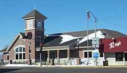
Mauston Library
|
|

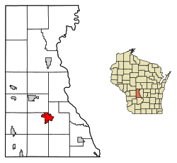
Location of Mauston in Juneau County, Wisconsin
|
|
| Country | United States |
| State | Wisconsin |
| County | Juneau |
| Area | |
| • Total | 4.89 sq mi (12.67 km2) |
| • Land | 4.47 sq mi (11.57 km2) |
| • Water | 0.43 sq mi (1.10 km2) |
| Elevation | 883 ft (269 m) |
| Population
(2010)
|
|
| • Total | 4,423 |
| • Estimate
(2019)
|
4,355 |
| • Density | 974.71/sq mi (376.37/km2) |
| Time zone | UTC-6 (Central (CST)) |
| • Summer (DST) | UTC-5 (CDT) |
| Zip Code |
53948
|
| Area code(s) | 608 |
| FIPS code | 55-50025 |
| GNIS feature ID | 1569135 |
Mauston is a city in and the county seat of Juneau County, Wisconsin, United States. The population was 4,411 as of the 2010 census. It is approximately 70 miles northwest from the state capital, Madison.
Contents
History
Mauston was founded by Milton M. Maughs. The town was originally named Maughs Town after Maughs. The town's beginning was based on the lumber industry of early Wisconsin. The history of Mauston is currently preserved in the Boorman House on Union Street.
Geography
Mauston is located at 43°48′N 90°5′W / 43.800°N 90.083°W (43.798, -90.077). It is in the Central Standard time zone. Elevation is 883 feet.
According to the United States Census Bureau, the city has a total area of 4.79 square miles (12.41 km2), of which, 4.39 square miles (11.37 km2) is land and 0.40 square miles (1.04 km2) is water.
Airport
Mauston is serviced by the Mauston-New Lisbon Union Airport (82C). The airport is joint owned with New Lisbon.
Demographics
| Historical population | |||
|---|---|---|---|
| Census | Pop. | %± | |
| 1870 | 952 | — | |
| 1880 | 1,013 | 6.4% | |
| 1890 | 1,343 | 32.6% | |
| 1900 | 1,718 | 27.9% | |
| 1910 | 1,701 | −1.0% | |
| 1920 | 1,966 | 15.6% | |
| 1930 | 2,107 | 7.2% | |
| 1940 | 2,621 | 24.4% | |
| 1950 | 3,171 | 21.0% | |
| 1960 | 3,531 | 11.4% | |
| 1970 | 3,466 | −1.8% | |
| 1980 | 3,284 | −5.3% | |
| 1990 | 3,439 | 4.7% | |
| 2000 | 3,740 | 8.8% | |
| 2010 | 4,423 | 18.3% | |
| 2019 (est.) | 4,355 | −1.5% | |
| U.S. Decennial Census | |||
2010 census
As of the census of 2010, there were 4,423 people, 1,779 households, and 985 families living in the city. The population density was 1,007.5 inhabitants per square mile (389.0/km2). There were 2,006 housing units at an average density of 456.9 per square mile (176.4/km2). The racial makeup of the city was 92.8% White, 2.6% African American, 1.2% Native American, 0.7% Asian, 0.7% from other races, and 2.0% from two or more races. Hispanic or Latino people of any race were 3.5% of the population.
There were 1,779 households, of which 29.3% had children under the age of 18 living with them, 35.9% were married couples living together, 13.7% had a female householder with no husband present, 5.8% had a male householder with no wife present, and 44.6% were non-families. 37.3% of all households were made up of individuals, and 17.4% had someone living alone who was 65 years of age or older. The average household size was 2.25 and the average family size was 2.94.
The median age in the city was 39.3 years. 22.3% of residents were under the age of 18; 8.7% were between the ages of 18 and 24; 26.6% were from 25 to 44; 25.4% were from 45 to 64; and 17.1% were 65 years of age or older. The gender makeup of the city was 50.1% male and 49.9% female.
Education
The city and surrounding area are served by the Mauston Area School District, which provides kindergarten through senior high education. District schools include West Side Elementary (grades 4K-2), Grayside Elementary (grades 3–5), Olson Middle School (which is housed in the former high school and serves grades 6, 7, and 8), and Mauston High School, which opened its doors in 2001. Lyndon Station Elementary School, which houses grades K-5, is located in nearby Lyndon Station.
A pre-K through 8th grade Catholic parochial school has been operated by St. Patrick Parish since 1895. The parish also operated St. Patrick High School from 1933 to 1951, and Madonna High School from 1951 to 1966. This school holds about 200 students from all counties of Southern Wisconsin.
Mauston is also home to a campus of Western Technical College.
Transportation
Mauston is served by the Mauston-New Lisbon Union Airport (82C). This general-aviation airport is jointly owned with New Lisbon. The closest airports with commercial service are Dane County Regional Airport and La Crosse Regional Airport, about one hour in either direction via Interstate 90.
I-90 and Interstate 94 run concurrently, with an exit located at Wisconsin Highway 82. U.S. Route 12 and Wisconsin Highway 16 run concurrently northwest/southeast through downtown as a two-lane road almost parallel to the interstates. Wisconsin Highway 58 runs north/south through town and crosses over I-90/I-94 without an exit. WIS-82 runs east/west through town with a brief concurrency with WIS-58, then continues west to the interchange.
Notable people
- John T. Benson, Superintendent of Public Instruction of Wisconsin
- Kelly Bires, NASCAR driver, also won two state wrestling championships in Wisconsin
- Thomas John Curran, United States Federal Court judge
- Kenneth Philip Grubb. United States Federal Court judge
- Frank H. Hanson, Wisconsin State Senator and Representative
- Leo Kieffer, Maine State Senator
- Bill Lobenstein, NFL player
- Orland Steen Loomis, one-time Governor-elect of Wisconsin
- John Patterson, Medal of Honor recipient
- Jessica Powers, Roman Catholic nun and writer
- Clinton G. Price, Wisconsin State Representative and lawyer
- Edwin M. Truell, Medal of Honor recipient
See also
 In Spanish: Mauston para niños


