
Maybee, Michigan facts for kids
Quick facts for kids
Maybee, Michigan
|
|
|---|---|
|
Village
|
|
| Village of Maybee | |

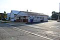
Looking east along Bluebush Road
|
|
| Motto(s):
"The Best Little Town in Michigan"
|
|

Location within Monroe County
|
|

Maybee, Michigan
Location in Michigan

Maybee, Michigan
Location in the United States
|
|
| Country | United States |
| State | Michigan |
| County | Monroe |
| Township | Exeter |
| Established | 1873 |
| Incorporated | 1899 |
| Government | |
| • Type | Village council |
| Area | |
| • Total | 1.01 sq mi (2.62 km2) |
| • Land | 1.00 sq mi (2.59 km2) |
| • Water | 0.01 sq mi (0.03 km2) |
| Elevation | 636 ft (194 m) |
| Population
(2010)
|
|
| • Total | 562 |
| • Estimate
(2019)
|
532 |
| • Density | 538.46/sq mi (207.94/km2) |
| Time zone | UTC-5 (Eastern (EST)) |
| • Summer (DST) | UTC-4 (EDT) |
| ZIP code(s) |
48159
48162 (Monroe) |
| Area code(s) | 734 |
| FIPS code | 26-52440 |
| GNIS feature ID | 631766 |
Maybee ( MAY-bee) is a village in Monroe County in the U.S. state of Michigan. The population was 562 at the 2010 census. The village is located within Exeter Township. Maybee was established in 1873 and incorporated as a village in 1899.
History
Maybee was named for Abram Maybee, who, along with Joseph Klotz, surveyed, platted, and sold the land that became the village between 1873 and 1875. The village was incorporated in 1899. Spurred on by the railroad, the village grew to include a grain elevator, grist mill, stone quarry, sand pit, hotel, three churches, two schools, and several small factories and stores. It is primarily an agricultural community. The grain elevator and quarry are still operating, along with several small businesses and restaurants.
Geography
According to the United States Census Bureau, the village has a total area of 1.01 square miles (2.62 km2), of which 1.00 square mile (2.59 km2) is land and 0.01 square miles (0.03 km2) is water.
Demographics
| Historical population | |||
|---|---|---|---|
| Census | Pop. | %± | |
| 1880 | 200 | — | |
| 1910 | 310 | — | |
| 1920 | 290 | −6.5% | |
| 1930 | 346 | 19.3% | |
| 1940 | 390 | 12.7% | |
| 1950 | 428 | 9.7% | |
| 1960 | 459 | 7.2% | |
| 1970 | 485 | 5.7% | |
| 1980 | 490 | 1.0% | |
| 1990 | 500 | 2.0% | |
| 2000 | 505 | 1.0% | |
| 2010 | 562 | 11.3% | |
| 2019 (est.) | 532 | −5.3% | |
| U.S. Decennial Census | |||
2010 census
As of the census of 2010, there were 562 people, 205 households, and 154 families living in the village. The population density was 562.0 inhabitants per square mile (217.0/km2). There were 223 housing units at an average density of 223.0 per square mile (86.1/km2). The racial makeup of the village was 96.6% White, 1.4% African American, 0.5% Native American, 0.4% Asian, 0.4% from other races, and 0.7% from two or more races. Hispanic or Latino of any race were 1.8% of the population.
There were 205 households, of which 42.0% had children under the age of 18 living with them, 59.0% were married couples living together, 13.2% had a female householder with no husband present, 2.9% had a male householder with no wife present, and 24.9% were non-families. 22.0% of all households were made up of individuals, and 5.3% had someone living alone who was 65 years of age or older. The average household size was 2.74 and the average family size was 3.23.
The median age in the village was 34.9 years. 31% of residents were under the age of 18; 5.3% were between the ages of 18 and 24; 26.9% were from 25 to 44; 30.9% were from 45 to 64; and 5.9% were 65 years of age or older. The gender makeup of the village was 49.8% male and 50.2% female.
Gallery
-
Monroe County Library Maybee Branch, Raisin St.
-
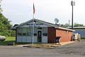
US Post Office, Mill St.
-
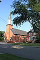
St. Joseph Catholic Church and parish office, Joseph St.


Education
There are no schools located within Maybee. Although the village is relatively small, it is served by two separate school districts. The majority of the village is served by Monroe Public Schools in the far northwest corner of the district's boundaries. A small portion of the village west of Baldwin Road is served by Dundee Community Schools at the easternmost point of the district's boundaries.
Images for kids
-
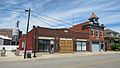
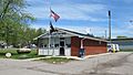
Current village hall -
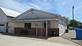
U.S. post office in Maybee -
Monroe County Library branch in Maybee -
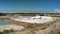
Stoneco Quarry
.jpg)
.jpg)


See also
 In Spanish: Maybee para niños
