
McCone County, Montana facts for kids
Quick facts for kids
McCone County
|
|
|---|---|
.jpg)
|
|

Location within the U.S. state of Montana
|
|
 Montana's location within the U.S. |
|
| Country | |
| State | |
| Founded | 1919 |
| Seat | Circle |
| Largest town | Circle |
| Area | |
| • Total | 2,683 sq mi (6,950 km2) |
| • Land | 2,643 sq mi (6,850 km2) |
| • Water | 40 sq mi (100 km2) 1.5% |
| Population
(2020)
|
|
| • Total | 1,729 |
| • Density | 0.64443/sq mi (0.24881/km2) |
| Time zone | UTC−7 (Mountain) |
| • Summer (DST) | UTC−6 (MDT) |
| Congressional district | At-large |
|
|
McCone County is a county located in the U.S. state of Montana. As of the 2020 census, the population was 1,729. Its county seat is Circle.
The county was created in 1919. It was named for State Senator George McCone, who had been one of the first county commissioners of Dawson County.
Contents
Geography
According to the U.S. Census Bureau, the county has a total area of 2,683 square miles (6,950 km2), of which 2,643 square miles (6,850 km2) is land and 40 square miles (100 km2) (1.5%) is water.
Major highways
 Montana Highway 13
 Montana Highway 24
 Montana Highway 200
Adjacent counties
- Valley County, Montana - north
- Roosevelt County, Montana - north
- Richland County, Montana - northeast
- Dawson County, Montana - east
- Prairie County, Montana - south
- Garfield County, Montana - west
National protected area
Demographics
| Historical population | |||
|---|---|---|---|
| Census | Pop. | %± | |
| 1920 | 4,747 | — | |
| 1930 | 4,790 | 0.9% | |
| 1940 | 3,744 | −21.8% | |
| 1950 | 3,258 | −13.0% | |
| 1960 | 3,321 | 1.9% | |
| 1970 | 2,875 | −13.4% | |
| 1980 | 2,702 | −6.0% | |
| 1990 | 2,276 | −15.8% | |
| 2000 | 1,977 | −13.1% | |
| 2010 | 1,734 | −12.3% | |
| 2020 | 1,729 | −0.3% | |
| U.S. Decennial Census 1790-1960 1900-1990 1990-2000 2010-2020 |
|||
2010 census
As of the 2010 census, there were 1,734 people, 774 households, and 514 families living in the county. The population density was 0.7 inhabitants per square mile (0.27/km2), the 10th lowest in the United States. There were 1,008 housing units at an average density of 0.4 per square mile (0.15/km2). The racial makeup of the county was 98.0% white, 0.4% American Indian, 0.1% black or African American, 0.1% Asian, 0.1% from other races, and 1.2% from two or more races. Those of Hispanic or Latino origin made up 0.7% of the population. In terms of ancestry, 44.5% were German, 23.1% were Norwegian, 12.7% were American, 12.0% were Irish, and 8.8% were English.
Of the 774 households, 23.4% had children under the age of 18 living with them, 61.0% were married couples living together, 3.2% had a female householder with no husband present, 33.6% were non-families, and 31.7% of all households were made up of individuals. The average household size was 2.22 and the average family size was 2.77. The median age was 48.9 years.
The median income for a household in the county was $48,167 and the median income for a family was $56,406. Males had a median income of $33,185 versus $26,454 for females. The per capita income for the county was $23,265. About 5.9% of families and 8.6% of the population were below the poverty line, including 10.3% of those under age 18 and 11.5% of those age 65 or over.
Communities
Town
- Circle (county seat)
Unincorporated communities
Images for kids
-
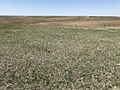
Typical McCone County landscape.
-
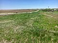
Looking south on MT 13 toward Vida.


See also
 In Spanish: Condado de McCone para niños
