McFarland, California facts for kids
Quick facts for kids
McFarland, California
|
|
|---|---|

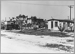
McFarland in 1940
|
|

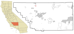
Location in Kern County and the state of California
|
|
| Country | |
| State | |
| County | Kern |
| Incorporated | July 18, 1957 |
| Area | |
| • Total | 2.67 sq mi (6.91 km2) |
| • Land | 2.67 sq mi (6.91 km2) |
| • Water | 0.00 sq mi (0.00 km2) 0% |
| Elevation | 354 ft (108 m) |
| Population
(2010)
|
|
| • Total | 12,707 |
| • Estimate
(2019)
|
15,506 |
| • Density | 5,811.84/sq mi (2,243.93/km2) |
| Time zone | UTC-8 (PST) |
| • Summer (DST) | UTC-7 (PDT) |
| ZIP code |
93250
|
| Area code(s) | 661 |
| FIPS code | 06-44826 |
| GNIS feature IDs | 1652750, 2411062 |
McFarland (formerly, Hunt and Lone Pine) is a city in the San Joaquin Valley, in Kern County, California, United States. McFarland is located 25 miles (40 km) north-northwest of Bakersfield and 6.5 miles (10 km) south of Delano, at an elevation of 354 feet (108 m). The population of McFarland was 12,707 at the 2010 census and an estimated 15,506 as of 2019.
Contents
History
The first post office opened in 1908. McFarland incorporated in 1957. The name honors J.B. McFarland, founder.
Demographics
| Historical population | |||
|---|---|---|---|
| Census | Pop. | %± | |
| 1960 | 3,686 | — | |
| 1970 | 4,177 | 13.3% | |
| 1980 | 5,151 | 23.3% | |
| 1990 | 7,005 | 36.0% | |
| 2000 | 9,618 | 37.3% | |
| 2010 | 12,707 | 32.1% | |
| 2019 (est.) | 15,506 | 22.0% | |
| U.S. Decennial Census | |||
2016
According to Data USA, the demographics of McFarland in 2016 were as follows:
- Population: 13,391 (up 2.79%)
- Median Age: 25.6 years
- Median Household Income: $33,687 (down 1.01%)
- Poverty Rate: 37.7%
- Employment Count: 4,298 (up 1.66%)
- Median Property Value: $136,700 (up 13.7%)
(all changes relative to 2015)
2010
At the 2010 census McFarland had a population of 12,707. The population density was 4,762.7 people per square mile (1,838.9/km2). The racial makeup of McFarland was 5,433 (42.8%) White, 236 (1.9%) African American, 171 (1.3%) Native American, 84 (0.7%) Asian, 6 (0.0%) Pacific Islander, 6,330 (49.8%) from other races, and 447 (3.5%) from two or more races. Hispanic or Latino of any race were 11,625 people (91.5%).
The census reported that 11,486 people (90.4% of the population) lived in households, 27 (0.2%) lived in non-institutionalized group quarters, and 1,194 (9.4%) were institutionalized.
There were 2,599 households, 1,818 (69.9%) had children under the age of 18 living in them, 1,663 (64.0%) were opposite-sex married couples living together, 456 (17.5%) had a female householder with no husband present, 246 (9.5%) had a male householder with no wife present. There were 189 (7.3%) unmarried opposite-sex partnerships, and 14 (0.5%) same-sex married couples or partnerships. 170 households (6.5%) were one person and 71 (2.7%) had someone living alone who was 65 or older. The average household size was 4.42. There were 2,365 families (91.0% of households); the average family size was 4.51.
The age distribution was 4,468 people (35.2%) under the age of 18, 1,700 people (13.4%) aged 18 to 24, 4,030 people (31.7%) aged 25 to 44, 1,925 people (15.1%) aged 45 to 64, and 584 people (4.6%) who were 65 or older. The median age was 25.7 years. For every 100 females, there were 128.3 males. For every 100 females age 18 and over, there were 142.4 males.
There were 2,683 housing units at an average density of 1,005.6 per square mile, of the occupied units 1,488 (57.3%) were owner-occupied and 1,111 (42.7%) were rented. The homeowner vacancy rate was 0.9%; the rental vacancy rate was 2.6%. 6,519 people (51.3% of the population) lived in owner-occupied housing units and 4,967 people (39.1%) lived in rental housing units.
2000
At the 2000 census there were 9,618 people in 1,990 households, including 1,789 families, in the city. The population density was 4,671.8 people per square mile (1,802.7/km2). There were 2,031 housing units at an average density of 986.5 per square mile (380.7/km2). The racial makeup of the city was 28.49% White, 3.19% Black or African American, 1.63% Native American, 0.69% Asian, 0.08% Pacific Islander, 61.23% from other races, and 4.69% from two or more races. 85.66% of the population were Hispanic or Latino of any race. Of the 1,990 households 61.7% had children under the age of 18 living with them, 64.4% were married couples living together, 17.3% had a female householder with no husband present, and 10.1% were non-families. 7.7% of households were one person and 4.7% were one person aged 65 or older. The average household size was 4.30 and the average family size was 4.45.
The age distribution was 35.1% under the age of 18, 14.1% from 18 to 24, 33.1% from 25 to 44, 12.8% from 45 to 64, and 4.8% 65 or older. The median age was 25 years. For every 100 females, there were 132.2 males. For every 100 females age 18 and over, there were 151.5 males.
The median income for a household in the city was $12,821, and the median family income was $14,190. Males had a median income of $19,881 versus $9,109 for females. The per capita income for the city was $9,524. About 34.1% of families and 35.2% of the population were below the poverty line, including 41.1% of those under age 18 and 12.1% of those age 65 or over.
Notable locations
- Fidel's hot rods
- Jackson Branch Kern County Library
- McFarland City Hall
- Peluqueria Charly "Charly The Barber"
- Maria's Pizza
- Palace Market
- Super King Burger
- McFarland Landfill Corporation
- Snowhite
- Tire Farm and Ranch
- Smoke Shop
- Poker's pizza
Local parks
- Arturo J. Munoz Park
- Ritchey Park
- Sherwood Park
- Browning Road Park
In popular culture
- McFarland was mentioned as the location of a cancer cluster in the MacGyver episode Bitter Harvest.
- The city is the titular location for the 2015 sports film, McFarland, USA.
See also
 In Spanish: McFarland (California) para niños


