
McLean County, Illinois facts for kids
Quick facts for kids
McLean County
|
|
|---|---|
.jpg)
|
|

Location within the U.S. state of Illinois
|
|
 Illinois's location within the U.S. |
|
| Country | |
| State | |
| Founded | December 25, 1830 |
| Named for | John McLean |
| Seat | Bloomington |
| Largest city | Bloomington |
| Area | |
| • Total | 1,186 sq mi (3,070 km2) |
| • Land | 1,183 sq mi (3,060 km2) |
| • Water | 2.9 sq mi (8 km2) 0.2% |
| Population
(2010)
|
|
| • Total | 169,572 |
| • Estimate
(2019)
|
171,517 |
| • Density | 142.98/sq mi (55.204/km2) |
| Time zone | UTC−6 (Central) |
| • Summer (DST) | UTC−5 (CDT) |
| Congressional districts | 13th, 18th |
McLean County is the largest county by land area in the U.S. state of Illinois. According to the 2010 census, it had a population of 169,572. Its county seat is Bloomington. McLean County is included in the Bloomington–Normal, IL Metropolitan Statistical Area.
Contents
Pronunciation
Locally, the second syllable of McLean is pronounced with a 'long a' (ā, IPA /ei/) sound (i.e. "muh-KLAIN") (as with native son McLean Stevenson), not with a 'long e' (ē, IPA /i/) sound ("muh-KLEEN").
History
McLean County was formed late in 1830 out of Tazewell County. It was named for John McLean, United States Senator for Illinois, who died in 1830.
-
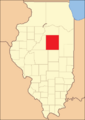
McLean County from the time of its creation to 1837
-
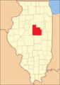
McLean County between 1837 and 1841
-
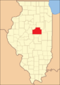
McLean County in 1841, reduced to its present borders


Geography
According to the U.S. Census Bureau, the county has a total area of 1,186 square miles (3,070 km2), of which 1,183 square miles (3,060 km2) is land and 2.9 square miles (7.5 km2) (0.2%) is water. It is the largest county in Illinois by land area and third-largest by total area. McLean County is actually larger than the land area of Rhode Island (1045 sq mi).
Climate and weather
| Weather chart for Bloomington, Illinois | |||||||||||||||||||||||||||||||||||||||||||||||
|---|---|---|---|---|---|---|---|---|---|---|---|---|---|---|---|---|---|---|---|---|---|---|---|---|---|---|---|---|---|---|---|---|---|---|---|---|---|---|---|---|---|---|---|---|---|---|---|
| J | F | M | A | M | J | J | A | S | O | N | D | ||||||||||||||||||||||||||||||||||||
|
1.7
31
14
|
1.7
37
18
|
2.9
48
29
|
3.8
61
40
|
4.5
73
51
|
3.9
83
61
|
4
86
65
|
3.8
84
63
|
3
77
54
|
2.7
65
42
|
3.1
49
31
|
2.4
36
20
|
||||||||||||||||||||||||||||||||||||
| temperatures in °F precipitation totals in inches source: The Weather Channel |
|||||||||||||||||||||||||||||||||||||||||||||||
|
Metric conversion
|
|||||||||||||||||||||||||||||||||||||||||||||||
In recent years, average temperatures in the county seat of Bloomington have ranged from a low of 14 °F (−10 °C) in January to a high of 86 °F (30 °C) in July, although a record low of −23 °F (−31 °C) was recorded in January 1985 and a record high of 103 °F (39 °C) was recorded in June 1988. Average monthly precipitation ranged from 1.71 inches (43 mm) in February to 4.52 inches (115 mm) in May.
Adjacent counties
- Woodford County - northwest
- Livingston County - northeast
- Ford County - east
- Champaign County - southeast
- Piatt County - south
- DeWitt County - south
- Logan County - southwest
- Tazewell County - west
Major highways
 Interstate 39
 Interstate 55
 Interstate 74
 U.S. Highway 24
 U.S. Highway 51
 U.S. Highway 66
 U.S. Highway 136
 U.S. Highway 150
 Illinois Route 9
 Illinois Route 54
 Illinois Route 122
 Illinois Route 165
 Illinois Route 251
Demographics
| Historical population | |||
|---|---|---|---|
| Census | Pop. | %± | |
| 1840 | 6,565 | — | |
| 1850 | 10,163 | 54.8% | |
| 1860 | 28,772 | 183.1% | |
| 1870 | 53,988 | 87.6% | |
| 1880 | 60,100 | 11.3% | |
| 1890 | 63,036 | 4.9% | |
| 1900 | 67,843 | 7.6% | |
| 1910 | 68,008 | 0.2% | |
| 1920 | 70,107 | 3.1% | |
| 1930 | 73,117 | 4.3% | |
| 1940 | 73,930 | 1.1% | |
| 1950 | 76,577 | 3.6% | |
| 1960 | 83,877 | 9.5% | |
| 1970 | 104,389 | 24.5% | |
| 1980 | 119,149 | 14.1% | |
| 1990 | 129,180 | 8.4% | |
| 2000 | 150,433 | 16.5% | |
| 2010 | 169,572 | 12.7% | |
| 2019 (est.) | 171,517 | 1.1% | |
| U.S. Decennial Census 1790-1960 1900-1990 1990-2000 2010-2019 |
|||
As of the 2010 United States Census, there were 169,572 people, 65,104 households, and 40,124 families residing in the county. The population density was 143.3 inhabitants per square mile (55.3/km2). There were 69,656 housing units at an average density of 58.9 per square mile (22.7/km2). The racial makeup of the county was 84.3% white, 7.3% black or African American, 4.3% Asian, 0.2% American Indian, 1.5% from other races, and 2.3% from two or more races. Those of Hispanic or Latino origin made up 4.4% of the population. In terms of ancestry, 31.2% were German, 15.4% were Irish, 11.4% were American, and 11.0% were English.
Of the 65,104 households, 31.4% had children under the age of 18 living with them, 48.5% were married couples living together, 9.6% had a female householder with no husband present, 38.4% were non-families, and 28.1% of all households were made up of individuals. The average household size was 2.44 and the average family size was 3.02. The median age was 32.1 years.
The median income for a household in the county was $57,642 and the median income for a family was $77,093. Males had a median income of $52,271 versus $39,685 for females. The per capita income for the county was $28,167. About 6.2% of families and 12.9% of the population were below the poverty line, including 11.4% of those under age 18 and 5.5% of those age 65 or over.
Communities
Cities
Town
Villages

Census-designated place
Other unincorporated communities
Townships
McLean County is divided into these townships:
- Allin
- Anchor
- Arrowsmith
- Bellflower
- Bloomington
- Blue Mound
- Cheney's Grove
- Chenoa
- Cropsey
- Dale
- Danvers
- Dawson
- Downs
- Dry Grove
- Empire
- Funk's Grove
- Gridley
- Hudson
- Lawndale
- Lexington
- Martin
- Money Creek
- Mount Hope
- Normal
- Old Town
- Randolph
- Towanda
- West
- White Oak
- Yates
Ghost towns
- Allin
- Benjaminville
- Kumler
Notable persons
- George J. Mecherle, founder of State Farm
- Adlai Stevenson II, Governor of Illinois (1949–53), two-time Democratic nominee for the U.S. presidency, and Ambassador to the United Nations (1961–65)
- Pokey LaFarge, musician and songwriter
- Bonnie Lou, recording artist and television celebrity
- William H. Rowe, farmer, businessman, and politician
See also
 In Spanish: Condado de McLean (Illinois) para niños
