
Melrose, Massachusetts facts for kids
Quick facts for kids
Melrose, Massachusetts
|
|||
|---|---|---|---|

Downtown Melrose.
|
|||
|
|||
| Motto(s):
One Community Open to All
|
|||

Location in Middlesex County in Massachusetts
|
|||

Melrose, Massachusetts
Location in the United States
|
|||
| Country | United States | ||
| State | Massachusetts | ||
| County | Middlesex | ||
| Settled | 1629 | ||
| Incorporated | 1850 | ||
| City | 1900 | ||
| Government | |||
| • Type | Mayor-council city | ||
| Area | |||
| • Total | 4.77 sq mi (12.35 km2) | ||
| • Land | 4.68 sq mi (12.13 km2) | ||
| • Water | 0.09 sq mi (0.22 km2) | ||
| Elevation | 133 ft (41 m) | ||
| Population
(2020)
|
|||
| • Total | 29,817 | ||
| • Density | 6,371.15/sq mi (2,458.12/km2) | ||
| Time zone | UTC−5 (Eastern) | ||
| • Summer (DST) | UTC−4 (Eastern) | ||
| ZIP Code |
02176
|
||
| Area code(s) | 339/781 | ||
| FIPS code | 25-40115 | ||
| GNIS feature ID | 0612780 | ||


Melrose is a city located in the Greater Boston metropolitan area in Middlesex County, Massachusetts, United States. Its population, per the 2020 United States Census, is 29,817. It is a suburb located approximately seven miles north of Boston. It is situated in the center of the triangle created by Interstates 93, 95 and U.S. Route 1.
The land that comprises Melrose was first settled in 1628 and was once part of Charlestown and then Malden. It became the Town of Melrose in 1850 and then the City of Melrose in 1900.
Contents
History
Melrose was originally called "Ponde Fielde" for its abundance of ponds and streams or "Mystic Side" because of its location in a valley north of the Mystic River. The area was first explored by Richard and Ralph Sprague in 1628, and became part of Charlestown in 1633 along with a large area of land encompassing most of the surrounding communities. In 1649, the neighborhood of Charlestown known as Malden was incorporated as a separate town; the new town of Malden included most of present-day Melrose (then called North Malden) within its borders. North Malden largely remained a lightly populated farming community.
In 1845, the Boston and Maine Railroad built three stops (now the commuter rail stations of Wyoming Hill, Melrose/Cedar Park, and Melrose Highlands). Boston workers in search of a country atmosphere moved to the area and began commuting to work. The population of North Malden began growing, and in 1850 North Malden split from Malden proper and was incorporated as the town of Melrose. Melrose annexed the highlands from neighboring Stoneham in 1853, creating the city's current borders.
The population of Melrose continued to grow throughout the second half of the nineteenth century. Farmland was increasingly partitioned into smaller parcels for residences and businesses. The fire department and the town's school district were founded and town hall was built in 1873. In 1899, the City of Melrose became the 33rd incorporated city in Massachusetts. Levi S. Gould became the city’s first mayor on January 1, 1900.
The population of Melrose peaked at 33,180 in 1970 before beginning a slow decline continuing through 2010. On April 1, 1982, downtown Melrose was added to the National Register of Historic Places; the public library was similarly added to the register in 1988.
Name
The name "Melrose" comes from the burgh of Melrose, Scotland. It was a reference to the hills of Melrose, Scotland which the new town resembled. The name was suggested and advocated for by William Bogle, a Scotland native and longtime resident of North Malden.
Geography
Melrose is located at 42°27′33″N 71°3′44″W / 42.45917°N 71.06222°W (42.459045, −71.062339).
According to the United States Census Bureau, the city has a total area of 4.8 square miles (12 km2), of which 4.7 square miles (12 km2) is land and 0.1 square miles (0.26 km2), or 1.26%, is water. The city's largest body of water is Ell Pond, situated near the center of the city, while other major bodies are Swains Pond and Towners Pond, located on the east side near Mount Hood Golf Club.
Melrose is approximately 7 miles (11 km) north of Boston, Massachusetts. It borders four cities and towns: Malden, Saugus, Stoneham, and Wakefield. Major geographic features include Ell Pond, Swains Pond, Sewall Woods, Mount Hood, Boston Rock, Pine Banks Park, and the eastern reaches of the Middlesex Fells Reservation.
The writer Elizabeth George Speare, who was born in Melrose, wrote of her hometown: "Melrose was an ideal place in which to have grown up, close to fields and woods where we hiked and picnicked, and near to Boston where we frequently had family treats of theaters and concerts."
Demographics
| Historical population | ||
|---|---|---|
| Year | Pop. | ±% |
| 1850 | 1,260 | — |
| 1860 | 2,532 | +101.0% |
| 1870 | 3,414 | +34.8% |
| 1880 | 4,560 | +33.6% |
| 1890 | 8,519 | +86.8% |
| 1900 | 12,962 | +52.2% |
| 1910 | 15,715 | +21.2% |
| 1920 | 18,204 | +15.8% |
| 1930 | 23,170 | +27.3% |
| 1940 | 25,333 | +9.3% |
| 1950 | 26,988 | +6.5% |
| 1960 | 29,619 | +9.7% |
| 1970 | 33,180 | +12.0% |
| 1980 | 30,055 | −9.4% |
| 1990 | 28,150 | −6.3% |
| 2000 | 27,134 | −3.6% |
| 2010 | 26,983 | −0.6% |
| 2020 | 29,817 | +10.5% |
| * = population estimate. Source: United States Census records and Population Estimates Program data. Source: |
||
As of the census of 2010, there were 26,983 people, 11,213 households, and 7,076 families residing in the city. The racial makeup of the city was 91.1% White, 2.4% African American, 0.1% Native American, 3.8% Asian, 0.9% from other races, and 1.7% from two or more races. Hispanic or Latino of any race were 2.5% of the population.
There were 11,213 households, out of which 28.4% had children under the age of 18 living with them, 51.4% were married couples living together, 9.1% had a female householder with no husband present, and 36.9% were non-families. Of all households, 31.3% were individuals living alone, and 13.5% were composed of an individual 65 years or older living alone. The average household size was 2.38, and the average family size was 3.05.
In the city, the population was spread out, with 23.5% under the age of 20, 4.0% from 20 to 24, 27.4% from 25 to 44, 29.2% from 45 to 64, and 15.9% who were 65 years of age or older. The median age was 41.9 years. For every 100 females, there were 88.8 males. For every 100 females age 18 and over, there were 85.4 males.
Transportation
Although the only highway in Melrose is a short section of Route 99, the city has access to many nearby highways including Route 1 in Saugus, Interstate 93 in Stoneham, Massachusetts Route 16 in Everett, and Route 128/Interstate 95 in Wakefield. The city is also served by the MBTA. Service includes four bus routes: 131, 132, 136 and 137. There are three commuter rail stations: Wyoming Hill, Melrose/Cedar Park, and Melrose Highlands. Oak Grove, the northern terminus of the MBTA's Orange Line subway system, is located in Malden on the Melrose city line. Oak Grove is primarily a park-and-ride station.
Neighborhoods

- Cedar Park
- Downtown Melrose
- East Side
- Franklin Square
- Horace Mann
- Melrose Highlands
- Mount Hood
- Oak Grove/Pine Banks
- Wyoming
- Bellevue
- Fells
Education
.jpg)
The Melrose School district runs several schools including The Franklin Early Childhood Center, five elementary schools (Roosevelt, Lincoln, Winthrop, Hoover, and Horace Mann), Melrose Veterans Memorial Middle School (MVMMS), and Melrose High School. The city also has a private elementary school, St. Mary of the Annunciation, run by one of the city's Catholic churches of the same name. The Franklin Early Childhood Center houses preschool, Pre-K, and multiage programs. MVMMS is a school to about one thousand eleven- through fourteen-year-olds and was the winner of the 2002 Massachusetts Department of Education's Compass School Award, the 2007 Massachusetts Technology Collaborative's Green School Award (for its use of solar energy), and the 2008 New England League of Middle Schools' Spotlight School Award.
Images for kids
-
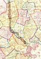
1852 map of Boston area showing Melrose and rail lines
-
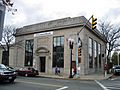
Former MassBank building downtown which was used for a bank scene in the movie The Town (2010)
-
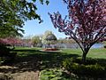
The Gazebo at Ell Pond Park
_map.jpg)


See also
 In Spanish: Melrose (Massachusetts) para niños
