Mercer County, West Virginia facts for kids
Quick facts for kids
Mercer County
|
|
|---|---|

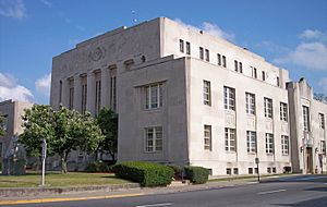
The Mercer County Courthouse in Princeton in 2007
|
|

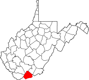
Location within the U.S. state of West Virginia
|
|
 West Virginia's location within the U.S. |
|
| Country | |
| State | |
| Founded | March 17, 1837 |
| Seat | Princeton |
| Largest city | Bluefield |
| Area | |
| • Total | 421 sq mi (1,090 km2) |
| • Land | 419 sq mi (1,090 km2) |
| • Water | 1.7 sq mi (4 km2) 0.4%% |
| Population
(2010)
|
|
| • Total | 62,264 |
| • Estimate
(2019)
|
58,758 |
| • Density | 147.90/sq mi (57.10/km2) |
| Time zone | UTC−5 (Eastern) |
| • Summer (DST) | UTC−4 (EDT) |
| Congressional district | 3rd |
Mercer County is a county on the southeastern border of the U.S. state of West Virginia. At the 2010 census, the population was 62,264. Its county seat is Princeton. The county was originally established in the State of Virginia by act of its General Assembly on March 17, 1837, using lands taken from Giles and Tazewell counties.
Mercer County is part of the Bluefield, WV-VA Micropolitan Statistical Area.
Contents
Geography
According to the U.S. Census Bureau, the county has a total area of 421 square miles (1,090 km2), of which 419 square miles (1,090 km2) is land and 1.7 square miles (4.4 km2) (0.4%) is water.
Major highways
The West Virginia Turnpike, now part of Interstate 77, begins in Princeton.
Adjacent counties
- Raleigh County (north)
- Summers County (northeast)
- Giles County, Virginia (east)
- Bland County, Virginia (south)
- Tazewell County, Virginia (southwest)
- McDowell County (west)
- Wyoming County (northwest)
National protected area
Demographics
| Historical population | |||
|---|---|---|---|
| Census | Pop. | %± | |
| 1840 | 2,233 | — | |
| 1850 | 4,222 | 89.1% | |
| 1860 | 6,819 | 61.5% | |
| 1870 | 7,064 | 3.6% | |
| 1880 | 7,467 | 5.7% | |
| 1890 | 16,002 | 114.3% | |
| 1900 | 23,023 | 43.9% | |
| 1910 | 38,371 | 66.7% | |
| 1920 | 49,558 | 29.2% | |
| 1930 | 61,323 | 23.7% | |
| 1940 | 68,289 | 11.4% | |
| 1950 | 75,013 | 9.8% | |
| 1960 | 68,206 | −9.1% | |
| 1970 | 63,206 | −7.3% | |
| 1980 | 73,942 | 17.0% | |
| 1990 | 64,980 | −12.1% | |
| 2000 | 62,980 | −3.1% | |
| 2010 | 62,264 | −1.1% | |
| 2019 (est.) | 58,758 | −5.6% | |
| U.S. Decennial Census 1790–1960 1900–1990 1990–2000 2010–2019 |
|||
2010 census
As of the 2010 United States Census, there were 62,264 people, 26,603 households, and 17,313 families living in the county. The population density was 148.6 inhabitants per square mile (57.4/km2). There were 30,115 housing units at an average density of 71.9 per square mile (27.8/km2). The racial makeup of the county was 91.6% white, 6.1% black or African American, 0.5% Asian, 0.2% American Indian, 0.2% from other races, and 1.4% from two or more races. Those of Hispanic or Latino origin made up 0.8% of the population. In terms of ancestry, 16.4% were Irish, 14.2% were German, 12.0% were English, and 11.2% were American.
Of the 26,603 households, 27.8% had children under the age of 18 living with them, 47.6% were married couples living together, 12.9% had a female householder with no husband present, 34.9% were non-families, and 30.1% of all households were made up of individuals. The average household size was 2.30 and the average family size was 2.83. The median age was 42.5 years.
The median income for a household in the county was $32,131 and the median income for a family was $42,517. Males had a median income of $37,423 versus $25,778 for females. The per capita income for the county was $18,431. About 16.0% of families and 22.8% of the population were below the poverty line, including 32.5% of those under age 18 and 11.4% of those age 65 or over.
Communities
Cities
Towns
Census-designated places
Education
The Mercer County Public School System has nineteen elementary schools, including Athens, Bluefield Intermediate, Bluewell, Brushfork, Ceres, Glenwood Elementary, Lashmeet-Matoaka, Melrose, Memorial, Mercer County Early Learning - Bluefield and Princeton sites, Mercer, Montcalm, Oakvale (funding for constructing a new Oakvale school has been approved), Princeton Primary, Spanishburg, Straley, Sun Valley and Whitethorn. There are six middle school facilities including Princeton Middle, Bluefield Middle, Montcalm Middle, PikeView Middle, and Glenwood Middle. There are also four high school facilities, including Princeton Senior (AAA), Bluefield High (AA), Montcalm High (A) and PikeView High (AA). The Mercer County Technical Education Center, which is being transitioned into a comprehensive technical high school. Mercer County Schools educates approximately 9200 students. The professional and service staff number about 1200.
Higher educational institutions include Bluefield State College, located in Bluefield; Concord University, located in Athens; and New River Community and Technical College, located in Princeton, West Virginia.
See also
 In Spanish: Condado de Mercer (Virginia Occidental) para niños

