
Merewether, New South Wales facts for kids
Quick facts for kids MerewetherNewcastle, New South Wales |
|||||||||||||||
|---|---|---|---|---|---|---|---|---|---|---|---|---|---|---|---|

Merewether Beach
|
|||||||||||||||

Merewether
Location in New South Wales
|
|||||||||||||||
| Population | 10,964 (2016 census) | ||||||||||||||
| • Density | 3,049.4/km2 (7,898/sq mi) | ||||||||||||||
| Established | 1890 | ||||||||||||||
| Postcode(s) | 2291 | ||||||||||||||
| Area | 6.1 km2 (2.4 sq mi) | ||||||||||||||
| Location |
|
||||||||||||||
| LGA(s) | City of Newcastle | ||||||||||||||
| Region | Hunter | ||||||||||||||
| County | Northumberland | ||||||||||||||
| Parish | Newcastle | ||||||||||||||
| State electorate(s) | Newcastle | ||||||||||||||
| Federal Division(s) | Newcastle | ||||||||||||||
|
|||||||||||||||
Merewether is a suburb of Newcastle, New South Wales, Australia, located 3 km (2 mi) from Newcastle's central business district with a population of around 11,000. The suburb stretches 3 km (2 mi) from Merewether Beach in the east to Adamstown in the west.
Contents
Establishment
Merewether was originally part of the Burwood Estate, and takes its name from the owner, Edward Christopher Merewether. The Church of England parish church is St.Augustine, in Llewellyn Street, the land and cost of erection met by Mr. Edward Merewether. It became the centre of a new Provisional District in the Diocese of Newcastle in 1890. In 1891 the Census gave the population as 4,700. Merewether was incorporated as a Municipality in 1885, covering 1,110 acres (4.5 km2) and 31 km (19 mi) of streets. The Mayor in 1901 was David Lloyd, a funeral director who resided in Railway Street. The former Council Chambers, opposite the Post Office, are today the clubhouse of the Australian Returned Services League. In 1938 an Act of the New South Wales Parliament created a "City of Greater Newcastle", incorporating 11 municipalities into one local government area, including Merewether.
Beaches

The suburb of Merewether includes some of Newcastle's most famous beaches. Dixon Park Beach leads south onto Merewether Beach and a little further to the more isolated Burwood Beach which leads to Glenrock Lagoon. At the southern end of Merewether Beach are the Merewether Ocean Baths, the largest ocean baths in the Southern Hemisphere. Merewether Beach is home to Merewether SLSC the oldest lifesaving club in the Hunter Region and the Merewether Surfboard Club the most successful boardriders club in Australia
In 2006, organisers of Newcastle Surfest announced that the competition would be moving from Newcastle Beach to Merewether Beach, in order to capitalise on the beaches superior surfing conditions, caused by the rock bottom of the beach, compared to the mud bottom of Newcastle Beach.
Professional Surfer Mark Richards is a resident of Merewether.
General

Merewether, once served by electric tramways to the city, and today by buses, has excellent road connections to all sections of Newcastle and the major highways which serve it. Merewether's oldest mansion is Hillcrest, originally the residence of the Merewether family. Above it is the Scenic Drive with many expensive 'modern' homes, which date from the late 1950s upwards, with spectacular views.

Following 18 months construction, Merewether Bowling Club, with one green, was opened on 6 February 1954 upon a long-closed old colliery west of the railway line, in Caldwell Street. Following the closure of the railway in 1960 the land it occupied next to the club was purchased and another green established, and on Sunday 12 February 1967, Club President Wallace Frost opened the "magnificent" and extensive new Club House which had cost $100,000 dollars.
At Merewether is the Lingard Private Hospital, in the lower part of Merewether Street.
- Approximately 44% of Merewether is uninhabited bushland that forms part of the Glenrock State Conservation Area. The density figure represents the average population density in the populated area of the suburb.
- Newcastle - 150 Years, edited by Eric Lingard, Newcastle, 1947.
- The Diocese of Newcastle, by A.P.Elkin, Sydney, 1955.
Education


There are three primary schools in the suburb - Merewether Public [State] School in Henry Street at the Glebe, the Catholic Holy Family Primary School in Janet Street, and Hamilton South Public School which is actually located within the Merewether postcode area on Kenrick Street. Two more, Merewether Heights Public School on Scenic Drive and The Junction Public School (founded in 1860) are located in Merewether Heights and The Junction respectively, on the borders that those suburbs share with Merewether. (The Junction only became a gazetted separate suburb in 1991). Pupils from the schools feed into the secondary schools of Newcastle High School, Kotara High School, the Catholic St Pius X college at Adamstown or the Anglican-affiliated Newcastle Grammar School. Merewether High School, an academic selective public school, is actually located 600 m (1,969 ft) from Merewether in the suburb of Broadmeadow.
Images for kids
-
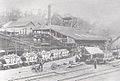
Newcastle Coal Company's Colliery at the Glebe, c1900.
-
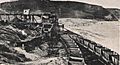
Coal-loader for Glenrock Colliery, Murdering Gully, Merewether, closed March 1944.
-
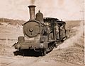
The last loaded coal train leaves the Glebe and is about to cross Yule Road, 24 Aug 1954.
-
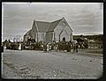
Funeral of Glebe Pit men, St Augustine's Church, Merewether, 3 July 1889


