
Mesoamerica facts for kids

Mesoamerica (literally, "central America") is a geographical region. It begins from around the Tropic of Cancer in central Mexico and ends near Costa Rica. The term is especially used to mean the native peoples and cultures that were there before the Spanish took over that region.
Geography
_-_Guatemala_1828_-_La_Danta_at_the_Mayan_site_of_El_Mirador.jpg)

Located on the Middle American isthmus joining North and South America between ca. 10° and 22° northern latitude, Mesoamerica possesses a complex combination of ecological systems, topographic zones, and environmental contexts. A main distinction groups these different niches into two broad categories: the lowlands (those areas between sea level and 1000 meters) and the altiplanos, or highlands (situated between 1,000 and 2,000 meters above sea level). In the low-lying regions, sub-tropical and tropical climates are most common, as is true for most of the coastline along the Pacific and Gulf of Mexico and the Caribbean Sea. The highlands show much more climatic diversity, ranging from dry tropical to cold mountainous climates; the dominant climate is temperate with warm temperatures and moderate rainfall. The rainfall varies from the dry Oaxaca and north Yucatán to the humid southern Pacific and Caribbean lowlands.
Cultural sub-areas
Several distinct sub-regions within Mesoamerica are defined by a convergence of geographic and cultural attributes. These sub-regions are more conceptual than culturally meaningful, and the demarcation of their limits is not rigid. The Maya area, for example, can be divided into two general groups: the lowlands and highlands. The lowlands are further divided into the southern and northern Maya lowlands. The southern Maya lowlands are generally regarded as encompassing northern Guatemala, southern Campeche and Quintana Roo in Mexico, and Belize. The northern lowlands cover the remainder of the northern portion of the Yucatán Peninsula. Other areas include Central Mexico, West Mexico, the Gulf Coast Lowlands, Oaxaca, the Southern Pacific Lowlands, and Southeast Mesoamerica (including northern Honduras).
Topography
There is extensive topographic variation in Mesoamerica, ranging from the high peaks circumscribing the Valley of Mexico and within the central Sierra Madre mountains to the low flatlands of the northern Yucatán Peninsula. The tallest mountain in Mesoamerica is Pico de Orizaba, a dormant volcano located on the border of Puebla and Veracruz. Its peak elevation is 5,636 m (18,490 ft).
The Sierra Madre mountains, which consist of several smaller ranges, run from northern Mesoamerica south through Costa Rica. The chain is historically volcanic. In central and southern Mexico, a portion of the Sierra Madre chain is known as the Eje Volcánico Transversal, or the Trans-Mexican volcanic belt. There are 83 inactive and active volcanoes within the Sierra Madre range, including 11 in Mexico, 37 in Guatemala, 23 in El Salvador, 25 in Nicaragua, and 3 in northwestern Costa Rica. According to the Michigan Technological University, 16 of these are still active. The tallest active volcano is Popocatépetl at 5,452 m (17,887 ft). This volcano, which retains its Nahuatl name, is located 70 km (43 mi) southeast of Mexico City. Other volcanoes of note include Tacana on the Mexico–Guatemala border, Tajumulco and Santamaría in Guatemala, Izalco in El Salvador, Momotombo in Nicaragua, and Arenal in Costa Rica.
One important topographic feature is the Isthmus of Tehuantepec, a low plateau that breaks up the Sierra Madre chain between the Sierra Madre del Sur to the north and the Sierra Madre de Chiapas to the south. At its highest point, the Isthmus is 224 m (735 ft) above mean sea level. This area also represents the shortest distance between the Gulf of Mexico and the Pacific Ocean in Mexico. The distance between the two coasts is roughly 200 km (120 mi). The northern side of the Isthmus is swampy and covered in dense jungle—but the Isthmus of Tehuantepec, as the lowest and most level point within the Sierra Madre mountain chain, was nonetheless a main transportation, communication, and economic route within Mesoamerica.
Bodies of water
Outside of the northern Maya lowlands, rivers are common throughout Mesoamerica. Some of the more important ones served as loci of human occupation in the area. The longest river in Mesoamerica is the Usumacinta, which forms in Guatemala at the convergence of the Salinas or Chixoy and La Pasion River and runs north for 970 km (600 mi) – 480 km (300 mi) of which are navigable – eventually draining into the Gulf of Mexico. Other rivers of note include the Rio Grande de Santiago, the Grijalva River, the Motagua River, the Ulúa River, and the Hondo River. The northern Maya lowlands, especially the northern portion of the Yucatán peninsula, are notable for their nearly complete lack of rivers (largely due to the absolute lack of topographic variation). Additionally, no lakes exist in the northern peninsula. The main source of water in this area is aquifers that are accessed through natural surface openings called cenotes.
With an area of 8,264 km2 (3,191 sq mi), Lake Nicaragua is the largest lake in Mesoamerica. Lake Chapala is Mexico’s largest freshwater lake, but Lake Texcoco is perhaps most well known as the location upon which Tenochtitlan, capital of the Aztec Empire, was founded. Lake Petén Itzá, in northern Guatemala, is notable as where the last independent Maya city, Tayasal (or Noh Petén), held out against the Spanish until 1697. Other large lakes include Lake Atitlán, Lake Izabal, Lake Güija, Lemoa, and Lake Managua.
Biodiversity
Almost all ecosystems are present in Mesoamerica; the more well known are the Mesoamerican Barrier Reef System, the second largest in the world, and La Mosquitia (consisting of the Rio Platano Biosphere Reserve, Tawahka Asangni, Patuca National Park, and Bosawas Biosphere Reserve) a rainforest second in size in the Americas only to the Amazonas. The highlands present mixed and coniferous forest. The biodiversity is among the richest in the world, though the number of species in the red list of the IUCN grows every year.
Chronology and culture

The history of human occupation in Mesoamerica is divided into stages or periods. These are known, with slight variation depending on region, as the Paleo-Indian, the Archaic, the Preclassic (or Formative), the Classic, and the Postclassic. The last three periods, representing the core of Mesoamerican cultural fluorescence, are further divided into two or three sub-phases. Most of the time following the arrival of the Spanish in the 16th century is classified as the Colonial period.
The differentiation of early periods (i.e., up through the end of the Late Preclassic) generally reflects different configurations of socio-cultural organization that are characterized by increasing socio-political complexity, the adoption of new and different subsistence strategies, and changes in economic organization (including increased interregional interaction). The Classic period through the Postclassic are differentiated by the cyclical crystallization and fragmentation of the various political entities throughout Mesoamerica.
Paleo-Indian
The Mesoamerican Paleo-Indian period precedes the advent of agriculture and is characterized by a nomadic hunting and gathering subsistence strategy. Big-game hunting, similar to that seen in contemporaneous North America, was a large component of the subsistence strategy of the Mesoamerican Paleo-Indian. These sites had obsidian blades and Clovis-style fluted projectile points.
Archaic
The Archaic period (8000–2000 BC) is characterized by the rise of incipient agriculture in Mesoamerica. The initial phases of the Archaic involved the cultivation of wild plants, transitioning into informal domestication and culminating with sedentism and agricultural production by the close of the period. Transformations of natural environments have been a common feature at least since the mid Holocene . Archaic sites include Sipacate in Escuintla, Guatemala, where maize pollen samples date to c. 3500 BC.
Preclassic / Formative

The first complex civilization to develop in Mesoamerica was that of the Olmec, who inhabited the gulf coast region of Veracruz throughout the Preclassic period. The main sites of the Olmec include San Lorenzo Tenochtitlán, La Venta, and Tres Zapotes. Specific dates vary, but these sites were occupied from roughly 1200 to 400 BC. Remains of other early cultures interacting with the Olmec have been found at Takalik Abaj, Izapa, and Teopantecuanitlan, and as far south as in Honduras. Research in the Pacific Lowlands of Chiapas and Guatemala suggest that Izapa and the Monte Alto Culture may have preceded the Olmec. Radiocarbon samples associated with various sculptures found at the Late Preclassic site of Izapa suggest a date of between 1800 and 1500 BC.
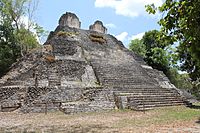
During the Middle and Late Preclassic period, the Maya civilization developed in the southern Maya highlands and lowlands, and at a few sites in the northern Maya lowlands. The earliest Maya sites coalesced after 1000 BC, and include Nakbe, El Mirador, and Cerros. Middle to Late Preclassic Maya sites include Kaminaljuyú, Cival, Edzná, Lamanai, Komchen, Dzibilchaltun, and San Bartolo, among others.
The Preclassic in the central Mexican highlands is represented by such sites as Tlapacoya, Tlatilco, and Cuicuilco. These sites were eventually superseded by Teotihuacán, an important Classic-era site that eventually dominated economic and interaction spheres throughout Mesoamerica. The settlement of Teotihuacan is dated to the later portion of the Late Preclassic, or roughly AD 50.
In the Valley of Oaxaca, San José Mogote represents one of the oldest permanent agricultural villages in the area, and one of the first to use pottery. During the Early and Middle Preclassic, the site developed some of the earliest examples of defensive palisades, ceremonial structures, the use of adobe, and hieroglyphic writing. Also of importance, the site was one of the first to demonstrate inherited status, signifying a radical shift in socio-cultural and political structure. San José Mogote was eventual overtaken by Monte Albán, the subsequent capital of the Zapotec empire, during the Late Preclassic.
The Preclassic in western Mexico, in the states of Nayarit, Jalisco, Colima, and Michoacán also known as the Occidente, is poorly understood. This period is best represented by the thousands of figurines recovered by looters and ascribed to the "shaft tomb tradition".
Preclassic gallery
-
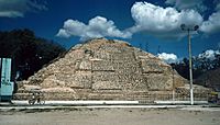
Cuicuilco 800–600 BC
-
Nakbé, Mid Preclassic (600 BC) Palace remains, The Mirador Basin
-
The partly excavated main structure of San Jose Mogote 1500–500 BC
-
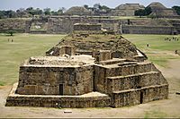
Monte Alban, Building J in the foreground. 200 BC – AD 200


Classic
Early Classic

The Classic period is marked by the rise and dominance of several polities. The traditional distinction between the Early and Late Classic are marked by their changing fortune and their ability to maintain regional primacy. Of paramount importance are Teotihuacán in central Mexico and Tikal in Guatemala; the Early Classic’s temporal limits generally correlate to the main periods of these sites. Monte Alban in Oaxaca is another Classic-period polity that expanded and flourished during this period, but the Zapotec capital exerted less interregional influence than the other two sites.
During the Early Classic, Teotihuacan participated in and perhaps dominated a far-reaching macro-regional interaction network. Architectural and artifact styles (talud-tablero, tripod slab-footed ceramic vessels) epitomized at Teotihuacan were mimicked and adopted at many distant settlements. Pachuca obsidian, whose trade and distribution is argued to have been economically controlled by Teotihuacan, is found throughout Mesoamerica.
Tikal came to dominate much of the southern Maya lowlands politically, economically, and militarily during the Early Classic. An exchange network centered at Tikal distributed a variety of goods and commodities throughout southeast Mesoamerica, such as obsidian imported from central Mexico (e.g., Pachuca) and highland Guatemala (e.g., El Chayal, which was predominantly used by the Maya during the Early Classic), and jade from the Motagua valley in Guatemala. Tikal was often in conflict with other polities in the Petén Basin, as well as with others outside of it, including Uaxactun, Caracol, Dos Pilas, Naranjo, and Calakmul. Towards the end of the Early Classic, this conflict lead to Tikal’s military defeat at the hands of Caracol in 562, and a period commonly known as the Tikal Hiatus.
Early Classic gallery
-
Great Goddess of Teotihuacan AD 200–500
-
A reconstruction of Guachimontones, flourished from AD 200–400
-
Temple of the Owl, Dzibanche AD 200–600
-
Acanceh, AD 200–300
-
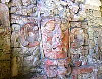
Mask located on the "Temple of the Masks" Kohunlich c. AD 500


.jpg)


Late Classic

The Late Classic period (beginning ca. AD 600 until AD 909 [varies]) is characterized as a period of interregional competition and factionalization among the numerous regional polities in the Maya area. This largely resulted from the decrease in Tikal’s socio-political and economic power at the beginning of the period. It was therefore during this time that other sites rose to regional prominence and were able to exert greater interregional influence, including Caracol, Copán, Palenque, and Calakmul (which was allied with Caracol and may have assisted in the defeat of Tikal), and Dos Pilas Aguateca and Cancuén in the Petexbatún region of Guatemala. Around 710, Tikal arose again and started to build strong alliances and defeat its worst enemies. In the Maya area, the Late Classic ended with the so-called "Maya collapse", a transitional period coupling the general depopulation of the southern lowlands and development and florescence of centers in the northern lowlands.
Late Classic gallery
-
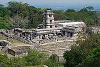
Main palace of Palenque, AD 7th century
-
K'inich Janaab Pakal I of Palenque AD 603–683
-
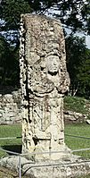
Copan Stela H commissioned by Uaxaclajuun Ub'aah K'awiil AD 695–738
-
Jaina Island type figure (Maya) AD 650–800
-
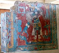
Cacaxtla, Mural depicting the Bird Man AD 650–900


.jpg)
.jpg)
Terminal Classic

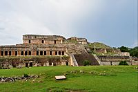
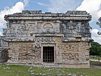
Generally applied to the Maya area, the Terminal Classic roughly spans the time between AD 800/850 and ca. AD 1000. Overall, it generally correlates with the rise to prominence of Puuc settlements in the northern Maya lowlands, so named after the hills where they are mainly found. Puuc settlements are specifically associated with a unique architectural style (the "Puuc architectural style") that represents a technological departure from previous construction techniques. Major Puuc sites include Uxmal, Sayil, Labna, Kabah, and Oxkintok. While generally concentrated within the area in and around the Puuc hills, the style has been documented as far away as at Chichen Itza to the east and Edzna to the south.
Chichén Itzá was originally thought to have been a Postclassic site in the northern Maya lowlands. Research over the past few decades has established that it was first settled during the Early/Late Classic transition but rose to prominence during the Terminal Classic and Early Postclassic. During its apogee, this widely known site economically and politically dominated the northern lowlands. Its participation in the circum-peninsular exchange route, possible through its port site of Isla Cerritos, allowed Chichén Itzá to remain highly connected to areas such as central Mexico and Central America. The apparent "Mexicanization" of architecture at Chichén Itzá led past researchers to believe that Chichén Itzá existed under the control of a Toltec empire. Chronological data refutes this early interpretation, and it is now known that Chichén Itzá predated the Toltec; Mexican architectural styles are now used as an indicator of strong economic and ideological ties between the two regions.
Terminal Classic gallery
-
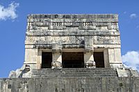
Chichen Itza, Temple of the Jaguars AD 900–1000
-
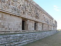
Governor's Palace rear view and details, AD 10th century, Uxmal
-
Temple of the Masks, Kabah
-
Sayil, three-story palace, AD 600–900
-
Chichen Itza, "Temple of Three Dintels" AD 600–1000


.jpg)


Postclassic
The Postclassic (beginning AD 900–1000, depending on area) is, like the Late Classic, characterized by the cyclical crystallization and fragmentation of various polities. The main Maya centers were located in the northern lowlands. Following Chichén Itzá, whose political structure collapsed during the Early Postclassic, Mayapán rose to prominence during the Middle Postclassic and dominated the north for c. 200 years. After Mayapán’s fragmentation, political structure in the northern lowlands revolved around large towns or city-states, such as Oxkutzcab and Ti’ho (Mérida, Yucatán), that competed with one another.

Toniná, in the Chiapas highlands, and Kaminaljuyú in the central Guatemala highlands, were important southern highland Maya centers. The latter site, Kaminaljuyú, is one of the longest occupied sites in Mesoamerica and was continuously inhabited from c. 800 BC to around AD 1200. Other important highland Maya groups include the K'iche' of Utatlán, the Mam in Zaculeu, the Poqomam in Mixco Viejo, and the Kaqchikel at Iximche in the Guatemalan highlands. The Pipil resided in El Salvador, while the Ch'orti' were in eastern Guatemala and northwestern Honduras.
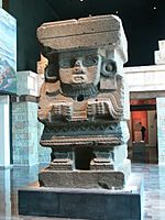
In central Mexico, the early portion of the Postclassic correlates with the rise of the Toltec and an empire based at their capital, Tula (also known as Tollan). Cholula, initially an important Early Classic center contemporaneous with Teotihuacan, maintained its political structure (it did not collapse) and continued to function as a regionally important center during the Postclassic. The latter portion of the Postclassic is generally associated with the rise of the Mexica and the Aztec Empire. One of the more commonly known cultural groups in Mesoamerica, the Aztec politically dominated nearly all of central Mexico, the Gulf Coast, Mexico’s southern Pacific Coast (Chiapas and into Guatemala), Oaxaca, and Guerrero.
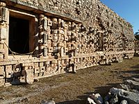
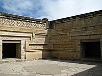
The Tarascans (also known as the P'urhépecha) were located in Michoacán and Guerrero. With their capital at Tzintzuntzan, the Tarascan state was one of the few to actively and continuously resist Aztec domination during the Late Postclassic. Other important Postclassic cultures in Mesoamerica include the Totonac along the eastern coast (in the modern-day states of Veracruz, Puebla, and Hidalgo). The Huastec resided north of the Totonac, mainly in the modern-day states of Tamaulipas and northern Veracruz. The Mixtec and Zapotec cultures, centered at Mitla and Zaachila respectively, inhabited Oaxaca.
The Postclassic ends with the arrival of the Spanish and their subsequent conquest of the Aztec between 1519 and 1521. Many other cultural groups did not acquiesce until later. For example, Maya groups in the Petén area, including the Itza at Tayasal and the Kowoj at Zacpeten, remained independent until 1697.
Some Mesoamerican cultures never achieved dominant status or left impressive archaeological remains but are nevertheless noteworthy. These include the Otomi, Mixe–Zoque groups (which may or may not have been related to the Olmecs), the northern Uto-Aztecan groups, often referred to as the Chichimeca, that include the Cora and Huichol, the Chontales, the Huaves, and the Pipil, Xincan and Lencan peoples of Central America.
Postclassic gallery
-
Palace of Mitla, Oaxaca 12th century
-
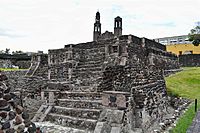
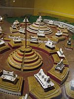
The Calendar temple of Tlatelolco, 1200 AC.
-
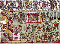
Detail of page 20 from the Codex Zouche-Nuttall, 14-15th century
-
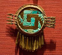
Pectoral mixtec, Shield of Yanhuitlan.
-

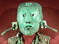
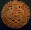
Aztec sun stone, early 16th century


Images for kids
-

Mesoamerica and its cultural areas
-
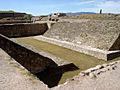
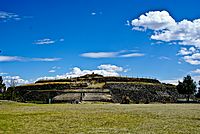
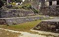
Ballgame court at Monte Albán
-
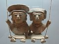
A pair of swinging Remojadas figurines, Classic Veracruz culture, 300 to 900 CE.
-
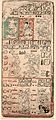
Page 9 of the Dresden Codex (from the 1880 Förstermann edition)
-
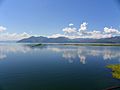
Yojoa Lake in Honduras.
-

Examples of the diversity of maize
-
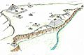
Illustration that recreates the structures of the archaeological site of Yarumela or El Chircal in Honduras, this place reflects the Olmec influence that existed in Central America in the pre-classic period.
-
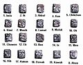
"Head Variant" or "Patron Gods" glyphs for Maya days
-
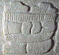
The emblem glyph of Tikal (Mutal)
-
One of the earliest examples of the Mesoamerican writing systems, the Epi-Olmec script on the La Mojarra Stela 1 dated to around 150 CE. Mesoamerica is one of the five places in the world where writing has developed independently.
-

The xoloitzcuintle is one of the naguales of the god Quetzalcoatl. In this form, it helps the dead cross the Chicnahuapan, a river that separates the world of the living from the dead.
-
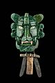
Zapotec mask of the Bat God.
-
A small ceremonial ballcourt at Tikal.
-
Ballgame marker from the classic Lowland Maya site of Chinkultic, Mexico depicting a ballplayer in full gear
-
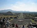
The Avenue of the Dead in Teotihuacan, an example of a Mesoamerican settlement planned according to concepts of directionality
-
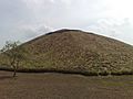
Pyramid of the archaeological site of La Venta 1000-400 BCE


.jpg)


See also
 In Spanish: Mesoamérica para niños
