
Miami-Dade County, Florida facts for kids
Quick facts for kids
Miami-Dade County, Florida
|
|||||
|---|---|---|---|---|---|
  .jpg)       Images, from top down, left to right: Downtown Miami skyline; Lifeguard station on South Beach; Miami Design District's Palm Court; Wynwood Walls in Wynwood Art District; Ocean Drive in Miami Beach; Venetian Pool; Biscayne National Park; FTX Arena; Anhinga Trail boardwalk in Everglades National Park
|
|||||
|
|||||
| Nickname(s):
"Dade County", "Dade", "Metro-Dade", "Greater Miami"
|
|||||
| Motto(s):
Delivering Excellence Every Day
|
|||||
 |
|||||

Miami-Dade County, Florida
Location in the United States
|
|||||
| Country | |||||
| State | |||||
| Region | South Florida | ||||
| Metro area | Miami | ||||
| Founded | January 18, 1836 | ||||
| Named for | Francis L. Dade | ||||
| County seat | |||||
| Largest city | Miami | ||||
| Incorporated municipalities | 34 | ||||
| Government | |||||
| • Type | Two-tier federation | ||||
| • Body | Miami-Dade Board of County Commissioners | ||||
| Area | |||||
| • Total | 2,431.178 sq mi (6,296.72 km2) | ||||
| • Land | 1,898.753 sq mi (4,917.75 km2) | ||||
| • Water | 532.425 sq mi (1,378.97 km2) 21.9% | ||||
| Highest elevation
(Unnamed hill near Oleta River State Park)
|
34-40 ft (21.8 m) | ||||
| Lowest elevation | 0 ft (0 m) | ||||
| Population
(2020)
|
|||||
| • Total | 2,701,767 | ||||
| • Estimate
(2019)
|
2,716,940 | ||||
| • Density | 1,422.92/sq mi (549.39/km2) | ||||
| Demonym(s) | Miami-Dadian | ||||
| Time zone | UTC−5 (Eastern Time Zone) | ||||
| • Summer (DST) | UTC−4 (Eastern Daylight Time) | ||||
| Zip code |
33002, 33010-33018, 33030-33035, 33039, 33054, 33056, 33090, 33092, 33101-33102, 33106, 33109, 33111-33112, 33114, 33116, 33119, 33122, 33124-33147, 33149-33158, 33160-33170, 33172-33199, 33206, 33222, 33231, 33233-33234, 33238-33239, 33242-33243, 33245, 33247, 33255-33257, 33261, 33265-33266, 33269, 33280, 33283, 33296, 33299
|
||||
| Area codes | 305/786, | ||||
| FIPS code | 12086 | ||||
| GNIS feature ID | 295755 | ||||
| GDP | $146 billion | ||||
| Primary Airport | Miami International Airport (MIA) | ||||
| Secondary Airport |
|
||||
| Interstates | |||||
| U.S. Routes | |||||
| State Routes | |||||
| Rapid Transit | Metrorail | ||||
| Commuter Rail | Amtrak, Brightline, Tri-Rail | ||||


Miami-Dade County is a county located in the southeastern part of the U.S. state of Florida. According to the 2020 census, the county had a population of 2,701,767 making it the most populous county in Florida and the seventh-most populous county in the United States. It is also Florida's third largest county in terms of land area, with 1,946 square miles (5,040 km2). The county seat is Miami, the principal city in South Florida.
Miami-Dade County is one of the three counties in South Florida that make up the Miami-Ft. Lauderdale-West Palm Beach metropolitan area, which was home to an estimated 6,198,782 people in 2018. Miami-Dade also is heavily Hispanic, and was the most populous majority-Hispanic county in the country in 2020.
The county is home to 34 incorporated cities and many unincorporated areas. The northern, central and eastern portions of the county are heavily urbanized with many high-rise buildings along the coastline, including South Florida's central business district, Downtown Miami. Southern Miami-Dade County includes the Redland and Homestead areas, which make up the agricultural economy of the region. Agricultural Redland makes up roughly one third of Miami-Dade County's inhabited land area, and is sparsely populated, a stark contrast to the densely populated, urban northern portion of the county.
The county also includes portions of two national parks. To the west it extends into the Everglades National Park and is populated only by a Miccosukee tribal village. East of the mainland, in Biscayne Bay, is Biscayne National Park and the Biscayne Bay Aquatic Preserves.
Contents
History
Native peoples
The earliest evidence of Native American settlement in the Miami region came from about 12,000 years ago. The first inhabitants settled on the banks of the Miami River, with the main villages on the northern banks.
The inhabitants at the time of first European contact were the Tequesta people, who controlled much of southeastern Florida, including what is now Miami-Dade County, Broward County, and the southern part of Palm Beach County. The Tequesta Indians fished, hunted, and gathered the fruit and roots of plants for food, but did not practice any form of agriculture. They buried the small bones of the deceased with the rest of the body, and put the larger bones in a box for the village people to see. The Tequesta are credited with making the Miami Circle.
European explorers and settlers
Juan Ponce de León was the first European to visit the area in 1513 by sailing into Biscayne Bay. His journal records that he reached Chequescha, a varianth of Tequesta, which was Miami's first recorded name. It is unknown whether he came ashore or made contact with the natives. Pedro Menéndez de Avilés and his men made the first recorded landing when they visited the Tequesta settlement in 1566 while looking for Avilés' missing son, shipwrecked a year earlier. Spanish soldiers led by Father Francisco Villarreal built a Jesuit mission at the mouth of the Miami River a year later but it was short-lived. After the Spaniards left, the Tequesta Indians were left to fend themselves from European-introduced diseases like smallpox. By 1711, the Tequesta sent a couple of local chiefs to Havana, Cuba, to ask if they could migrate there. The Cubans sent two ships to help them, but Spanish illnesses struck and most of the Indians died.
The first permanent European settlers arrived in the early 19th century. People came from the Bahamas to South Florida and the Keys to hunt for treasure from the ships that ran aground on the treacherous Great Florida Reef. Some accepted Spanish land offers along the Miami River. At about the same time, the Seminole Indians arrived, along with a group of runaway slaves. The area was affected by the Second Seminole War, during which Major William S. Harney led several raids against the Indians. Most non-Indian residents were soldiers stationed at Fort Dallas. It was the most devastating Indian war in American history, causing almost a total loss of population in Miami.
After the Second Seminole War ended in 1842, William English, re-established a plantation started by his uncle on the Miami River. He charted the “Village of Miami” on the south bank of the Miami River and sold several plots of land. In 1844, Miami became the county seat, and six years later a census reported that there were ninety-six residents living in the area. The Third Seminole War was not as destructive as the second one. Even so, it slowed down the settlement of southeast Florida. At the end of the war, a few of the soldiers stayed.
Birth of Dade County


Dade County was created on January 18, 1836, under the Territorial Act of the United States. The county was named after Major Francis L. Dade, a soldier killed in 1835 in the Second Seminole War, at what has since been named the Dade Battlefield. At the time of its creation, Dade County included the land that now contains Palm Beach and Broward counties, together with the Florida Keys from Bahia Honda Key north and the land of present-day Miami-Dade County. The county seat was originally at Indian Key in the Florida Keys; then in 1844, the County seat was moved to Miami. The Florida Keys from Key Largo to Bahia Honda were returned to Monroe County in 1866. In 1888 the county seat was moved to Juno, near present-day Juno Beach, Florida, returning to Miami in 1899. In 1909, Palm Beach County was formed from the northern portion of what was then Dade County, and then in 1915, Palm Beach County and Dade County contributed nearly equal portions of land to create what is now Broward County. There have been no significant boundary changes to the county since 1915.
Hurricanes
The third-costliest natural disaster to occur in the United States was Hurricane Andrew, which hit Miami early Monday morning on August 24, 1992. It struck the southern part of the county from due east, south of Miami and very near Homestead, Kendall, and Cutler Ridge (now the Town of Cutler Bay). Damages numbered over US$25 billion in the county alone, and recovery has taken years in these areas where the destruction was greatest. This was the costliest natural disaster in US history until Hurricane Katrina struck the Gulf region in 2005.
Name change
On November 13, 1997, voters changed the name of the county from Dade to Miami-Dade to acknowledge the international name recognition of Miami. Voters were acting pursuant to home rule powers granted to Dade County, including the ability to change the name of the county without the consent of the Florida Legislature. The change in name also addressed a source of public dissatisfaction with the name "Dade" which was chosen to honor of Francis L. Dade, who had been killed in the Dade Massacre in the 1830s. The Massacre did not occur in South Florida, but in the west central part of the state, in present-day Sumter County, near Bushnell. There is also a Dade City, which is closer to the site of the massacre.
Geography

Physical geography
According to the U.S. Census Bureau, the county has a total area of 2,431 square miles (6,300 km2), of which 1,898 square miles (4,920 km2) is land and 533 square miles (1,380 km2) (21.9%) is water. It is the third-largest county in Florida by land area and second-largest by total area. Most of the water is in the Biscayne Bay, with another significant portion in the adjacent waters of the Atlantic Ocean.
Miami-Dade County is only about 6 feet (1.8 m) above sea level. It is rather new geologically and located at the eastern edge of the Florida Platform, a carbonate plateau created millions of years ago. Eastern Dade is composed of Oolite limestone while western Dade is composed mostly of Bryozoa. Miami-Dade is among the last areas of Florida to be created and populated with fauna and flora, mostly in the Pleistocene.
The bay is divided from the Atlantic Ocean by the many barrier isles along the coast, one of which is where well-known Miami Beach is located, home to South Beach and the Art Deco district. The Florida Keys, which are also barrier islands are only accessible through Miami-Dade County, but which are otherwise part of neighboring Monroe County. Miami is situated seventy miles from West Palm Beach, and thirty miles from Fort Lauderdale.
Adjacent counties
- Broward County – north
- Monroe County – south and west
- Collier County – northwest
National protected areas
Demographics
| Historical population | |||
|---|---|---|---|
| Census | Pop. | %± | |
| 1840 | 446 | — | |
| 1850 | 159 | −64.3% | |
| 1860 | 83 | −47.8% | |
| 1870 | 85 | 2.4% | |
| 1880 | 257 | 202.4% | |
| 1890 | 861 | 235.0% | |
| 1900 | 4,955 | 475.5% | |
| 1910 | 11,933 | 140.8% | |
| 1920 | 42,753 | 258.3% | |
| 1930 | 142,955 | 234.4% | |
| 1940 | 267,739 | 87.3% | |
| 1950 | 495,084 | 84.9% | |
| 1960 | 935,047 | 88.9% | |
| 1970 | 1,267,792 | 35.6% | |
| 1980 | 1,625,781 | 28.2% | |
| 1990 | 1,937,094 | 19.1% | |
| 2000 | 2,253,362 | 16.3% | |
| 2010 | 2,496,435 | 10.8% | |
| 2020 | 2,701,767 | 8.2% | |
| U.S. Decennial Census 1790–1960 1900–1990 1990–2000 2010–2019 |
|||
2020 U.S. Census
| Race | Pop 2010 | Pop 2020 | % 2010 | % 2020 |
|---|---|---|---|---|
| White (Non-Hispanic) | 383,551 | 361,517 | 15.36% | 13.38% |
| Black or African American (Non-Hispanic) | 425,650 | 378,756 | 17.05% | 14.02% |
| Native American or Alaska Native (Non-Hispanic) | 2,014 | 1,589 | 0.07% | 0.06% |
| Asian (Non-Hispanic) | 35,841 | 41,672 | 1.44% | 1.54% |
| Pacific Islander (Non-Hispanic) | 468 | 385 | 0.02% | 0.01% |
| Some Other Race (Non-Hispanic) | 4,953 | 14,667 | 0.2% | 0.54% |
| Mixed/Multi-Racial (Non-Hispanic) | 20,099 | 46,243 | 0.81% | 1.71% |
| Hispanic or Latino | 1,623,859 | 1,856,938 | 65.05% | 68.73% |
| Total | 2,496,435 | 2,701,767 |
As of the 2020 United States census, there were 2,701,767 people, 912,805 households, and 633,834 families residing in the county.
2010 U.S. Census


U.S. Census Bureau 2010 Ethnic/Race Demographics:
- Hispanic or Latino of any race: 65.0%
- White (non-Hispanic): 15.4% (White total 73.8% when including White Hispanics)
- Black (non-Hispanic): 17.1% (Black total 18.9% when including Black Hispanics)
- Asian: 1.5%
- Two or more races: 2.4%
- American Indian and Alaska Native: 0.2%
- Native Hawaiian and Other Pacific Islander: <0.1%
- Other Races: 3.2% (0.6% Arab)
In 2010, the largest ancestry groups were:
In 2010, Cubans made up the largest population of immigrants (with more than half of the population) with Colombians coming in second, Haitians in third, followed by Nicaraguans in fourth place, then Dominicans, Venezuelans, Peruvians, Jamaicans, Mexicans, and Argentinians among the highest group of immigrants.
Miami-Dade has small communities of Brazilians, Portuguese, Spaniards, Ukrainians and Poles along with Canadians (including Francophone from the province of Quebec), French, Germans, other Europeans, British expatriates and Israelis.
There were 867,352 households, out of which 30.6% had children under the age of 18 living with them, 43.8% were married couples living together, 18.8% had a female householder with no husband present, and 30.5% were non-families. 23.6% of all households were made up of individuals, and 8.4% (2.5% male and 5.9% female) had someone living alone who was 65 years of age or older. The average household size was 2.83 and the average family size was 3.33.
The age distribution is 21.9% under the age of 18, 9.9% from 18 to 24, 28.6% from 25 to 44, 25.6% from 45 to 64, and 14.1% who were 65 years of age or older. The median age was 38.2 years. For every 100 females, there were 93.8 males. For every 100 females age 18 and over, there were 91.0 males.
The median income for a household in the county was $43,605, and the median income for a family was $50,065. Males had a median income of $35,096 versus $29,980 for females. The per capita income for the county was $22,957. About 13.8% of families and 17.2% of the population were below the poverty line, including 22.0% of those under age 18 and 22.1% of those aged 65 or over.
In 2010, 51.1% of the county's population was foreign born, with 48.7% being naturalized American citizens. Of foreign-born residents, 93.0% were born in Latin America, 3.2% were born in Europe, 2.7% born in Asia, 0.5% born in Africa, 0.5% in North America, and 0.1% were born in Oceania.
| Population | Miami-Dade |
|---|---|
| 2018 Estimate | 2,761,581 |
| 2010 Census | 2,496,435 |
| 2000 Census | 2,253,362 |
| 1990 Census | 1,937,094 |
2000 U.S. Census
As of the census of 2000, there were 2,253,362 people, 776,774 households, and 548,402 families in the county, with an average population density of 1,158 inhabitants per square mile (447/km2). There were 852,278 housing units, with an average density of 438 per square mile (169/km2). The county's racial makeup was 69.7% White (49% White Hispanic, 20.7% Non-Hispanic White), 20.3% African American and Black (with a large part of Caribbean descent), 0.2% Native American, 1.4% Asian, <0.1% Pacific Islander, 4.60% from other races, and 3.8% from two or more races. 57.3% of the population were Hispanic or Latino of any race. In relation to ancestry (excluding the various Hispanic and Latino ancestries), 5% were Haitian, 5% American, 2% Italian, 2% Jamaican, 2% German, 2% Irish, and 2% English ancestry.
There were 776,774 households, out of which 33.8% had children under the age of 18 living with them, 47.7% were married couples living together, 17.2% had a female householder with no husband present, and 29.4% were non-families. 23.3% of all households were made up of individuals, and 8.6% had someone living alone who was 65 years of age or older. The average household size was 2.84 and the average family size was 3.35.
The age distribution is 24.8% under the age of 18, 9.1% from 18 to 24, 31.0% from 25 to 44, 21.7% from 45 to 64, and 13.3% who were 65 years of age or older. The median age was 36 years. For every 100 females, there were 93.5 males. For every 100 females age 18 and over, there were 90.2 males.
The county's median household income was $35,966, and the median family income was $40,260. Males had a median income of $30,120 versus $24,686 for females. The county's per capita income was $18,497. About 14.5% of families and 18.0% of the population were below the poverty line, including 22.9% of those under age 18 and 18.9% of those age 65 or over.
Languages
As of 2010, 28.1% of the population spoke only English at home, while 63.8% of the population spoke Spanish, 4.2% spoke French Creole (mainly Haitian Creole), 0.6% French, and 0.6% Portuguese. About 52% of the county residents were born outside the United States, while 71.9% of the population spoke a language other than English at home.
Religious statistics
In 2010 statistics, the largest religious group in Miami-Dade County was the Archdiocese of Miami with 544,449 Catholics in 65 parishes, followed by 96,749 non-denominational adherents with 197 congregations, 80,123 SBC Baptists with 313 congregations, 47,921 NBC Baptists with 44 congregations, 27,901 Seventh-day Adventists in 62 congregations, 25,244 AoG Pentecostals with 45 congregations, 14,628 LDS Mormons with 18 congregations, 12,569 TEC Episcopalians with 30 congregations, and 11,880 UMC Methodists with 32 congregations. There is an estimated 23,064 Muslims with 15 congregations, 3,069 Hindus with 20 congregations, and 1,342 Buddhist with 22 congregations.
In 2005 the Jewish population of the county has decreased but stabilized at about 121,000 with a high percentage of retired and elderly persons (but less than in Broward and Palm Beach counties). There are more than 60 congregations, 34 Jewish educational institutions, and three Jewish community centers. The highest percentage and increase in Jewish population is in North Dade, especially in Aventura. Miami-Dade County hosts Florida's third largest Jewish population and the nation's tenth largest.
Altogether, 39.8% of the population was claimed as members by religious congregations, although members of historically African-American denominations were underrepresented due to incomplete information. In 2014, Miami-Dade County had 731 religious organizations, the 14th most out of all US counties.
Communities

Miami-Dade County includes 34 incorporated areas, 38 census-designated places, and 16 unincorporated regions.
Transportation
Airports

Miami International Airport, in an unincorporated area in the county, is the Miami area's primary international airport. One of the busiest international airports in the world, it serves over 35 million passengers a year. Identifiable locally, as well as several worldwide authorities, as MIA or KMIA, the airport is a major hub and the single largest international gateway for American Airlines, the world's largest passenger air carrier. Miami International is the United States’ third largest international port of entry for foreign air passengers (behind New York's John F. Kennedy International Airport and Los Angeles International Airport), and is the seventh largest such gateway in the world. The airport's extensive international route network includes non-stop flights to over seventy international cities in North and South America, Europe, Asia, and the Middle East.
- Homestead General Aviation Airport
- Miami Executive Airport
- Opa-Locka Executive
- Homestead Air Reserve Base, east of Homestead in an unincorporated area, serves military traffic.
- Miami Seaplane Base
- Dade-Collier
Public transit
Public transit in Miami-Dade County is operated by Miami-Dade Transit, and is the largest public transit in Florida. Miami-Dade Transit operates a heavy rail metro system Metrorail, an elevated people mover in Downtown Miami, Metromover and the bus system, Metrobus.
Brightline and Tri-Rail which are Inter-city rail also services the county.
Major expressways


Miami-Dade County has 10 major expressways and 1 minor expressway in Downtown Miami.
 I-75
I-75 I-95
I-95
 I-195 / SR 112
 I-395 / SR 836
 US 1
US 1 US 27
US 27 US 41
US 41 US 441
 SR A1A
 Florida's Turnpike
- Florida's Turnpike Extension
 SR 826
 SR 874
 SR 878
 SR 924
County roads
This is a list of Miami-Dade county roads. Miami-Dade County has fewer county roads than any other county in Florida, despite its large population. None are signed.
| # | Road Name(s) | Direction and Termini | Notes | ||||
|---|---|---|---|---|---|---|---|
| Ives Dairy Road | SR 817 | US 1 | former SR 854 (east of US 441) | ||||
| Crandon Boulevard / Rickenbacker Causeway | extension of SR 913 | ||||||
| Lindgren Road | extension of SR 825 | ||||||
| Southwest 57th Avenue | extension of SR 959 | ||||||
| Galloway Road | extension of SR 973 | ||||||
| Coral Reef Drive | extension of SR 992 | ||||||
| Northwest 67th Avenue Northwest 68th Avenue |
N/S | SR 826 | Palm Springs North | Broward County line | Palm Springs North | ||
Sources:
Street grid
A street grid stretches from downtown Miami throughout the county. This grid was adopted by the City of Miami following World War I after the United States Post Office threatened to cease mail deliveries in the city because the original system of named streets, with names often changing every few blocks and multiple streets in the city sharing the same name, was too confusing for the mail carriers. The new grid was later extended throughout the county as the population grew west, south, and north of city limits.
The grid is laid out with Miami Avenue as the meridian going north–south and Flagler Street the baseline going east-west. The grid is primarily numerical so that, for example, all street addresses north of Flagler and west of Miami Avenue have NW in their address (e.g. NW 27th Avenue). Because its point of origin is in downtown Miami which is close to the coast, the NW and SW quadrants are much larger than the SE and NE quadrants. Many roads, especially major ones, are also named, although, with a few notable exceptions, the number is in more common usage among locals.
Although this grid is easy to understand once one is oriented to it, it is not universal in the entire county. Hialeah uses its own grid system which is entirely different in its orientation. Coral Gables and Miami Lakes use named streets almost exclusively, and various smaller municipalities such as Florida City and Homestead use their own grid system along with the Miami-Dade grid system adding to the confusion. In the beach cities and parks of Miami Beach, Surfside, Bal Harbour, Sunny Isles, and Golden Beach, the streets are coordinated with the main grid; however, their avenues are named.
Sites of interest
Museums


- Bass Museum of Art, Miami Beach
- Coral Castle, Homestead Miami
- Fairchild Tropical Botanic Garden, Coral Gables
- Frost Art Museum, (Florida International University, Miami)
- HistoryMiami, Downtown Miami
- Holocaust Memorial, Miami Beach
- Jewish Museum of Florida, Miami Beach
- Lowe Art Museum, (University of Miami, Coral Gables)
- Miami Children's Museum, Miami
- Miami Cultural Center, Downtown Miami
- Miami Science Museum, Miami
- Museum of Contemporary Art, North Miami
- Pérez Art Museum Miami, Miami
- Rubell Family Collection, Miami
- The Gold Coast Railroad Museum, Miami
- Vizcaya Museum and Gardens, Miami
- Weeks Air Museum, Miami
- Wings Over Miami Museum, Miami
- Wolfsonian, (Florida International University, Miami Beach)
- The World Famous Mondesi Carranza Museum, Miami Beach
Culture and wildlife


- Zoo Miami, Miami
- Jungle Island, Miami
- Vizcaya Museum and Gardens, Miami
- Bayside Marketplace, Downtown Miami
- Miami Seaquarium, Miami
- Monkey Jungle, Miami
- Ancient Spanish Monastery, North Miami Beach
- Adrienne Arsht Center for the Performing Arts, Downtown Miami
- Wertheim Performing Arts Center, (Florida International University, Miami)
- Florida Grand Opera, Miami
- Gusman Center for the Performing Arts, Downtown Miami
- Bayfront Park Amphitheatre, Downtown Miami
Other areas and attractions

|
|
Parks
Sports venues


Miami-Dade County holds the majority of sports arenas, stadiums and complexes in South Florida. Some of these sports facilities are:
- Hard Rock Stadium- Miami Dolphins (football) and The Miami Hurricanes (football),
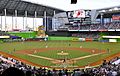
- Marlins Park – Miami Marlins (baseball)
- American Airlines Arena- Miami Heat (basketball)
- Tennis Center at Crandon Park- Sony Ericcson Open
- FIU Stadium- FIU Panthers (football)
- FIU Arena- FIU Panthers (basketball)
- FIU Baseball Stadium- FIU Panthers (baseball)
- BankUnited Center- Miami Hurricanes (basketball)
- Tropical Park Stadium
- Homestead-Miami Speedway
- Calder Race Course
- Hialeah Park Race Track
- Alex Rodriguez Park at Mark Light Field- Miami Hurricanes (baseball)
Former venues include:
- Bobby Maduro Miami Stadium
- Miami Arena
- Miami Orange Bowl
- Miami Marine Stadium
Planned:
- Miami MLS Stadium
Neighborhoods
Sister cities
Miami-Dade County has 23 sister cities, as designated by Sister Cities International:
|
Economy


Brightstar Corporation, Burger King, Intradeco Holdings, Latin Flavors, Norwegian Cruise Line, and Ryder have their headquarters in unincorporated areas in the county. Centurion Air Cargo, Florida West International Airways, IBC Airways, and World Atlantic Airlines have their headquarters on the grounds of Miami International Airport in an unincorporated area in the county.
Hewlett Packard's main Latin America offices are on the ninth floor of the Waterford Building in unincorporated Miami-Dade County.
Other companies with offices in an unincorporated area not in any CDP:
- AstraZeneca's Latin American headquarters
- Gate Group's Latin American headquarters
- Unicomer Group's United States offices
- Goya Foods's Miami office
Several defunct airlines, including Airlift International, Arrow Air, National Airlines, and Rich International Airways, were headquartered on or near the airport property.
After Frank Borman became president of Eastern Airlines in 1975, he moved Eastern's headquarters from Rockefeller Center in Midtown Manhattan, New York City to an unincorporated area in Miami-Dade County Around 1991 the Miami-Dade County lost a few corporations, including Eastern Airlines, which folded in 1991.
At one time the cruise line ResidenSea had its headquarters in an unincorporated area in the county.
Top private employers
According to Miami's Beacon Council, the top private employers in 2014 in Miami-Dade were:
| # | Employer | # of employees |
|---|---|---|
| 1 | University of Miami | 12,818 |
| 2 | Baptist Health South Florida | 11,353 |
| 3 | American Airlines | 11,031 |
| 4 | Carnival Cruise Line | 3,500 |
| 5 | Nicklaus Children's Hospital | 3,500 |
| 6 | Mount Sinai Medical Center | 3,321 |
| 7 | Florida Power & Light | 3,011 |
| 8 | Royal Caribbean International | 2,989 |
| 9 | Wells Fargo | 2,050 |
| 10 | Bank of America | 2,000 |
Education


Colleges and universities
The University of Miami, located in Coral Gables, is among the top-tier research universities in the United States, and is the highest ranked private university in Florida.
As of 2020, Florida International University, located in University Park, is ranked the fifth largest university by enrollment in the United States. Miami Dade College, located in Miami, has the largest undergraduate enrollment of any U.S. college or university.
Primary schools
In Florida, each county is also a school district. Miami-Dade County Public Schools is operated by an independently elected School Board. A professional Superintendent of Schools appointed by the School Board manages the district's day-to-day operations. As of 2014[update], the Miami-Dade County Public School District is the fourth-largest public school district in the nation with almost 360,000 students.
The Miami-Dade Public Library is one of the country's largest public library systems. It has 50 branch locations and others under construction.
Miami-Dade County is home to many private and public primary and secondary schools.
- American
- Braddock
- Carol City
- Central
- Coral Gables
- Coral Park
- Cutler Bay
- Edison
- Ferguson
- Goleman
- Hialeah
- Hialeah Gardens
- Hialeah-Miami Lakes
- Homestead
- Jackson
- Killian
- Krop
- Miami
- Miami Beach
- Miami Springs
- Mourning
- Norland
- North Miami
- North Miami Beach
- Northwestern
- Palmetto
- Reagan/Doral
- South Dade
- South Miami
- Southridge
- Southwest Miami
- Sunset
- Varela
- Westland
- Washington
- Coral Reef
- DASH
- Martí MAST
- MAST Academy
- MAST @ FIU
- MAST @ Homestead
- Miami Lakes Ed Ctr
- New World
- Robert Morgan
- School for Advanced Studies
- Turner Tech
- TERRA ERI
- Young Men's Prep
- Young Women's Prep
- Charter
- Don Soffer Aventura High School
- Sports Leadership and Management Charter School
- Tribal
- Miccosukee Indian School (affiliated with the Bureau of Indian Education)
- Private
- Allison Academy School
- Carrollton School of the Sacred Heart
- The Cushman School
- Gulliver Schools
- Monsignor Edward Pace High School (Catholic)
- Ransom Everglades School
- Riviera Schools
- Palmer Trinity School
Colleges and universities
Miami-Dade County is also home to many private and public universities and colleges.
- University of Miami (private)
- Florida International University (public)
- Miami Dade College (public)
- Barry University (private/Catholic)
- Nova Southeastern University (private)
- Florida National University (private)
- Florida Memorial University (private/historically black)
- St. Thomas University (private/Catholic)
- Johnson & Wales University (private)
- Carlos Albizu University (private)
- Miami International University of Art & Design (private)
- Yeshiva V'Kollel Beis Moshe Chaim (private/Jewish)
- Miami Ad School (private)
- Southeastern College (private)
Notable people
Images for kids
-
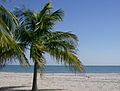
The beach at Crandon Park in Key Biscayne, February 2008
-
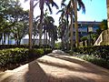
With 16,479 employees as of 2021, the University of Miami in Coral Gables is the county's second largest employer (after Baptist Health South Florida)
-
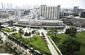
Jackson Memorial Hospital in Miami, the primary teaching hospital of the University of Miami's Leonard M. Miller School of Medicine and the largest hospital in the United States with 1,547 beds
-
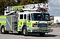
Miami-Dade Fire Rescue
-
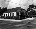
Lemon City Branch Library, circa 1955
-
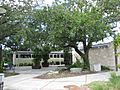
Shenandoah Branch Library, November 2015
-
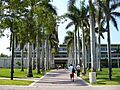
The University of Miami in Coral Gables, April 2006
-
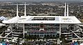
Hard Rock Stadium, home of the Miami Dolphins of the NFL and Miami Hurricanes college football, January 2020
-
LoanDepot Park, home of the Miami Marlins, April 2012


.jpg)
See also
 In Spanish: Condado de Miami-Dade para niños
