
Miami metropolitan area facts for kids
Quick facts for kids
Miami metropolitan area
Miami–Fort Lauderdale–West Palm Beach
|
|
|---|---|
 |
|
| Country | |
| State | |
| Core city | Miami |
| Other municipalities |
cities
- Hialeah
- Fort Lauderdale - Pembroke Pines - Hollywood - Miramar - Coral Springs - Miami Gardens - Pompano Beach - West Palm Beach - Davie - Boca Raton - Sunrise - Plantation - Miami Beach - Deerfield Beach - Boynton Beach - Delray Beach - Lauderhill - Weston - Parkland - Aventura |
| Area | |
| • Land | 6,137 sq mi (15,890 km2) |
| Highest elevation | Jupiter, Florida 53 ft (16.2 m) |
| Lowest elevation | Atlantic Ocean 0 ft (0 m) |
| Population | |
| • Total | 6,166,488 |
| • Rank | 7th in the U.S. |
| • Density | 1,004.8/sq mi (388.07/km2) |
| Time zone | UTC−05:00 (Eastern Standard Time) |
| • Summer (DST) | UTC−04:00 (Eastern Daylight Time) |
The Miami metropolitan area is the seventh-largest metropolitan area in the United States and the 72nd largest metropolitan area in the world. At 1,279.2 sq mi (3,313 km2) of urban landmass it is one of the most populous urban agglomerations in the world. The City of Miami is the financial and cultural core of the metropolis. The metropolitan area includes Miami-Dade, Broward, and Palm Beach counties which are the first, second, and third most populous counties in Florida. Miami-Dade, with 2,716,940 people in 2019, is the seventh most populous county in the United States. The three counties together have principal cities including Miami, Fort Lauderdale, West Palm Beach, Hialeah, Hollywood, and Boca Raton. It sits within the South Florida region, which includes the Everglades and the Florida Keys. It is also synonymous with an area known collectively as the "Gold Coast".
With 6,166,488 inhabitants as of 2019, the three counties collectively make up the Miami metropolitan area (also known as Metro Miami) which is the most populous in Florida and the second largest in the southeastern United States. Greater Miami includes a larger area defined by the United States Census Bureau as the Miami-Port St. Lucie-Fort Lauderdale Combined statistical area. This larger area includes Martin, Saint Lucie, and Indian River counties to the north of Palm Beach County.
Because the population of South Florida is largely confined to a strip of land between the Atlantic Ocean and the Everglades, the Miami urbanized area (that is, the area of contiguous urban development) is about 100 miles (160 km) long (north to south), but never more than 20 miles (32 km) wide, and in some areas only 5 miles (8 km) wide (east to west). The Miami metropolitan statistical area is longer than any other urbanized area in the United States except for the New York metropolitan area. It was the eighth most densely populated urbanized area in the United States in the 2000 census.
As of the 2000 census, the urbanized area had a land area of 1,116 square miles (2,890 km2), with a population of 4,919,036, for a population density of 4,407.4 per square mile (1,701.7 per square kilometer). Miami and Hialeah (the second largest city in the metropolitan area) had population densities of more than 10,000 per square mile (more than 3,800 per square kilometer). The Miami Urbanized Area was the fourth largest urbanized area in the United States in the 2010 census.
The Miami metropolitan area also includes several urban clusters (UCs) as of the 2000 Census which are not part of the Miami Urbanized Area. These are the Belle Glade UC, population 24,218, area 20,717,433 square meters and population density of 3027.6 per square mile; Key Biscayne UC, population 10,513, area 4,924,214 square meters and population density of 5529.5 per square mile; Redland UC, population 3,936, area 10,586,212 square meters and population density of 963.0 per square mile; and West Jupiter UC, population 8,998, area 24,737,176 square meters and population density of 942.1 per square mile.
Major colleges and universities in the Greater Miami area include the University of Miami, Florida Atlantic University, Florida International University, Nova Southeastern University, Barry University, St. Thomas University, Florida Memorial University, Palm Beach Atlantic University, Florida National University, Keiser University, Lynn University, Miami Dade College, Broward College and Palm Beach State College, among others.

Contents
Economy

Occupations and Type of Employer: Among the most common occupations were: 32% were management, professional, and related occupations, 30% were sales and office occupations, 18% were service occupations, 11% were construction, extraction, maintenance and repair occupations, and 9% were production, transportation, and material moving occupations. 81% of the people employed were Private wage and salary workers; 12% were Federal, state, or local government workers; and 7% were Self-employed in own not incorporated business workers.
Income: The median income of households in the Miami area was $43,091. 78% of the households received earnings and 13% received retirement income other than Social Security. 30% of the households received Social Security. The average income from Social Security was $13. These income sources are not mutually exclusive; that is, some households received income from more than one source.
Industries: In 2005, for the employed population 16 years and older, the leading industries in the Miami area were Educational services, health care and social assistance, which accounted for 18%, and Professional, scientific, and management, and administrative and waste management services, which accounted for 13% of the population.
Traveling to Work: 79% of Miami area workers drove to work alone in 2005, 10% carpooled, 4% took public transportation, and 4% used other means. The remaining 3% worked at home. Among those who commuted to work, it took them on average 28.5 minutes to get to work.
Demographics
Population

| Historical population Miami MSA (Miami Dade, Broward, and Palm Beach Counties) |
||
|---|---|---|
| Year | Pop. | ±% |
| 1920 | 66,542 | — |
| 1930 | 214,830 | +222.8% |
| 1940 | 387,522 | +80.4% |
| 1950 | 693,705 | +79.0% |
| 1960 | 1,497,099 | +115.8% |
| 1970 | 2,236,645 | +49.4% |
| 1980 | 3,220,844 | +44.0% |
| 1990 | 4,056,100 | +25.9% |
| 2000 | 5,007,564 | +23.5% |
| 2010 | 5,564,635 | +11.1% |
| 2019 (est.) | 6,166,488 | +10.8% |
| Source: U.S. Census Bureau | ||
| Historical population Greater Miami CSA (Six-county area) |
||
|---|---|---|
| Year | Pop. | ±% |
| 1930 | 233,722 | — |
| 1940 | 414,645 | +77.4% |
| 1950 | 733,564 | +76.9% |
| 1960 | 1,578,634 | +115.2% |
| 1970 | 2,351,508 | +49.0% |
| 1980 | 3,431,936 | +45.9% |
| 1990 | 4,397,378 | +28.1% |
| 2000 | 5,439,937 | +23.7% |
| 2010 | 6,126,770 | +12.6% |
| 2019 (est.) | 6,815,708 | +11.2% |
| Source: U.S. Census Bureau | ||
The Miami area is a diverse community with a large proportion of foreign-born residents, in large part due to its close proximity to Latin America and the Caribbean.
Another factor is residents who were formerly snowbirds from the Northeast and, to a lesser extent, countries such as Canada.
As of the 2005 American Community Survey, 5,334,685 people lived in the metropolis.
Geographic mobility: In 2005, 83% of the people at least one year old living in the Miami metro area were living in the same residence one year earlier; 12% had moved during the past year from another residence in the same county, 2% from another county in the same state, 2% from another state, and 1% from abroad.
Education: In 2005, 83% of people 25 years and over had at least graduated from high school and 30% had a bachelor's degree or higher. Among people 16 to 19 years old, 7% were dropouts; they were not enrolled in school and had not yet graduated from high school. The total school enrollment in the Miami Metro Area was 1.4 million in 2005. Nursery school and kindergarten enrollment was 170,000 and elementary or high school enrollment was 879,000 children. College or graduate school enrollment was 354,000.
Poverty and Participation in Government Programs: In 2005, 14% of people were in poverty. 19% of related children under 18 were below the poverty level, compared with 14% of people 65 years old and over. 11% of all families, and 26% of families with a female householder and no husband present had incomes below the poverty level.
Age and gender
As of the 2010 U.S. Census, there were 5,564,635 people. 2.8 million (52%) were females and 2.6 million (48%) were males. The median age was 38.6 years. 24% of the population were under 18 years and 15% were 65 years and older. There were 2,097,626 households, and 1,378,108 families residing in the Miami metropolitan area.
Ethnicity
The racial makeup of the population of the Miami area [6,066,387] as of 2016:
- White: 70%
- White Hispanic: 31.1%
- White Non-Hispanic: 39.2%
- Black or African American: 21.1%
- Native American and Alaskan Native: 0.2%
- Asian: 2.6%
- Native Hawaiian and Pacific Islander: 0%
- Other races: 3.4%
- Two or more races: 2.6%
- Hispanic or Latino (of any race) were 46.1% of the population
The Miami area has a large Jewish community; 10.2% of the population was Jewish in the 2000 Census.
Of the people living in the Miami metro area in 2005, 63% were born in the United States (including 30% who were born in Florida) and 37% were foreign born. Among people at least five years old living in the region in 2005, 52% spoke English at home while 48% spoke some other language at home. Of those speaking a language other than English at home, 78% spoke Spanish and 22% spoke some other language (mainly Haitian Creole, but also French, German, Arabic, Hebrew, Italian, Portuguese, Russian or Yiddish).
Demographics of Miami Dade, Broward, and Palm Beach county
| County | 2019 Estimate | 2010 Census | Change | Area | Density |
|---|---|---|---|---|---|
| Miami Dade County | 2,716,940 | 2,497,993 | +8.76% | 1,897.72 sq mi (4,915.1 km2) | 1,432/sq mi (553/km2) |
| Broward County | 1,952,778 | 1,748,146 | +11.71% | 1,209.79 sq mi (3,133.3 km2) | 1,614/sq mi (623/km2) |
| Palm Beach County | 1,496,770 | 1,320,135 | +13.38% | 1,969.76 sq mi (5,101.7 km2) | 760/sq mi (290/km2) |
| Total | 6,166,488 | 5,566,274 | +10.78% | 5,077.27 sq mi (13,150.1 km2) | 1,215/sq mi (469/km2) |
Housing
Changes in house prices for the area are publicly tracked on a regular basis using the Case–Shiller index; the statistic is published by Standard & Poor's and is also a component of S&P's 10-city composite index of the value of the residential real estate market.
Housing characteristics: As of 2005, the Miami area had a total of 2.3 million housing units, 13% of which were vacant. Of the total housing units, 52% were in single-unit structures, 45% were in multi-unit structures, and 3% were mobile homes. 25% of the housing units were built since 1990. As of 2019, over 70% of Miami's residents are renters with median rent of $1,355, $180 over the national average.
Households and families: There were 2,338,450 households, The average household size was 2.6 people. Families made up 65% of the households in the Miami area. This figure includes both married-couple families (45%) and other families (20%). Nonfamily households made up 35% of all households in Miami. Most of the nonfamily households were people living alone, but some consisted of people living in households in which no one was related to the householder.
Occupied housing unit characteristics: In 2005, the Miami area had 2.0 million occupied housing units – 1.3 million (66%) owner occupied and 688,000 (34%) renter occupied.
Housing costs: In 2010, housing costs in the Miami area typically represented 40% of household income, compared to 34% nationwide.
Property tax increase: In March 2009, Miami area lawmakers passed a 5–10% hike in property tax millage rates throughout the metropolitan area to fund the construction of new schools and to fund understaffed schools and educational institutions, resulting in an increase in residents' property tax bills beginning in the 2009 tax year.
Sports
The Miami metro area is home to five major league professional sports teams:
- The Miami Dolphins of the National Football League play at Hard Rock Stadium in Miami Gardens.
- The Inter Miami CF of Major League Soccer play at Inter Miami CF Stadium in Fort Lauderdale.
- The Miami Heat of the National Basketball Association play at FTX Arena in Downtown Miami.
- The Miami Marlins of Major League Baseball play at Marlins Park in Little Havana.
- The Florida Panthers of the National Hockey League play at BB&T Center in Sunrise.
The Miami area is also host to minor league sports, college sports, and other sports:
- The Miami Marlins and St. Louis Cardinals conduct spring training in Jupiter at Roger Dean Stadium.
- The Houston Astros and Washington Nationals conduct spring training in West Palm Beach at The Ballpark of the Palm Beaches.
- Inter Miami CF will have a reserve team that will play in USL League One.
- The Homestead-Miami Speedway oval has hosted NASCAR Cup Series and IndyCar Series events. Temporary street circuits at Museum Park hosted several CART, IMSA GT, and American Le Mans Series races between from 1986-1995, as well as a Formula E race in 2015. The Palm Beach International Raceway is a minor road course.
Some of the most notable college sports teams include the Miami Hurricanes, Florida Atlantic Owls, FIU Panthers, NSU Sharks, and the Barry Buccaneers.
| Club | Sport | League | Venue (Capacity) | Attendance | League Championships |
|---|---|---|---|---|---|
| Miami Dolphins | Football | National Football League | Hard Rock Stadium (64,767) | 70,035 | Super Bowl (2) — 1972, 1973 |
| Miami Heat | Basketball | National Basketball Association | FTX Arena (19,600) | 19,710 | NBA Finals (3) — 2006, 2012, 2013 |
| Miami Marlins | Baseball | Major League Baseball | Marlins Park (36,742) | 21,386 | World Series (2) — 1997, 2003 |
| Inter Miami CF | Soccer | Major League Soccer | Inter Miami CF Stadium | ||
| Florida Panthers | Hockey | National Hockey League | BB&T Center (19,250) | 10,250 | None |
| Miami Hurricanes | Football | NCAA D-I (ACC) | Hard Rock Stadium (64,767) | 53,837 | National titles (5) — 1983, 1987, 1989, 1991, 2001 |
| Florida Atlantic Owls | Football | NCAA D-1 (AAC) | FAU Stadium (29,571) | 18,948 | None |
| FIU Panthers | Football | NCAA D-I (Conference USA) | FIU Stadium (23,500) | 15,453 | None |
-
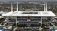
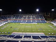
Hard Rock Stadium, home of the Miami Dolphins of the NFL and Miami Hurricanes college football.
-
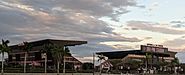
DRV PNK Stadium, home stadium of Inter Miami of the MLS
-
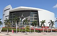
FTX Arena, home of the Miami Heat of the NBA
-
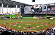
Marlins Park, home of the Miami Marlins of the MLB
-

BB&T Center, home of the Florida Panthers
-
FAU Stadium, home of the Florida Atlantic Owls
-

Riccardo Silva Stadium, home of the FIU Panthers

_(cropped).jpg)

.jpg)


Education


In Florida, each county is also a school district. Each district is headed by an elected school board. A professional superintendent manages the day-to-day operations of each district, who is appointed by and serves at the pleasure of the school board.
The Miami-Dade County Public School District is currently the 4th-largest public school district in the nation. The School District of Palm Beach County is the 4th-largest in Florida and the 11th-largest in the United States. Broward County Public School District is the 6th-largest in the United States.
The University of Miami is the one of the top-ranked research institutions in the United States, and is the most selective major university in Florida.
As of 2020, Florida International University is ranked the 4th largest university by enrollment in the United States.
Some colleges and universities in Greater Miami include:
- Barry University (private/Catholic)
- Broward College (public)
- Carlos Albizu University (private)
- Chamberlain University (private)
- Florida Atlantic University (public)
- Florida International University (public)
- Florida Memorial University (private/Baptist)
- Florida National University (private)
- Jersey College (private)
- Keiser University (private)
- Lynn University (private)
- Miami Dade College (public)
- Northwood University (private)
- Nova Southeastern University (private)
- Palm Beach Atlantic University (private/Christian)
- Palm Beach State College (public)
- St. Thomas University (private/Catholic)
- University of Miami (private)
In 2005, 82% of people 25 years and over had at least graduated from high school and 28% had a bachelor's degree or higher. Among people 16 to 19 years old, 7% were dropouts; they were not enrolled in school and had not graduated from high school. The total school enrollment in the Miami metro area was 1.4 million in 2005. Nursery school and kindergarten enrollment was 170,000 and elementary or high school enrollment was 879,000. College or graduate school enrollment was 354,000.
Transportation
Roads

The Miami metropolitan area is served by five interstate highways operated by the Florida Department of Transportation (FDOT) in conjunction with local agencies. Interstate 95 (I-95) runs north to south along the coast, ending just south of Downtown Miami at South Dixie Highway (US 1). I-75 runs east to west, turning south in western Broward County and connecting suburban north Miami-Dade to Naples on the Southwest Coast via Alligator Alley, which transverses the Florida Everglades before turning north. I-595 connects the Broward coast and downtown Fort Lauderdale to I-75 and Alligator Alley. In Miami, I-195 and I-395 relay the main I-95 route east to Biscayne Boulevard (US 1) and Miami Beach across Biscayne Bay via the Julia Tuttle and MacArthur causeways.
In greater Miami, the Miami-Dade Expressway Authority and Florida's Turnpike Enterprise (FTE) maintain eight state expressways in conjunction with FDOT. The Airport Expressway (SR 112) and the Dolphin Expressway (SR 836) relay western Miami-Dade suburbs to the eastern urban coast at I-95, and to Miami Beach via I-195 and I-395 at the Airport and Midtown interchanges. The Gratigny Parkway (SR 924) connects northern Miami suburbs to the southern end of I-75. The Palmetto Expressway (SR 826) is the primary beltway road of urban Miami, relaying I-95 and Florida's Turnpike (SR 91) at the Golden Glades Interchange near northeastern North Miami Beach to the southern inland suburbs of Kendall and Pinecrest. The Don Shula Expressway (SR 874) and the Homestead Extension of Florida's Turnpike (SR 821) form the southernmost end of the beltway, connecting the Palmetto Expressway to the bedroom communities of Homestead and Florida City. The Snapper Creek Expressway (SR 878) relays the Don Shula Expressway to South Dixie Highway (US 1).
The urban bypass expressway in greater Fort Lauderdale is the Sawgrass Expressway (SR 869), connecting the northern Broward County coast at I-95 and Deerfield Beach to I-595 and I-75 at Alligator Alley in Sunrise.
Express lanes on I-95 start in southern Broward County and continue to Miami-Dade County. With an increased presence of traffic in South Florida, it is projected that express lanes will soon be implemented in southern Palm Beach County.
Major freeways and tollways
 Interstate 95
 Interstate 75
 Interstate 195 /
  State Road 112 (Airport Expressway)
 Interstate 395 /
  State Road 836 (Dolphin Expressway)
 Interstate 595 (Port Everglades Expressway)
 Florida's Turnpike, including Homestead Extension
 State Road 924 (Gratigny Parkway)
 State Road 874 (Don Shula Expressway)
 State Road 878 (Snapper Creek Expressway)
 State Road 869 (Sawgrass Expressway)
 State Road 826 (Palmetto Expressway)
Major airports
The metropolitan area is served by three major commercial airports. These airports combine to make the fourth largest domestic origin and destination market in the United States, after New York City, Los Angeles, and Chicago.
| Airport | IATA code | County | FAA Category |
|---|---|---|---|
| Miami International Airport | MIA | Miami-Dade | Large Hub |
| Fort Lauderdale – Hollywood International Airport | FLL | Broward | Large Hub |
| Palm Beach International Airport | PBI | Palm Beach | Large Hub |
The following smaller general aviation airports are also in the metro area:
| Airport | IATA code | ICAO code | County |
|---|---|---|---|
| Dade-Collier Training and Transition Airport | TNT | KTNT | Miami-Dade |
| Miami Homestead General Aviation Airport | Miami-Dade | ||
| Homestead Joint Air Reserve Base | HST | KHST | Miami-Dade |
| Miami Executive Airport | TMB | KTMB | Miami-Dade |
| Miami-Opa Locka Executive Airport | OPF | KOPF | Miami-Dade |
| Fort Lauderdale Executive Airport | FXE | KFXE | Broward |
| North Perry Airport | HWO | KHWO | Broward |
| Pompano Beach Airpark | PPM | KPMP | Broward |
| North Palm Beach County General Aviation Airport | Palm Beach | ||
| Palm Beach County Park Airport | LNA | KLNA | Palm Beach |
| Boca Raton Airport | Palm Beach |
Seaports

The metropolis also has four seaports, the largest and most important being the Port of Miami. Others in the area include Port Everglades, Port of Palm Beach and the Miami River Port. On August 21, 2012, PortMiami and the U.S. Army Corps of Engineers signed the Partnership Agreement (PPA) construction agreement that will allow the Deep Dredge project to go out for bid. The Deep Dredge will deepen the Port's existing channels to minus 50/52 feet to prepare for the Panama Canal expansion, now scheduled for completion in early 2015. PortMiami's deeper channel will provide ships with an economically efficient, reliable and safe navigational route into the Port. PortMiami will be the only U.S. Port south of Norfolk, Virginia to be at the minus 50 foot depth in sync with the opening of the expanded Canal. Deep Dredge is expected to create more than 30,000 direct, indirect, and induced jobs in Florida and allow the Port to meet its goal to double its cargo traffic over the next decade.
Public transportation


_bus_at_Adrienne_Arsht_Center_Bus_Terminal.jpg)
Miami-Dade Transit (MDT) is the largest public transit agency in Florida, operating rapid transit, people movers, and an intercity bus system. Metrorail is Florida's only rapid transit, currently with 23 stations on a 24.4-mile (39.3 km) track. The Downtown Miami people mover, Metromover, operates 20 stations and three lines on a 4.4-mile (7.1 km) track through the Downtown neighborhoods of the Arts & Entertainment District, the Central Business District, and Brickell. Metrobus serves the entirety of Miami-Dade County, also serving Monroe County as far south as Marathon, and Broward County as far north as downtown Fort Lauderdale. In Broward County, Broward County Transit runs public buses, as does Palm Tran in Palm Beach County. Additionally, the South Florida Regional Transportation Authority operates Tri-Rail, a commuter rail train that connects the three of the primary cities of South Florida (Miami, Fort Lauderdale, and West Palm Beach), and most intermediate points. Brightline provides service to Miami, Aventura, West Palm Beach, Fort Lauderdale, Boca Raton, and Central Florida's Orlando, with talks to expand to Tampa and Jacksonville.
Images for kids
-

Biscayne National Park in Miami-Dade County, April 2005
-
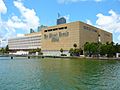
The Miami Herald operated from this headquarters on Biscayne Bay in Downtown Miami from March 1963 until May 2013, when the building was sold to a Malaysian company for $236 million and demolished. The Miami Herald is now headquartered in Doral, about 13 miles from Downtown Miami


See also
 In Spanish: Área metropolitana del Sur de la Florida para niños
