
Micronesia facts for kids


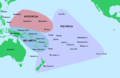
Micronesia is a subregion of Oceania, composed of thousands of small islands in the western Pacific Ocean. It has a shared cultural history with two other island regions, Polynesia to the east and Melanesia to the south.
The region has a tropical marine climate, and is part of the Oceania ecozone. There are four main archipelagos along with numerous outlying islands.
Micronesia is divided politically among several sovereign countries. One of these is the Federated States of Micronesia, which is often called "Micronesia" for short and is not to be confused with the overall region. The Micronesia region encompasses five sovereign, independent nations—the Federated States of Micronesia, Palau, Kiribati, Marshall Islands, and Nauru—as well as three U.S. territories in the northern part: Northern Mariana Islands, Guam, and Wake Island.
Micronesia began to be settled several millennia ago, although there are competing theories about the origin and arrival of the first settlers. The earliest known contact with Europeans occurred in 1521, when Ferdinand Magellan reached the Marianas. The coinage of the term "Micronesia" is usually attributed to Jules Dumont d'Urville's usage in 1832; however, Domeny de Rienzi had used the term a year previously.
Contents
Geography

Micronesia is a region that includes approximately 2100 islands, with a total land area of 2,700 km2 (1,000 sq mi), the largest of which is Guam, which covers 582 km2 (225 sq mi). The total ocean area within the perimeter of the islands is 7,400,000 km2 (2,900,000 sq mi).
There are four main island groups in Micronesia:
- the Caroline Islands (Federated States of Micronesia and Palau)
- the Gilbert Islands (Republic of Kiribati)
- the Mariana Islands (Northern Mariana Islands and Guam)
- the Marshall Islands
Plus the island country of Nauru.
Caroline Islands
The Caroline Islands are a widely scattered archipelago consisting of about 500 small coral islands, north of New Guinea and east of the Philippines. The Carolines consist of two states: the Federated States of Micronesia, consisting of approximately 600 islands on the eastern side of the chain with Kosrae being the most eastern, and Palau consisting of 250 islands on the western side.
Gilbert Islands
The Gilbert Islands are a chain of sixteen atolls and coral islands, arranged in an approximate north-to-south line. In a geographical sense, the equator serves as the dividing line between the northern Gilbert Islands and the southern Gilbert Islands. The Republic of Kiribati contains all of the Gilberts, as well as the island of Tarawa, the site of the country's capital.
Mariana Islands
The Mariana Islands are an arc-shaped archipelago made up by the summits of fifteen volcanic mountains. The island chain arises as a result of the western edge of the Pacific Plate moving westward and plunging downward below the Mariana plate, a region which is the most volcanically active convergent plate boundary on Earth. The Marianas were politically divided in 1898, when the United States acquired title to Guam under the Treaty of Paris, 1898, which ended the Spanish–American War. Spain then sold the remaining northerly islands to Germany in 1899. Germany lost all of her colonies at the end of World War I and the Northern Mariana Islands became a League of Nations Mandate, with Japan as the mandatory. After World War II, the islands were transferred into the United Nations Trust Territory System, with the United States as Trustee. In 1976, the Northern Mariana Islands and the United States entered into a covenant of political union under which commonwealth status was granted the Northern Mariana Islands, and its residents received United States citizenship.
Marshall Islands
.jpg)
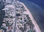
The Marshall Islands are located north of Nauru and Kiribati, east of the Federated States of Micronesia, and south of the U.S. territory of Wake Island. The islands consist of 29 low-lying atolls and 5 isolated islands, comprising 1,156 individual islands and islets. The atolls and islands form two groups: the Ratak Chain and the Ralik Chain (meaning "sunrise" and "sunset" chains). All the islands in the chain are part of the Republic of the Marshall Islands, a presidential republic in free association with the United States. Having few natural resources, the islands' wealth is based on a service economy, as well as some fishing and agriculture. Of the 29 atolls, 24 of them are inhabited.
Bikini Atoll is an atoll in the Marshall Islands. There are 23 islands in the Bikini Atoll. The islands of Bokonijien, Aerokojlol, and Nam were vaporized during nuclear tests that occurred there. The islands are composed of low coral limestone and sand. The average elevation is only about 2.1 metres (7 ft) above low tide level.
-
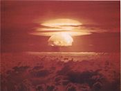
Image of the Castle Bravo nuclear test, detonated on March 1, 1954, at Bikini Atoll
-
An illustration of the Cross Spikes Club of the US Navy on Bikini Atoll, one of several Marshall Islands used for atomic bomb tests.
-
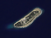
Kili Island is one of the smallest islands in the Marshall Islands.


Nauru
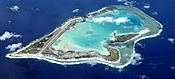
Nauru is an oval-shaped island country in the southwestern Pacific Ocean, 42 km (26 mi) south of the Equator, listed as the world's smallest republic, covering just 21 km2 (8 sq mi). With 10,670 residents, it is the second least-populated country, after Vatican City. The island is surrounded by a coral reef, which is exposed at low tide and dotted with pinnacles. The presence of the reef has prevented the establishment of a seaport, although channels in the reef allow small boats access to the island. A fertile coastal strip 150 to 300 m (490 to 980 ft) wide lies inland from the beach.
-
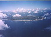
Aerial view of Nauru
-
Nauruan districts of Denigomodu and Nibok


Wake Island
Wake Island is a coral atoll with a coastline of 19 km (12 mi) just north of the Marshall Islands. It is an unorganized, unincorporated territory of the United States. Access to the island is restricted, and all activities on the island are managed by the United States Air Force.
-
Wake Island as depicted by the United States Exploring Expedition, drawn by Alfred Thomas Agate
-
Aerial view Wake Island, looking westward


Geology
The majority of the islands in the area are part of a coral atoll. Coral atolls begin as coral reefs that grow on the slopes of a central volcano. When the volcano sinks back down into the sea, the coral continues to grow, keeping the reef at or above water level. One exception is Pohnpei in the Federated States of Micronesia, which still has the central volcano and coral reefs around it.
Climate
The region has a tropical marine climate moderated by seasonal northeast trade winds. There is little seasonal temperature variation. The dry season runs from December or January to June, and the rainy season from July to November or December. Because of the location of some islands, the rainy season can sometimes include typhoons.
List of islands and countries in Micronesia
- Gilbert Islands (in Republic of Kiribati)
- Republic of the Marshall Islands
- Federated States of Micronesia (It may be called just Micronesia)
- Republic of Nauru
- Republic of Palau
- Mariana Islands
- Territory of Wake Island.
Images for kids
-
Micronesia is one of three major cultural areas in the Pacific Ocean, along with Polynesia and Melanesia
-
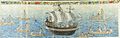
Manila Galleon in the Marianas and Carolinas, c. 1590 Boxer Codex
-
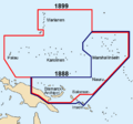
German New Guinea before and after the German-Spanish treaty of 1899
-
Map from 1961 of the US Trust Territory of the Pacific Islands, formerly Japan's South Seas Mandate.
-
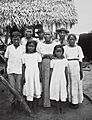
Chamorro people in 1915
-
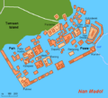
Central Nan Madol (map)
-
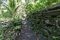
Leluh
-
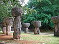
Latte stones
-
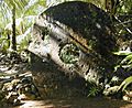
Rai stone


See also
 In Spanish: Micronesia para niños
