
Mid-Atlantic States facts for kids

The Mid-Atlantic States (also called Middle Atlantic States or simply Middle East) form one of the nine geographic divisions within the United States that are officially recognized by the United States Census Bureau. The division consists of three states: New Jersey, New York, and Pennsylvania.
This definition corresponds with the region's traditional definition as the section of the Atlantic Seaboard between New England and the South. However, many people consider the Mid-Atlantic to be the states south of the Northeast, centered in Delaware, Maryland.
The traditional Mid-Atlantic States comprise the most densely-populated of the nine U.S. regions, and anchor the megalopolis which runs from Boston to Washington, D.C.. The southeastern part of New York State, eastern Pennsylvania, and all of New Jersey combine to form the bulk of the moral region of the Metropolis, according to socio-political geographers James Patterson and Peter Kim, co-authors of the 1991 book The Day America Told The Truth. (Metropolis begins in the southern Connecticut suburbs of New York City and stretches along the Eastern seaboard to the northern Virginia suburbs of Washington, D.C.). The book classifies the remainder of New York State and Pennsylvania in the Rust Belt.
Images for kids
-

Shipping containers at the Port Newark–Elizabeth Marine Terminal, part of the Port of New York and New Jersey.
-
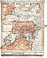
An 1897 map displays an inclusive definition of the Mid-Atlantic region.
-
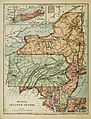
An 1886 "Harper's School Geography" map showing the region, exclusive of Virginia and West Virginia.


See also
 In Spanish: Atlántico Medio de Estados Unidos para niños
