
Midtown, Wichita, Kansas facts for kids
Quick facts for kids
Midtown
|
|
|---|---|
| Country | United States |
| State | Kansas |
| County | Sedgwick |
| City | Wichita |
| Population
(2016)
|
|
| • Total | 11,147 |
| ZIP code |
67202, 67203, 67214
|
| Area code | 316 |
Midtown is a neighborhood in Wichita, Kansas, United States. A mixed commercial and residential area on the east bank of the Little Arkansas River, it is the oldest neighborhood in the city.
Contents
History
Present-day Midtown was the original town site of Wichita, first platted in 1865 and initially settled in the late 1860s and 1870s. Postmaster, surveyor, and hotelkeeper Darius Munger built the city’s first house in 1868 at the corner of what are today Waco and 9th Streets. Constructed from cottonwood logs, his house went on to serve as a hotel, justice hall, community center, and post office. By 1869, Munger had built and owned several more buildings. In 1870, he and Bill “Dutch Bill” Griffenstein filed plats laying out the first portions of the city’s street grid, including what would become Main Street and Broadway. Griffenstein attracted businesses by offering free lots on Main Street. Also during this period, the city’s first jail, the Wyatt Earp Jail, and first school both opened in what is today Midtown.
The city subsequently grew northward with settlers initially building Victorian homes on large estates. Property taxes increased with the demand for city services, and residents responded by subdividing and selling off their lots, increasing building density. Further development of Midtown continued through the 1940s when workers from Wichita’s burgeoning aviation industry moved into the neighborhood. By the 1960s, however, Midtown had entered a period of decline.
Beginning in 1972, local residents organized to preserve the neighborhood and worked with the city government to have multiple areas declared to be historic districts.
Geography
Midtown consists of the area between 21st Street to the north, Central Avenue to the south, the Little Arkansas River to the west, and the BNSF/Union Pacific rail corridor to the east. It overlaps with a portion of the Riverside neighborhood to the west. Located immediately north of Downtown Wichita, it lies south of El Pueblo, west of McAdams, and east of North Riverside.
Parks and recreation
- Prospect Park
- Woodland Park
Culture
Points of interest
- Kansas African American Museum
Education
Primary and secondary education
Wichita Public Schools operates five facilities in Midtown:
- Gateway Alternate Program Center
- Horace Mann Dual Language Magnet
- Irving Elementary School
- Park Elementary School
- Wichita North High School
The Roman Catholic Diocese of Wichita oversees one Catholic elementary school in the neighborhood, St. Patrick School.
Transportation
Broadway is the main north-south street through Midtown. 13th Street and Murdock Street are primary east-west streets. Other arterial roads include: Waco Avenue, which runs north-south several blocks west of Broadway; 21st Street, which runs east-west along the northern edge of the neighborhood; and Central Avenue, which runs east-west along the southern edge of the neighborhood.
Wichita Transit offers bus service in Midtown on its 13, 17, 25, and 27 routes.
BNSF Railway and Union Pacific Railroad operate freight rail lines which run north-south immediately east of Midtown, parallel to Santa Fe Avenue.
Images for kids
-
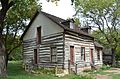
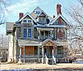
The Darius Munger House (2012)
-

Kansas African American Museum (2018)
-
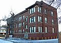
Adeline Apartments (2013)
-

Bond-Sullivan House (2013)
-

Bowers House (2013)
-

Chapman-Noble House (2013)
-

Comley House (2013)
-

Commodore Apartments (2013)
-

Edward M. Kelly House (2013)
-

First Presbyterian Church (2018)
-
Gelbach House (2013)
-

Hypatia House (2013)
-

Market Street Cottage (2013)
-
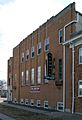
Murdock Theatre (2018)
-

Riverview Apartments (2013)
-
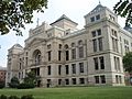
Old Sedgwick County Courthouse (2009)
-
William Sternberg House (2013)


