
Milbrulong facts for kids
Quick facts for kids MilbrulongNew South Wales |
|
|---|---|

Entering Milbrulong
|
|

Milbrulong
Location in New South Wales
|
|
| Population | 366 (2006 census) |
| Postcode(s) | 2656 |
| Elevation | 123 m (404 ft) |
| Location |
|
| LGA(s) | Lockhart Shire |
| County | Urana |
| State electorate(s) | Wagga Wagga |
| Federal Division(s) | Riverina |
Milbrulong is a locality in the central east part of the Riverina region of New South Wales, Australia.
The locality is 515 kilometres (320 mi) south west of the state capital, Sydney and 59 kilometres (37 mi) south west of the regional centre Wagga Wagga in the Lockhart Shire local government area. The standard gauge Oaklands railway line passes through the locality.
At the 2006 census, Milbrulong had a population of 366.
Gallery
-
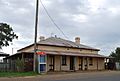
The former Boundary Inn Hotel
-
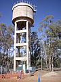
Milbrulong water tank
-
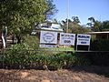
Milbrulong Public School
-
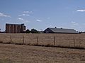
Silos at Milbrulong


| Preceding station | NSW Branch lines | Following station | ||
|---|---|---|---|---|
|
Template:NSW Country lines stations
toward Template:NSW Country lines stations
|
Template:NSW Country lines lines |
Template:NSW Country lines stations
toward Template:NSW Country lines stations
|

All content from Kiddle encyclopedia articles (including the article images and facts) can be freely used under Attribution-ShareAlike license, unless stated otherwise. Cite this article:
Milbrulong Facts for Kids. Kiddle Encyclopedia.