Milford, New Jersey facts for kids
Quick facts for kids
Milford, New Jersey
|
|
|---|---|
|
Borough
|
|
| Borough of Milford | |

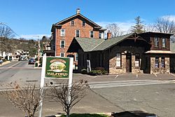
Bridge Street, by Railroad Avenue
|
|

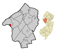
Map of Milford in Hunterdon County. Inset: Location of Hunterdon County in the State of New Jersey.
|
|

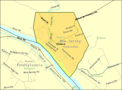
Census Bureau map of Milford, New Jersey
|
|
| Country | |
| State | |
| County | |
| Incorporated | May 8, 1911 |
| Government | |
| • Type | Borough |
| • Body | Borough Council |
| Area | |
| • Total | 1.27 sq mi (3.29 km2) |
| • Land | 1.18 sq mi (3.06 km2) |
| • Water | 0.09 sq mi (0.23 km2) 6.93% |
| Area rank | 476th of 565 in state 19th of 26 in county |
| Elevation | 253 ft (77 m) |
| Population | |
| • Total | 1,233 |
| • Estimate
(2019)
|
1,181 |
| • Rank | 525th of 566 in state 23rd of 26 in county |
| • Density | 1,073.4/sq mi (414.4/km2) |
| • Density rank | 372nd of 566 in state 9th of 26 in county |
| Time zone | UTC−05:00 (Eastern (EST)) |
| • Summer (DST) | UTC−04:00 (Eastern (EDT)) |
| ZIP Code |
08848
|
| Area code(s) | 908 Exchange: 995 |
| FIPS code | 3401946260 |
| GNIS feature ID | 885301 |
Milford is a borough located in western Hunterdon County, New Jersey, United States. At the 2010 United States Census, the borough's population was 1,233, reflecting an increase of 38 (+3.2%) from the 1,195 counted in the 2000 Census, which had in turn declined by 78 (-6.1%) from the 1,273 counted in the 1990 Census.
Milford was incorporated as a borough by an act of the New Jersey Legislature on April 15, 1911, from portions of Holland Township, based on the results of a referendum held on May 8, 1911. The borough's incorporation was confirmed on March 13, 1925.
The borough is located on the Delaware River in the western portion of Hunterdon County, known as the Hunterdon Plateau. The Borough dates to the mid-18th century when a grist mill was established beside a river in what was then Bethlehem Township. After the mill was destroyed by fire in 1769, the settlement became known as Burnt Mills in Alexandria Township. The area was renamed as "Lowreytown" after Thomas Lowrey purchased land in the area in 1796. The community became commonly known as "Millford" or "Millsford" by the beginning of the 19th century, but by 1844 the name had lost a letter or two. By 1863 it was consistently spelled as "Milford". The community was incorporated in 1911 but the official incorporation was not registered until 1925.
Contents
Geography
According to the United States Census Bureau, the borough had a total area of 1.226 square miles (3.175 km2), including 1.149 square miles (2.975 km2) of land and 0.077 square miles (0.200 km2) of water (6.31%).
Milford borders Alexandria Township and Holland Township. Milford also borders the Commonwealth of Pennsylvania and is connected to Upper Black Eddy, Bridgeton Township, Bucks County, Pennsylvania by the Delaware River Joint Toll Bridge Commission's free Upper Black Eddy-Milford Bridge over the Delaware River.
Demographics
| Historical population | |||
|---|---|---|---|
| Census | Pop. | %± | |
| 1920 | 656 | — | |
| 1930 | 933 | 42.2% | |
| 1940 | 933 | 0.0% | |
| 1950 | 1,012 | 8.5% | |
| 1960 | 1,114 | 10.1% | |
| 1970 | 1,230 | 10.4% | |
| 1980 | 1,368 | 11.2% | |
| 1990 | 1,273 | −6.9% | |
| 2000 | 1,195 | −6.1% | |
| 2010 | 1,233 | 3.2% | |
| 2019 (est.) | 1,181 | −4.2% | |
| Population sources:1920 1920-1930 1930-1990 2000 2010 |
|||
Census 2010
As of the census of 2010, there were 1,233 people, 520 households, and 331 families residing in the borough. The population density was 1,073.4 per square mile (414.4/km2). There were 552 housing units at an average density of 480.5 per square mile (185.5/km2)*. The racial makeup of the borough was 97.32% (1,200) White, 0.24% (3) Black or African American, 0.16% (2) Native American, 0.97% (12) Asian, 0.08% (1) Pacific Islander, 0.24% (3) from other races, and 0.97% (12) from two or more races. [[Hispanic (U.S. Census)|Hispanic or Latino of any race were 2.19% (27) of the population.
There were 520 households out of which 26.7% had children under the age of 18 living with them, 51.7% were married couples living together, 7.9% had a female householder with no husband present, and 36.3% were non-families. 28.8% of all households were made up of individuals, and 12.3% had someone living alone who was 65 years of age or older. The average household size was 2.36 and the average family size was 2.93.
In the borough, the population was spread out with 20.6% under the age of 18, 6.4% from 18 to 24, 24.2% from 25 to 44, 32.8% from 45 to 64, and 16.0% who were 65 years of age or older. The median age was 44.1 years. For every 100 females there were 95.7 males. For every 100 females ages 18 and old there were 97.0 males.
The Census Bureau's 2006-2010 American Community Survey showed that (in 2010 inflation-adjusted dollars) median household income was $75,948 (with a margin of error of +/- $6,902) and the median family income was $79,653 (+/- $5,673). Males had a median income of $52,679 (+/- $12,062) versus $42,778 (+/- $8,377) for females. The per capita income for the borough was $32,823 (+/- $2,774). About 0.9% of families and 2.6% of the population were below the poverty line, including none of those under age 18 and 6.6% of those age 65 or over.
Census 2000
At the 2000 United States Census there were 1,195 people, 469 households and 323 families residing in the borough. The population density was 1,037.7 per square mile (401.2/km2). There were 484 housing units at an average density of 420.3 per square mile (162.5/km2). The racial makeup of the borough was 97.57% White, 0.17% African American, 0.17% Native American, 0.42% Asian, 0.33% Pacific Islander, 0.08% from other races, and 1.26% from two or more races. Hispanic or Latino of any race were 2.01% of the population.
There were 469 households, of which 33.5% had children under the age of 18 living with them, 59.1% were married couples living together, 5.5% had a female householder with no husband present, and 31.1% were non-families. 27.1% of all households were made up of individuals, and 11.9% had someone living alone who was 65 years of age or older. The average household size was 2.55 and the average family size was 3.11.
25.4% of the population were under the age of 18, 4.6% from 18 to 24, 33.3% from 25 to 44, 23.1% from 45 to 64, and 13.6% who were 65 years of age or older. The median age was 39 years. For every 100 females, there were 102.9 males. For every 100 females age 18 and over, there were 97.3 males.
The median household income was $54,519 and the median family income was $62,167. Males had a median income of $46,500 and females $31,765. The per capita income was $25,039. About 1.8% of families and 3.7% of the population were below the poverty line, including 3.7% of those under age 18 and 6.4% of those age 65 or over.
Transportation
Roads and highways
In May 2010, the borough had 10.34 mi (16.64 km) of roadways, of which 7.86 mi (12.65 km) were maintained by the municipality and 2.48 mi (3.99 km) by Hunterdon County.
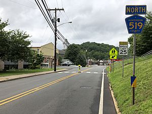
County Route 519 is the only major roadway passing through Milford.
The Upper Black Eddy – Milford Bridge, owned and operated by the Delaware River Joint Toll Bridge Commission, carries Bridge Street across the Delaware River, connecting CR 519 in Milford with Pennsylvania Route 32 in Upper Black Eddy, Pennsylvania. The existing bridge was constructed in 1933 on the site of a covered bridge built in 1842 and another partially destroyed in a 1903 flood. The bridge is a Warren truss that extends 700 ft (210 m) across the river.
Public transportation
The Hunterdon County LINK provide bus service on Routes 17 / 18, which operate between Milford and Clinton.
Education
The Milford Borough School District serves public school students in pre-kindergarten through eighth grade at Milford Public School. As of the 2018–19 school year, the district, comprised of one school, had an enrollment of 88 students and 11.4 classroom teachers (on an FTE basis), for a student–teacher ratio of 7.7:1. In the 2016–17 school year, Milford was the 5th-smallest enrollment of any school district in the state, with 81 students.
Students in public school for ninth through twelfth grades attend Delaware Valley Regional High School, together with students from Alexandria Township, Frenchtown, Holland Township and Kingwood Township. As of the 2018–19 school year, the high school had an enrollment of 721 students and 68.4 classroom teachers (on an FTE basis), for a student–teacher ratio of 10.5:1. The nine seats on the high school district's board of education are allocated based on the population of the constituent municipalities, with one seat assigned to Milford.
Eighth grade students from all of Hunterdon County are eligible to apply to attend the high school programs offered by the Hunterdon County Vocational School District, a county-wide vocational school district that offers career and technical education at its campuses in Raritan Township and at programs sited at local high schools, with no tuition charged to students for attendance.
Notable people
People who were born in, residents of, or otherwise closely associated with Milford include:
- Louis Adamic (1899-1951), Slovene-American author and translator.
- Carlton Cooley (1898-1981), violist and composer.
- Elias Deemer (1838-1918) member of the United States House of Representatives from Pennsylvania from 1901 to 1907.
- Richard Egielski (born 1952), illustrator who was awarded the 1987 Caldecott Medal for his work in the book Hey, Al, written by Arthur Yorinks.
- Wanda Gág (1893-1946), artist and author of children's books (Millions of Cats).
- Thomas Lowrey (1737-1809), settled in Milford in the 1790s and built the first hotel and grist mill on Bridge Street. He named the town Lowreytown, but it was renamed Millsford following his death in 1809.
- George C. Ludlow (1830-1900), 25th Governor of New Jersey.
- Abigail Roberts (1791-1841), pioneer in religion and women's rights who was one of the first American women to serve as a minister and established the United Church in Milford.
See also
 In Spanish: Milford (Nueva Jersey) para niños


