
Millard County, Utah facts for kids
Quick facts for kids
Millard County
|
|
|---|---|

Old Millard County courthouse
|
|

Location within the U.S. state of Utah
|
|
 Utah's location within the U.S. |
|
| Country | |
| State | |
| Founded | October 4, 1851 |
| Named for | Millard Fillmore |
| Seat | Fillmore |
| Largest city | Delta |
| Area | |
| • Total | 6,828 sq mi (17,680 km2) |
| • Land | 6,572 sq mi (17,020 km2) |
| • Water | 255 sq mi (660 km2) 3.7% |
| Population
(2020)
|
|
| • Total | 12,975 |
| • Density | 1.90026/sq mi (0.73370/km2) |
| Time zone | UTC−7 (Mountain) |
| • Summer (DST) | UTC−6 (MDT) |
| Congressional district | 2nd |
Millard County ( MIL-ərd) is a county in the U.S. state of Utah. As of the 2020 United States Census, the population was 12,975. Its county seat is Fillmore, and the largest city is Delta.
Contents
History
The Utah Territory legislature created the county on October 4, 1851, with territory not previously covered by county creations and including some area in the future state of Nevada. It was named for the thirteenth US President Millard Fillmore, who was in office then. Fillmore was designated as the county seat. The county boundaries were altered in 1852 and again in 1854. On March 2, 1861, the US government created the Nevada Territory, which effectively de-annexed the described portion of Millard County falling in that Territorial Proclamation. The county boundary was further altered in 1862, 1866, 1888, and in 1919. In 1921 a boundary adjustment with Sevier brought Millard to its present configuration.
Fillmore, located near the geographic center of the territory, was originally built as the capital of Utah Territory. The Utah Territorial Legislature approved a plan to locate the capital in the Pahvant Valley. On October 28, 1851, Utah Governor Brigham Young traveled to the valley and chose the specific site for Fillmore. The town was surveyed that same day. A colonizing company soon followed; they built houses, a grist mill, and a sawmill. Construction of the Territorial Statehouse was initiated in 1852. The Territorial legislature met in Fillmore for the first (and only time) in 1855. The following year they voted to keep the capital in Great Salt Lake City.
Geography
Millard County lies on the west side of Utah. Its west border abuts the east border of the state of Nevada. The county terrain consists of arid, rough undulating flatlands interrupted by numerous hills and mountain ridges. The highest point in the county is Mine Camp Peak in the Central Utah Plateaus, at 10,222 feet (3,116 m) ASL. The county has a total area of 6,828 square miles (17,680 km2), of which 6,572 square miles (17,020 km2) is land and 255 square miles (660 km2) (3.7%) is water. It is the third-largest county in Utah by area.
The Sevier Desert covers much of Millard County, being the seafloor of ancient Lake Bonneville. Sevier Lake, a mostly dry remnant of Lake Bonneville, is in central Millard County. The Pahvant Mountains form the county's eastern boundary. Fillmore and other farming communities lie at the base of the Pahvant Mountains. Delta sits several miles from the banks of the Sevier River in the middle of the basin.
Major highways
- Interstate 15
- Interstate 70
- US 6
- US 50
- Utah State U-21
- Utah State U-100
- Utah State U-125
- Utah State U-132
- Utah State U-133
- Utah State U-136
- Utah State U-257
Adjacent counties
- Juab County - north
- Sanpete County - northeast
- Sevier County - southeast
- Beaver County - south
- Lincoln County, Nevada - southwest
- White Pine County, Nevada - west
Protected areas
- Circus Hollow Wildlife Management Area
- Clear Lake Waterfowl Management Area
- Fishlake National Forest (part)
- Halfway Hill Wildlife Management Area
Lakes
- Abraham Reservoir
- Alexander Lake
- Antelope Spring (along Cove Creek)
- Antelope Spring Reservoir
- AT T Road Reservoir
- Beaver River Reservoir
- Big Drum Reservoir
- Big Sage Reservoir
- Bitterweed Lake
- Black Point Reservoir
- Black Spring
- Bloom Trail Reservoir
- Borden Basin Reservoir
- Burnt Tree Pond
- Carr Lake
- Cat Canyon Reservoir
- Cedar Pass Reservoir
- Chokecherry Reservoir
- Clay Knoll Reservoir
- Clear Lake
- Clear Spot Reservoirs
- Coates Reservoir
- Cockleburr Lake
- Confusion Hills Reservoir
- Conger Reservoir
- Construction Reservoir
- Coyote Spring (near Beaver River)
- Coyote Spring (Tule Valley)
- Crafts Lake
- Crater Reservoir
- Cricket Reservoir
- Cricket Reservoir Number 2
- D M A D Reservoir
- Danish Reservoir
- Deadman Reservoir
- Deep Lake
- Deseret Reservoirs
- Devils Kitchen Reservoir
- East Antelope Reservoir
- East Hardpan Reservoir
- East Tule Bench Reservoir
- Ecks Knoll Reservoir
- Fillmore Wash Reservoir
- Fool Creek Number Two Reservoir
- Fool Creek Reservoir Number 1
- Foote Reservoir
- Georges Reservoir
- Greener Reservoir
- Gunnison Bend Reservoir
- Halls Double Reservoir
- Hardpan Reservoir
- Headquarters Reservoir
- Highway Reservoir
- Hinckley Trail Reservoir
- Hodgsen Pond
- Hole-in-the-Rock Reservoir
- Horsetrap Reservoir
- Indian Queen Reservoir
- Indian Ranch
- Jackson Pond
- Jensen Spring
- Johnson Pond
- Lakeview Reservoir
- Lawson Cove Reservoir
- Little Drum Reservoir
- Long Ridge Reservoir
- Lower Clay Spring
- Madsen Reservoir
- Miller Canyon Reservoir
- Mormon Gap Reservoir
- Mud Flat Reservoir
- Mud Lake Spring
- Mud Springs
- Needle Hardpan Reservoir
- Needle Reservoir
- Neels Reservoir Number 2
- Nelson Reservoir Number 2
- Nielson Pond
- North Clay Knoll Reservoir
- North Knoll Spring
- Pine Pass Reservoir
- Pony Express Reservoir
- Preuss Lake
- Probst Pond
- Rain Lakes
- Red Rock Number 1 Reservoir
- Red Rock Number 2 Reservoir
- Robins Lake
- Ruths Pond
- Salt Lake
- Salt Marsh Lake
- Scipio Lake
- Sevier Lake
- Sevier Lake Reservoir
- Sevier Lake Reservoir Number 1
- Sevier Lake Reservoir Number 4
- Sevier Lake Reservoir Number 5
- Sevier Lake Reservoir Number 6
- Smelter Knolls Reservoir
- Snake Pass Reservoir
- Soap Hollow Reservoir
- Soap Wash Reservoir
- South Cedar Wash Reservoir
- South Horse Hollow Reservoir
- South Tule Spring
- Spring Lake
- Squidike Spring
- Stage Road Reservoir
- Steamboat Pass Reservoir
- Styler Reservoir
- Swan Lake
- Swan Lake Salt Marsh
- Swasey Hardpan Reservoir
- Swasey Reservoir Number 2
- Swasey Reservoir Number 3
- Swasey Reservoir Number 4
- Swasey Wash Reservoir
- Tamarack Reservoir
- The Lakes
- Thompson Knoll Reservoir
- Topaz Slough
- Tule Spring
- Twin Springs
- Warm Springs
- Watsons Cow Pond
- West Clay Knoll Reservoir
- West Marshall Tract Reservoir
- West Neels Reservoir
- Whirlwind Reservoir
- Willow Spring (near Tule Spring)
Great Stone Face

Pahvant Valley in Millard County has several ancient lava flows and extinct volcanoes, known as the Black Rock Desert volcanic field, including the "Black Rock" lava flow. About 17 miles (27 km) southwest of Delta, near Black Rock's northwest perimeter is a feature named the "Great Stone Face", which protrudes about four stories above the general elevation. Locals claim that this rock formation, when viewed at the correct angle, appears similar to a profile of Joseph Smith. At ground level, within view of the "Great Stone Face", is a large, smooth-faced rock covered in Native American petroglyphs.
Notch Peak
Notch Peak is 50 miles (80 km) west of Delta. The skyline appears to have a notch taken out of it when viewed from Delta.
Little Sahara Sand Dunes
Little Sahara Recreation Area, 25 miles (40 km) north of Delta, is a popular area for ATV riders.
Demographics
| Historical population | |||
|---|---|---|---|
| Census | Pop. | %± | |
| 1860 | 715 | — | |
| 1870 | 2,753 | 285.0% | |
| 1880 | 3,727 | 35.4% | |
| 1890 | 4,033 | 8.2% | |
| 1900 | 5,678 | 40.8% | |
| 1910 | 6,118 | 7.7% | |
| 1920 | 9,659 | 57.9% | |
| 1930 | 9,945 | 3.0% | |
| 1940 | 9,613 | −3.3% | |
| 1950 | 9,387 | −2.4% | |
| 1960 | 7,866 | −16.2% | |
| 1970 | 6,988 | −11.2% | |
| 1980 | 8,970 | 28.4% | |
| 1990 | 11,333 | 26.3% | |
| 2000 | 12,405 | 9.5% | |
| 2010 | 12,503 | 0.8% | |
| 2020 | 12,975 | 3.8% | |
| US Decennial Census 1790–1960 1900–1990 1990–2000 2010 2020 |
|||
As of the 2000 United States Census, there were 12,405 people, 3,840 households, and 3,091 families in the county. The population density was 1.89 people per square mile (0.73 people/km2). There were 4,522 housing units at an average density of 0.69 units per square mile (0.27 units/km2). In 2000 there were 3,840 households, of which 46.10% had children under 18 living with them, 70.60% were married couples living together, 7.10% had a female householder with no husband present, and 19.50% were non-families. 18.30% of all households were made up of individuals, and 10.10% had someone living alone who was 65 years of age or older. The average household size was 3.19, and the average family size was 3.66.
The county population contained 37.30% under 18, 8.00% from 18 to 24, 22.90% from 25 to 44, 19.40% from 45 to 64, and 12.30% who were 65 years of age or older. The median age was 30 years. For every 100 females, there were 104.90 males. For every 100 females aged 18 and over, there were 101.90 males.
The median income for a household in the county was $36,178, and the median income for a family was $41,797. Males had a median income of $36,989 versus $20,168 for females. The per capita income for the county was $13,408. About 9.40% of families and 13.10% of the population were below the poverty line, including 17.20% of those under age 18 and 7.20% of those aged 65 or over.
The 2000 Census reported the racial makeup of the county was 93.94% White, 0.10% Black or African American, 1.31% Native American, 0.48% Asian, 0.20% Pacific Islander, 2.76% from other races, and 1.21% from two or more races. 7.18% of the population were Hispanic or Latino of any race.
By 2005, 86.7% of Millard County's population was non-Hispanic whites. The proportion of African Americans had doubled to 0.2%. Native Americans were now 1.5% of the country's population. Asians had fallen to only 0.4% of the population. 11.0% of the population was Latino, just above the 10.9% for Utah.
As of 2010, Millard County had a population of 12,310. The ethnic and racial makeup of the population was 84.7% non-Hispanic white, 0.1% black, 1.0% Native American, 0.6% Asian, 0.1% Pacific Islander, 1.5% reporting two or more races, and 12.8% Hispanic or Latino.
Economy
Millard County is working hard to make it easier to build Earthships, straw bale homes, and other ecological and sustainable housing.
Millard County is the home of the Telescope Array Project ultra-high-energy cosmic ray observatory. The Lon and Mary Watson Millard County Cosmic Ray Center was dedicated on March 20, 2006.
Japanese internment camp
The Topaz War Relocation Center was a World War II Japanese internment camp located in Millard County 15 miles (24 km) west of Delta. The location is open to the public, with a memorial at the northwest corner.
Communities

Cities
Towns
Census-designated places
Unincorporated communities
Former communities
- Bloom
- Borden
- Clear Lake
- Greenwood
- Ibex
- Sunflower
- Topaz
- Van
Gallery
-
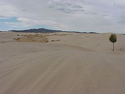
Little Sahara Sand Dunes
-
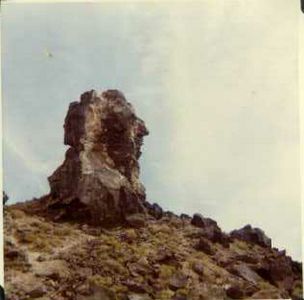
The Great Stone Face
-
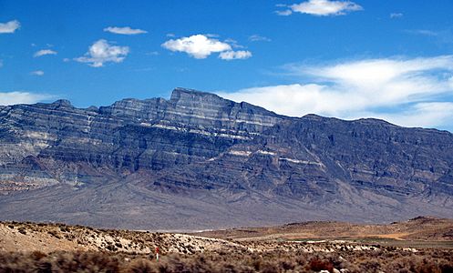
Notch Peak as seen from the south on the valley floor
-
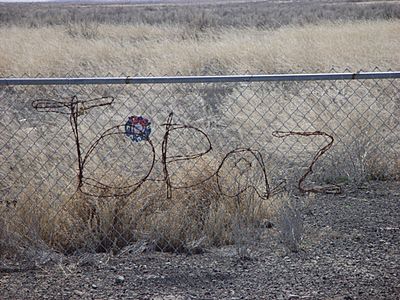
Topaz Internment Camp


See also
 In Spanish: Condado de Millard para niños
- Cove Fort, Utah
- National Register of Historic Places listings in Millard County, Utah
- USS Millard County (LST-987)
- Willden Fort
