
Millbourne, Pennsylvania facts for kids
Quick facts for kids
Millbourne, Pennsylvania
|
|
|---|---|
| Borough of Millbourne | |

Millbourne's Market-Frankford Line station
|
|

Location in Delaware County and the U.S. state of Pennsylvania
|
|

Millbourne, Pennsylvania
Location in Pennsylvania

Millbourne, Pennsylvania
Location in the United States
|
|
| Country | |
| State | |
| County | Delaware |
| Founded | 1909 |
| Founded by | Samuel Shoemaker and John L. Fry |
| Named for | Millbourne Mills |
| Government | |
| • Type | Mayor–council government |
| Area | |
| • Total | 0.07 sq mi (0.19 km2) |
| • Land | 0.07 sq mi (0.19 km2) |
| Elevation | 128 ft (39 m) |
| Population
(2020)
|
|
| • Total | 1,212 |
| • Density | 1,731.43/sq mi (6,378.95/km2) |
| Time zone | UTC-5 (EST) |
| • Summer (DST) | UTC-4 (EDT) |
| Area codes | 610 and 484 |
| FIPS code | 42-49504 |
Millbourne is a borough in Delaware County, Pennsylvania, United States. As of the 2020 Census, the population is 1,212. Millbourne borders Philadelphia along Cobbs Creek. The borough was the former site of the Sellers Family's Millbourne Mills. The name of Millbourne Mills comes from the word Mill and "bourne" meaning creek. Millbourne students attend Upper Darby School District schools. Magisterial courts with presiding jurisdiction for Millbourne are also located in Upper Darby. Millbourne, at over 17,000 people per square mile, is the most densely populated incorporated place in Pennsylvania, and 22nd in the entire United States.
Contents
Geography
Millbourne Borough is located at 39°57′48″N 75°15′14″W / 39.96333°N 75.25389°W (39.963412, -75.253998).
According to the United States Census Bureau, the borough has a total area of 0.1 square miles (0.2 km2), all land, making it the smallest municipality in Delaware County, Pennsylvania by area.
The borough is small enough that it is entirely within walking distance of its elevated station on the Market-Frankford Line. The Millbourne station, newly rebuilt and rededicated in mid-2008, offers an 11-minute commute to University of Pennsylvania and Drexel University and a 15-minute commute to Center City. Millbourne is also within easy walking distance of the 69th Street Terminal in Upper Darby and the 63rd Street Station in West Philadelphia, both of which are on the Market-Frankford Line. The Philadelphia Inquirer reported in the early 21st century that, according to U.S. Census data, only about one-third of Millbourne workers commuted by car. There is a PhillyCarShare shared car "node" at 69th Street Station, easily accessible from Millbourne or by commuters exiting the Market Frankford El at 69th Street.
The Borough is approximately bounded on the north and east by Cobbs Creek, and on the south by Market Street. The creek is graced by an historic mill dam and a bridge said to be eligible for placement on national historic registries. Across Cobbs Creek to the north lies an extension of Fairmount Park and the Cobbs Creek Golf Course. Against all odds, snowy egrets have been seen in this very urban creek environment. In the 1990s what was apparently a pet cougar got loose in the park. Despite police efforts to catch it (and the neighborhood's efforts to keep it well fed with Big Macs) the cougar was last seen loping west on the median strip of West Chester Pike—free.
Cobbs Creek originally hosted the Millbourne Mills, a flour mill, and slightly further south in Upper Darby the first mill in the country, established by Ben Franklin at the corner of 63rd Street and Walnut Street. In the 19th century the Cardington Mill (cotton) was built nearby along Naylor's Run. A paper mill existed around the time of the Civil War somewhat farther north-west on Cobbs Creek, near the current site of the 69th Street Station repair yard. The paper was used to wrap guns for the war.
Demographics
| Historical population | |||
|---|---|---|---|
| Census | Pop. | %± | |
| 1910 | 322 | — | |
| 1920 | 418 | 29.8% | |
| 1930 | 396 | −5.3% | |
| 1940 | 393 | −0.8% | |
| 1950 | 901 | 129.3% | |
| 1960 | 793 | −12.0% | |
| 1970 | 637 | −19.7% | |
| 1980 | 652 | 2.4% | |
| 1990 | 831 | 27.5% | |
| 2000 | 943 | 13.5% | |
| 2010 | 1,159 | 22.9% | |
| 2020 | 1,212 | 4.6% | |
As of the 2020 Census, the racial makeup of the borough was 7.1% White, 20% African American, 0.1% Native American, 63.2% Asian, 0.2% Native Hawaiian and Other Pacific Islander, 6.2% from other races, and 3.3% from two or more races. Hispanic or Latino of any race is 6.5% of the population. 63.8% of the borough's population were foreign-born.
In Census 2010, the racial makeup of the borough was 13.7% White, 20.1% African American, 0.6% Native American, 56.3% Asian, 0.9% Native Hawaiian and Other Pacific Islander, 4.1% from other races, and 4.2% from two or more races. Hispanic or Latino of any race were 8.5% of the population. 56.5% of the borough's population was foreign-born.

.jpg)
In Census 2000, there were 943 people, 366 households, and 214 families residing in the borough. The population density was 16,557 people per square mile (5,201.3/km2). There were 420 housing units at an average density of 6,123.7 per square mile (2,316.6/km2). The racial makeup of the borough was 21.31% White, 17.18% African American, 0.21% Native American, 54.29% Asian, 2.55% from other races, and 4.45% from two or more races. Hispanic or Latino of any race were 6.04% of the population.
As of Census 2020, There are 346 households, out of which 24.3% had children under the age of 18 living with them, 63.6% were married couples living together, 10.4% had a female householder with no spouse present, and 24% had a male householder with no spouse present. The average family size is 3.64.
In the borough, the population is spread out. 24.3% under the age of 18, 75.7% 18 years of age or older and 9% who were 65 years of age or older. The median age was 31 years.
The median income for a household in the borough was $45,800, and the median income for a family was $44,732. The per capita income for the borough was $15,752. About 7.8% of families and 10.9% of the population were below the poverty line, including 9.0% of those under age 18 and 16.9% of those age 65 or over.
Culture
In 2000, 40.2% of Millbourne residents identified themselves as being of Asian Indian heritage. This was the highest percentage of Indian Americans of any place in the United States. Millbourne is also the only community in Pennsylvania, and the only community outside California, New Jersey, and Hawaii with an Asian American majority. Millbourne is home to a gurudwara, where the Philadelphia Sikh Society holds services. There is a mosque about a quarter mile away in Upper Darby, PA. A number of residents originate from Kerala, a south-western state of India and there is a major Keralite arts and culture fair held annually nearby in Upper Darby. The Borough boasts an expert in the ancient art of Cambodian court dance.
Millbourne students attend Upper Darby School District schools. Upper Darby High School recently reported 73 native languages spoken at home among its students.
Fire protection is provided by the Millbourne Fire Company in partnership with the Upper Darby Fire Department. The Borough also maintains its own police department, which provides frequent coverage of each street. Millbourne has a Town Watch, a volunteer organization run in cooperation with the police department.
The Upper Darby/Sellers Memorial Free Library Municipal Branch is within easy walking distance of Millbourne. A library card from the Upper Darby system allows access to the county-wide libraries, and offers an excellent inter-library loan program as well as many local resources. A myriad of ethnic grocery stores are also within easy walking distance, allowing residents to buy home-made tofu, a wide range of Punjabi and other Indian foods, Halal chicken and lamb, a wide range of Asian greens, Japanese, Chinese, and Korean-made foods, Central American foods, and mainstream American foods within minutes of their homes.
Korean, Mexican, Peruvian, Colombian, Vietnamese, Caribbean, southern rib, Punjabi and an award-winning pizza restaurant (and, until recently, a Filipino-owned restaurant where adobo was served) are all within walking distance.
The Cobbs Creek Bikeway runs from a corner at the eastern end of Millbourne, 63rd and Market Streets, to approximately 86th and Cobbs Creek Parkway. It is used by walkers and bicyclists as well as occasional all terrain vehicles. Plans exist to eventually connect this bikeway to the John Heinz Wildlife Refuge. These plans got a boost from a TIGER grant allowing planning for the 58th Street Connector. There is some support for a rail-with-trail bike path along SEPTA's Route 100 line from Radnor to 69th Street. The adjacent town, Upper Darby, is studying feasibility of a walking path on another old rail right of way, the Newtown Square Branch, which might eventually feed into Millbourne. For bicyclists, it is feasible outside of rush hour to take a bicycle on the Market Frankford Line to reach 30th Street, and bicycle along the Schuylkill River Path to Valley Forge, and the Perkiomen Creek trail to Collegeville or beyond.
The Millbourne Borough Council re-established a paper recycling program in approximately 2009, which was discontinued due to vandalism of the paper bins. County "igloos" for recycling glass are located behind the auto parts store approximately at the corner of Powell Lane and Market Street. The county offers recycling of electronics periodically.
Across Market Street, just inside Upper Darby on the eastern end of town, there's a community garden. There's a bit of a wait for a plot. Farther east of the garden, also in Upper Darby, is the Life Center of Eastern Delaware County. This is a 50-bed homeless shelter for individual adults. Many residents of Millbourne volunteer serving or making food at this facility, which is quiet, well-run and well maintained.
Community clean-ups are held a few times a year on a volunteer basis, often followed by a barbecue or pot-luck.
Health care services are available about a mile away at the ChesPenn Family Health Center of Upper Darby, whether or not a patient has health insurance, and hospitals abound in the Philadelphia area easily accessible by car or the Market Frankford El. Delaware County Memorial Hospital (accessible by car or by the Route 101 or 102 trolleys) is a few miles away.
After decades of Republican majority, the Borough has recently become majority Democratic in terms of registration. As of January 4, 2010 the Borough leadership is bi-partisan, consisting of 4 Democrats and 1 Independent on Council, and a Republican Mayor.
| Preceded by Upper Darby |
Bordering communities of Philadelphia |
Succeeded by Upper Darby |
Economy and development

In 2012, a development plan was created for the vacant 18-acre plot of land that originally hosted Sears. It included multiple retail stores and anchors, housing units and apartments, and new townhall. The plan was scrapped in later years. As of 2022, a Service and Logistics Center for the Children's Hospital of Philadelphia is being constructed. The new center will create new jobs and will be state of the art.
Financially distressed municipality
Millbourne was designated a financially distressed municipality in 1993 by the state of Pennsylvania. The Borough had a status as a "blighted" community in 2006. Later, the borough was removed from the financially distressed municipality list in 2014. This was after a successful campaign by former mayor Thomas Kramer. Millbourne hadn't overspent its budget in 5 years and the borough even went as far as to use goats to remove weeds.
Infrastructure
Transportation
Roads
Roads within the borough are maintained by the Millbourne council. There is also parking meters located along-side Wister Drive and Chatham Road. In the Delaware County region, motorists are able to pay for parking though mobile applications. Residents within the borough pay for parking permits.
Public transportation
Millbourne station is located at the end of Sellers Ave. The station goes westbound to 69th Street Transportation Center and eastbound to Frankford Transportation Center. The SEPTA on the Market-Frankford Line was rebuilt and rededicated in mid-2008. Millbourne is also near the 69th Street Terminal in Upper Darby and the 63rd Street Station in West Philadelphia. The Philadelphia Inquirer reported in the early 21st century that, according to U.S. Census data, only about one-third of Millbourne workers commuted by car. There is a PhillyCarShare shared car "node" at 69th Street Station, accessible from Millbourne or by commuters exiting the Market Frankford El at 69th Street.
Utilities
The Millbourne Borough Council re-established a paper recycling program in approximately 2009, which was discontinued due to vandalism of the paper bins. County "igloos" for recycling glass are located behind the auto parts store approximately at the corner of Powell Lane and Market Street. The county offers recycling of electronics periodically. Community clean-ups are held a few times a year on a volunteer basis, often followed by a barbecue or potluck.
Electricity to the borough is provided by the PECO Energy Company. Water Serivices is provided by Essential Utilities, Inc.
Images for kids
-
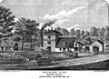
A depiction of Millbourne Mills by Nathan Sellers
-
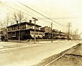
Residential homes in the 1920s alongside Market Street.
-

Bangladeshi Festival of Millbourne in 2014
-
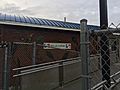
Millbourne Station decorated with iridescent peacock feathers.
-
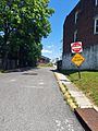
View of Millbourne Station on Wister Drive.


See also
 In Spanish: Millbourne para niños
