
Milltown, New Jersey facts for kids
Quick facts for kids
Milltown, New Jersey
|
|
|---|---|
|
Borough
|
|
| Borough of Milltown | |

Downtown Milltown
|
|

Milltown highlighted in Middlesex County. Inset: Location of Middlesex County in New Jersey.
|
|

Census Bureau map of Milltown, New Jersey
|
|

Milltown, New Jersey
Location in Middlesex County, New Jersey

Milltown, New Jersey
Location in New Jersey

Milltown, New Jersey
Location in the United States
|
|
| Country | |
| State | |
| County | Middlesex |
| Incorporated | January 29, 1889 |
| Government | |
| • Type | Borough |
| • Body | Borough Council |
| Area | |
| • Total | 1.60 sq mi (4.13 km2) |
| • Land | 1.55 sq mi (4.02 km2) |
| • Water | 0.04 sq mi (0.11 km2) 2.56% |
| Area rank | 441st of 565 in state 22nd of 25 in county |
| Elevation | 36 ft (11 m) |
| Population | |
| • Total | 6,893 |
| • Estimate
(2019)
|
6,967 |
| • Rank | 322nd of 566 in state 22nd of 25 in county |
| • Density | 4,443.0/sq mi (1,715.5/km2) |
| • Density rank | 133rd of 566 in state 10th of 25 in county |
| Time zone | UTC−05:00 (Eastern (EST)) |
| • Summer (DST) | UTC−04:00 (Eastern (EDT)) |
| ZIP Code |
08850
|
| Area code(s) | 732 |
| FIPS code | 3402346620 |
| GNIS feature ID | 0885303 |
Milltown is a borough in Middlesex County, New Jersey, United States. The borough is nestled within the heart of the Raritan Valley region, with Lawrence Brook (a Raritan river tributary) flowing through the center of the community. As of the 2010 United States Census, the borough's population was 6,893, reflecting a decrease of 107 (-1.5%) from the 7,000 counted in the 2000 Census, which had in turn increased by 32 (+0.5%) from the 6,968 counted in the 1990 Census.
Milltown was incorporated as a borough by an act of the New Jersey Legislature on January 29, 1889, from portions of North Brunswick, based on the results of a referendum held three days earlier. The borough was reincorporated by resolution of the borough council on May 2, 1896. A portion of East Brunswick Township was annexed in 1902. Originally known as Bergen's Mill, named for Jacob I. Bergen who owned the grist mill, the name is believed to have become "Milltown" from residents "going to the mill in town".
As of the 2000 Census, the center of population for New Jersey was located in Milltown, at Milltown Road, just east of the New Jersey Turnpike (see map of location). Based on the results of the 2010 Census, the center of population had shifted to East Brunswick.
The groundbreaking anxiolytic and sedative drug Miltown (meprobamate) developed by Carter Products, which became available to the public in the mid-1950s, was named for the borough.
Contents
History
Long before the arrival of the first Europeans, the Lenape had established settlements along the Lawrence Brook. The discovery of many artifacts in the area above today's municipal building (now a small county park) suggests the presence of a Native American settlement. In 1678, Thomas Lawrence, a New York baker, acquired a large area around the Lawrence Brook, which likely included today's Milltown. The Lawrence Brook was then called Piscopeek (and on later maps, Lawrence's Brook). The names and marks of several Native Americans (Quemareck, Quesiacs, Isarick, Metapis, Peckawan and Turantaca) appear on the bill of sale. In 1769, Fulcard Van Nordstrand advertised the sale of a large gristmill on the bank of Lawrence Brook. It would soon be called Lawrence Brook Mill. The 1903 classic western film The Great Train Robbery was shot in Milltown.

In March 2010, the Milltown City Council voted against changing the name of Petain Avenue, citing the difficulties that the street's residents would endure if the name changed. Petain Avenue is named for Philippe Pétain, a French World War I general who became the leader of the Vichy France government during World War II. The Vichy Regime willfully collaborated with Nazi Germany, taking state action against "undesirables", including Jews, Protestants, gays, gypsies, and left-wing activists. In total, the Vichy government participated in the deportation of 76,000 Jews to German extermination camps, although this number varies depending on the account; only 2,500 survived the war. After the war, Petain was charged with perjury and sentenced to death, though this was commuted to life imprisonment due to his advanced age. France has since changed the name of every street formerly known as Petain.
Geography
According to the United States Census Bureau, Milltown borough had a total area of 1.596 square miles (4.134 km2), including 1.551 square miles (4.018 km2) of land and 0.045 square mile (0.116 km2) of water (2.80%).
The borough borders North Brunswick Township to the west and East Brunswick Township to the east. The Lawrence Brook, a tributary of the Raritan River, flows through the borough after exiting the Farrington Lake. The dam, under Main Street, creates a reservoir, the Mill Pond.
Climate
The climate in the area is characterized by hot, humid summers and generally mild to cool winters. According to the Köppen Climate Classification system, Milltown has a humid subtropical climate, abbreviated "Cfa" on climate maps.
Demographics
| Historical population | |||
|---|---|---|---|
| Census | Pop. | %± | |
| 1900 | 561 | — | |
| 1910 | 1,584 | 182.4% | |
| 1920 | 2,573 | 62.4% | |
| 1930 | 2,994 | 16.4% | |
| 1940 | 3,515 | 17.4% | |
| 1950 | 3,786 | 7.7% | |
| 1960 | 5,435 | 43.6% | |
| 1970 | 6,470 | 19.0% | |
| 1980 | 7,136 | 10.3% | |
| 1990 | 6,968 | −2.4% | |
| 2000 | 7,000 | 0.5% | |
| 2010 | 6,893 | −1.5% | |
| 2019 (est.) | 6,967 | 1.1% | |
| Population sources: 1900-1920 1900-1910 1910-1930 1930-1990 2000 2010 |
|||
2010 Census
As of the census of 2010, there were 6,893 people, 2,599 households, and 1,915 families residing in the borough. The population density was 4,443.0 per square mile (1,715.5/km2). There were 2,698 housing units at an average density of 1,739.0 per square mile (671.4/km2)*. The racial makeup of the borough was 92.44% (6,372) White, 1.23% (85) Black or African American, 0.13% (9) Native American, 3.37% (232) Asian, 0.00% (0) Pacific Islander, 1.58% (109) from other races, and 1.25% (86) from two or more races. [[Hispanic (U.S. Census)|Hispanic or Latino of any race were 6.46% (445) of the population.
There were 2,599 households out of which 31.1% had children under the age of 18 living with them, 60.9% were married couples living together, 9.3% had a female householder with no husband present, and 26.3% were non-families. 20.7% of all households were made up of individuals, and 8.6% had someone living alone who was 65 years of age or older. The average household size was 2.65 and the average family size was 3.10.
In the borough, the population was spread out with 21.8% under the age of 18, 7.3% from 18 to 24, 26.0% from 25 to 44, 30.1% from 45 to 64, and 14.8% who were 65 years of age or older. The median age was 41.6 years. For every 100 females there were 97.1 males. For every 100 females ages 18 and old there were 93.5 males.
The Census Bureau's 2006-2010 American Community Survey showed that (in 2010 inflation-adjusted dollars) median household income was $89,457 (with a margin of error of +/- $14,398) and the median family income was $103,750 (+/- $7,631). Males had a median income of $63,377 (+/- $5,321) versus $41,029 (+/- $3,358) for females. The per capita income for the borough was $33,472 (+/- $2,034). About 2.9% of families and 3.0% of the population were below the poverty line, including 3.9% of those under age 18 and 5.3% of those age 65 or over.
Transportation
Roads and highways
_from_the_overpass_for_Middlesex_County_Route_606_(South_Main_Street)_in_Milltown,_Middlesex_County,_New_Jersey.jpg)
As of May 2010[update], the borough had a total of 27.37 miles (44.05 km) of roadways, of which 23.74 miles (38.21 km) were maintained by the municipality, 2.59 miles (4.17 km) by Middlesex County and 1.04 miles (1.67 km) by the New Jersey Turnpike Authority.
Ryders Lane (CR 617) is a major artery serving the borough along the eastern border. The New Jersey Turnpike (I-95) passes through for about a mile, but the closest interchange is in neighboring East Brunswick. Also, US 1 is outside in neighboring North Brunswick.
Public transportation
On weekdays, NJ Transit provides local bus service on the 811 route.
Coach USA Suburban Transit provides NYC rush-hour commuter service on the 400 route.
The Raritan River Railroad ran through Milltown, but is now defunct along this part of the line. The track and freight station still remain. Proposals have been made to use the line as a light rail route.
Education
The Milltown Public Schools serves students in public school for pre-kindergarten through eighth grade. As of the 2017–18 school year, the district, comprised of two schools, had an enrollment of 755 students and 63.6 classroom teachers (on an FTE basis), for a student–teacher ratio of 11.9:1. Schools in the district (with 2017-18 enrollment data from the National Center for Education Statistics) are Parkview School (335 students; in grades PreK-3) and Joyce Kilmer School (411 students; in grades 4-8).
For ninth through twelfth grades, public school students attend Spotswood High School in Spotswood as part of a sending/receiving relationship with the Spotswood Public Schools, which also serves students from Helmetta. In 2013, Milltown and Spotswood had discussions of expanding the partnership between the two districts beyond the sending relationship. As of the 2017–18 school year, the high school had an enrollment of 679 students and 58.0 classroom teachers (on an FTE basis), for a student–teacher ratio of 11.7:1.
The community is also served by the Greater Brunswick Charter School, a K-8 charter school serving students from Milltown, Edison, Highland Park and New Brunswick. As of the 2017–18 school year, the school had an enrollment of 395 students and 33.0 classroom teachers (on an FTE basis), for a student–teacher ratio of 12.0:1.
Eighth grade students from all of Middlesex County are eligible to apply to attend the high school programs offered by the Middlesex County Vocational and Technical Schools, a county-wide vocational school district that offers full-time career and technical education at Middlesex County Academy in Edison, the Academy for Allied Health and Biomedical Sciences in Woodbridge and at its East Brunswick, Perth Amboy and Piscataway technical high schools, with no tuition charged to students for attendance.
Our Lady of Lourdes School (PreK-8) operates under the supervision of Roman Catholic Diocese of Metuchen.
Notable people
People who were born in, residents of, or otherwise closely associated with Milltown include:
- J. Edward Crabiel (1916-1992), politician who served in the New Jersey Senate and as New Jersey Secretary of State, until forced to resign.
- Josephine Figlo (1923–2011), All-American Girls Professional Baseball League outfielder who played for the Milwaukee Chicks and Racine Belles in 1944.
- Al Hermann (1899-1980), Major League Baseball infielder who played for the Boston Braves.
- David Kikoski (born 1961), jazz pianist.
- Leroy Lins (1913-1986), professional basketball player who played for the Akron Goodyear Wingfoots in the National Basketball League.
- Danny Pintauro (born 1976), actor who got started as a child actor on the television soap opera As the World Turns, and in the movie Cujo, and came to prominence on the television series Who's the Boss?.
- Peter Plantec (born 1943), writer, digital artist and software designer.
- David Schwendeman (1924–2012), last full-time chief taxidermist of the American Museum of Natural History from 1959 to 1988, who was a lifelong resident of Milltown.
- Geno Zimmerlink (born 1963), former American football tight end who played for the Atlanta Falcons of the National Football League.
Images for kids
-
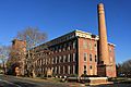
The Milltown India Rubber Factory, now condominiums
.jpg)
See also
 In Spanish: Milltown (Nueva Jersey) para niños
