
Miyako, Iwate facts for kids
Quick facts for kids
Miyako
宮古市
|
||
|---|---|---|
|
City
|
||

Top left: Cape of Dodo and lighthouse, Top right: Miyako Bay from satellite, 2nd row: Mount Hayachine, lower left: Jyodo Beach, lower right: Rock of Sano, Bottom left: Tago Port, Bottom right: Rock of Rosoku (Candle)
|
||
|
||

Location of Miyako in Iwate
|
||
| Country | Japan | |
| Region | Tōhoku | |
| Prefecture | Iwate | |
| Area | ||
| • Total | 696.82 km2 (269.04 sq mi) | |
| Population
(April 2008)
|
||
| • Total | 57,874 | |
| • Density | 83.1/km2 (215/sq mi) | |
| Time zone | UTC+9 (Japan Standard Time) | |
| - Tree | Japanese Red Pine | |
| - Flower | Montauk Daisy (Nipponanthemum nipponicum) | |
| - Bird | Black-tailed Gull | |
| - Fish | Salmon | |
| Phone number | 0193-62-2111 | |
| Address | 2-1 Shinkawachō, Miyako-shi, Iwate-ken 027-8501 |
|

Miyako (宮古市, Miyako-shi) is a city in Iwate Prefecture, Japan. It was founded on February 11, 1941.
The city is along the coast where the Hei River (閉伊川, Heigawa) flows into the Pacific Ocean. It is connected to Morioka by an east-west train line and highway and the coastal highway also goes through the town. The city has a port but much of the shipping traffic is taken by larger cities along the coast.
On June 6, 2005, the old Miyako absorbed the town of Tarō and village of Niisato from Shimohei District to form the new city of Miyako, more than doubling the old city's size. As of 2008, the new city had an estimated population of 57,874 and a density of 83.1 persons per km². The total area is 696.82 km².
On January 1, 2010, the city absorbed another Shimohei District village, Kawai.
2011 tsunami
On March 11, 2011, the city was devastated by a tsunami caused by the 2011 Tōhoku earthquake. At least 401 lives were lost. Only about 30–60 boats survived from the town's 960 ship fishing fleet. A study by the University of Tokyo's Earthquake Research Institute found that the waters had reached at least 37.9 metres (124 ft) above sea level. This was almost as high the 38.2 metres (125 ft) record of the 1896 Meiji-Sanriku earthquake tsunami.
Some of the most well known scenes of the 2011 Japanese tsunami, broadcast worldwide, were shot in Miyako. It shows a dark black wave cresting and overflowing a floodwall and tossing cars, followed by a fishing boat capsizing as it hit the floodwall and then crushed as it was forced under a bridge.
Images for kids
-
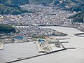
Downtown of Miyako

See also
 In Spanish: Miyako (Iwate) para niños
