
Monett, Missouri facts for kids
Quick facts for kids
Monett, Missouri
|
|
|---|---|

Monett Downtown facing west
|
|
| Motto(s):
Pride & Progress
|
|

Location of Monett, Missouri
|
|
| Country | United States |
| State | Missouri |
| Counties | Barry, Lawrence |
| Township | Monett, Pierce |
| Founded | 1870 |
| Incorporated | 1887 |
| Area | |
| • Total | 8.53 sq mi (22.10 km2) |
| • Land | 8.51 sq mi (22.04 km2) |
| • Water | 0.02 sq mi (0.06 km2) |
| Elevation | 1,378 ft (420 m) |
| Population
(2020)
|
|
| • Total | 9,576 |
| • Density | 1,072.02/sq mi (413.91/km2) |
| Demonym(s) | Monettian |
| Time zone | UTC-6 (Central (CST)) |
| • Summer (DST) | UTC-5 (CDT) |
| ZIP code |
65708
|
| Area code(s) | 417 |
| FIPS code | 29-49196 |
Monett is the most-populous city in the Barry and Lawrence counties in the U.S. state of Missouri. The city is located in the Ozarks, just south of Interstate 44 between Joplin and Springfield. According to the 2020 census, the population of the town was estimated to be 9,576 individuals.
Contents
History
Monett was created as a railroad town by the St. Louis–San Francisco Railway ("Frisco Line") which came through in 1870 and would build branch going off the main line to Paris, Texas. Both lines are still in existence and operated by the BNSF Railway. During this time the area went through several names including Kings Prairie Depot, Plymouth, Plymouth Junction (when the southern branch was built in 1880), Gonten (named for the local post master because the Post Service said there were other Plymouths); and finally Monett in 1887 when the area was formally platted and the Monett name was applied to the post office. It was named for Henry Monett who was a popular general station agent for various railroads including the New York, Chicago and St. Louis Railroad ("Nickel Plate Railroad") before becoming an agent for the New York Central Railroad shortly before his death at the age of 35 in 1888.
The community was very much noted for being a rail town and had a Harvey House operating at the Frisco train station from 1896 until 1930. The community in the Ozark Mountains also had a thriving fruit business and was nicknamed the "Strawberry Capital of the Midwest." The Ozark Fruit Growers Association building (built in 1927) which is part of the Downtwon Monett Historic District is on the National Register of Historic Places.
The David W. Courdin House, Downtown Monett Historic District, and Waldensian Church and Cemetery of Stone Prairie are listed on the National Register of Historic Places.
Geography
Monett is located at 36°55′25″N 93°55′20″W / 36.92361°N 93.92222°W (36.923725, -93.922332).
According to the United States Census Bureau, the city has a total area of 8.45 square miles (21.89 km2), of which 8.43 square miles (21.83 km2) is land and 0.02 square miles (0.05 km2) is water.
Demographics
| Historical population | |||
|---|---|---|---|
| Census | Pop. | %± | |
| 1890 | 1,699 | — | |
| 1900 | 3,115 | 83.3% | |
| 1910 | 4,177 | 34.1% | |
| 1920 | 4,206 | 0.7% | |
| 1930 | 4,099 | −2.5% | |
| 1940 | 4,395 | 7.2% | |
| 1950 | 4,771 | 8.6% | |
| 1960 | 5,359 | 12.3% | |
| 1970 | 5,937 | 10.8% | |
| 1980 | 6,148 | 3.6% | |
| 1990 | 6,529 | 6.2% | |
| 2000 | 7,396 | 13.3% | |
| 2010 | 8,873 | 20.0% | |
| 2020 | 9,576 | 7.9% | |
| U.S. Decennial Census | |||
2010 census
As of the census of 2010, there were 8,873 people, 3,405 households, and 2,282 families residing in the city. The population density was 1,052.6 inhabitants per square mile (406.4/km2). There were 3,828 housing units at an average density of 454.1 per square mile (175.3/km2). The racial makeup of the city was 86.8% White, 0.8% African American, 0.9% Native American, 1.0% Asian, 0.1% Pacific Islander, 8.5% from other races, and 1.9% from two or more races. Hispanic or Latino of any race were 19.0% of the population.
There were 3,405 households, of which 36.8% had children under the age of 18 living with them, 48.8% were married couples living together, 12.7% had a female householder with no husband present, 5.6% had a male householder with no wife present, and 33.0% were non-families. 27.9% of all households were made up of individuals, and 11.2% had someone living alone who was 65 years of age or older. The average household size was 2.57 and the average family size was 3.12.
The median age in the city was 34 years. 27.8% of residents were under the age of 18; 9% were between the ages of 18 and 24; 26.6% were from 25 to 44; 22.1% were from 45 to 64; and 14.5% were 65 years of age or older. The gender makeup of the city was 48.1% male and 51.9% female.
Climate
Climate is characterized by relatively high temperatures and evenly distributed precipitation throughout the year. The Köppen Climate Classification subtype for this climate is "Cfa" (Humid Subtropical Climate).
| Climate data for Monett, Missouri | |||||||||||||
|---|---|---|---|---|---|---|---|---|---|---|---|---|---|
| Month | Jan | Feb | Mar | Apr | May | Jun | Jul | Aug | Sep | Oct | Nov | Dec | Year |
| Average high °C (°F) | 8 (46) |
10 (50) |
14 (57) |
22 (71) |
26 (78) |
30 (86) |
32 (90) |
32 (90) |
28 (83) |
23 (73) |
15 (59) |
9 (49) |
21 (69) |
| Average low °C (°F) | −5 (23) |
−3 (26) |
0 (32) |
7 (45) |
13 (55) |
17 (63) |
20 (68) |
18 (65) |
14 (58) |
8 (47) |
2 (35) |
−3 (27) |
7 (45) |
| Average precipitation mm (inches) | 38 (1.5) |
56 (2.2) |
81 (3.2) |
110 (4.2) |
120 (4.9) |
120 (4.7) |
91 (3.6) |
71 (2.8) |
110 (4.2) |
76 (3) |
66 (2.6) |
66 (2.6) |
1,000 (39.4) |
| Average precipitation days | 5 | 6 | 8 | 9 | 9 | 8 | 7 | 7 | 6 | 6 | 7 | 6 | 84 |
| Source: Weatherbase | |||||||||||||
- Historic maps of Monett in the Sanborn Maps of Missouri Collection at the University of Missouri
Economy
Monett's economy is based on manufacturing, financial services, software, retail and education. This community is driven primarily by its industrial sector. Several key businesses in town include Jack Henry & Associates, CoxHealth, Tyson Foods, Miracle Recreation Equipment Company, Schreiber Foods, Hydro Aluminum, International Dehydrated Foods, Miracle, Architectural Systems Inc., EFCO, and WinTech.
The town has seen rapid growth over the last two decades. More recently, heavy investment into Monett's Historical Downtown has brought new life to many businesses, and the area's cultural scene.
Monett is a part of the Southwest Missouri Council of Governments (SMCOG), providing urban planning and economic development resources for the ten county region around the Springfield metropolitan area, Missouri.
Education
Public
Monett is part of the Monett R-1 School District. The district has the following schools:
- Monett High School
- Scott Regional Technology Center
- Monett Middle School
- Monett Intermediate School
- Central Park Elementary
- Monett Elementary
Missouri Schools for the Severely Disabled (MSSD) is a state operated program serving Missouri students with severe disabilities in the greater Monett area at:
- Oakview State School K-12
Private
The private schools in Monett include Berean Christian Academy and St. Lawrence Catholic Elementary.
Higher education
Downtown Monett is home to a satellite campus of Drury University.
Library
Monett has a public library, a branch of the Barry-Lawrence Regional Library.
Transportation
Highways
Monett is at the crossroads of U.S. Route 60 and Missouri Route 37, connecting the town to Interstate 44 and the metropolitan areas of Joplin, Springfield and Northwest Arkansas.
.jpg)
Airport
The Monett Municipal Airport (HFJ) is a public use airport, registering 18,100 aircraft operations annually in 2008. In the 2012 economic impact study conducted by the Missouri Department of Transportation, The Airport ranked 9th in the state of Missouri with a total output of 13.1 million dollars annually.
Railroads
Monett was once a thriving depot used by the St. Louis–San Francisco Railway, today it is served by the BNSF Railway and the Arkansas and Missouri Railroad.
Notable people
- Ginny Duenkel, known by her married name Ginny Fuldner; 1964 Olympic gold medalist and former Olympic record-holding swimmer
- Jack Henry, founder of Jack Henry & Associates, S&P 500 financial services company headquartered in Monett
- Phil Mulkey, track and field athlete
- Sally Shelton-Colby, U.S. Ambassador to Barbados, Grenada and Dominica
- Howard F. Stone, lieutenant general in the U.S. Army
Images for kids
-
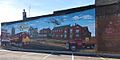
History of Monett in a mural downtown
-
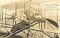
Logan McKee flying the DeChenne Aeroplane in Monett, Missouri
-
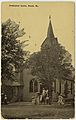
The Presbyterian Church in Monett, Missouri
-
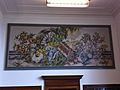
WPA mural, Products of Missouri by James McCreery, in Monett post office


See also
 In Spanish: Monett (Misuri) para niños
