
Mongarlowe, New South Wales facts for kids
Quick facts for kids MongarloweNew South Wales |
|||||||||||||||
|---|---|---|---|---|---|---|---|---|---|---|---|---|---|---|---|
 |
|||||||||||||||

Mongarlowe
Location in New South Wales
|
|||||||||||||||
| Population | 117 (2016 census) | ||||||||||||||
| Postcode(s) | 2622 | ||||||||||||||
| Location | 13 km (8 mi) from Braidwood | ||||||||||||||
| LGA(s) | Queanbeyan-Palerang Regional Council | ||||||||||||||
| Region | Southern Tablelands | ||||||||||||||
| County | St Vincent | ||||||||||||||
| Parish | Budawang | ||||||||||||||
| State electorate(s) | Monaro | ||||||||||||||
| Federal Division(s) | Eden-Monaro | ||||||||||||||
|
|||||||||||||||
Mongarlowe is a village in the Southern Tablelands of New South Wales, Australia in Queanbeyan-Palerang Regional Council. In former times, it was also known, in various contexts, as Little River, Monga, and Sergeants Point.
Location and features
It is situated on the Mongarlowe River and about 13 km east of Braidwood. It currently has a population of around 50 but was much larger during the mid-19th century due to the New South Wales gold rush. Several buildings from this time have survived. Another population boom followed during the Depression when many returned to distill eucalyptus oil and search again for gold.
There was a proposal for a 98 lot subdivision in proximity to the village which was cancelled in 2008 under pressure from concerned residents.
Images for kids
-
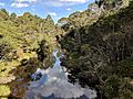
Mongarlowe river in Mongarlowe
-
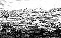
Village c.1870, with Chinese temple in the foreground.and river crossing at centre.

.jpg)
