Monona County, Iowa facts for kids
Quick facts for kids
Monona County
|
|
|---|---|

|
|

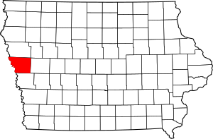
Location within the U.S. state of Iowa
|
|
 Iowa's location within the U.S. |
|
| Country | |
| State | |
| Founded | 1851 |
| Seat | Onawa |
| Largest city | Onawa |
| Area | |
| • Total | 699 sq mi (1,810 km2) |
| • Land | 694 sq mi (1,800 km2) |
| • Water | 4.9 sq mi (13 km2) 0.7% |
| Population
(2020)
|
|
| • Total | 8,751 |
| • Density | 12.519/sq mi (4.834/km2) |
| Time zone | UTC−6 (Central) |
| • Summer (DST) | UTC−5 (CDT) |
| Congressional district | 4th |
Monona County is a county located in the U.S. state of Iowa. As of the 2020 census, the population was 8,751. The county seat is Onawa.
Contents
History
Monona County was formed in 1851. It was perhaps named for the Indian word meaning "beautiful valley."
When Ashton (originally called Bloomfield ) was named the county seat in the fall of 1854, a log house served as the first courthouse. Ashton remained the county seat for only four years. On April 5, 1858, Onawa was voted the permanent seat of the county.
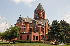
The first Monona County Courthouse was completed in 1858.
Geography
According to the U.S. Census Bureau, the county has a total area of 699 square miles (1,810 km2), of which 694 square miles (1,800 km2) is land and 4.9 square miles (13 km2) (0.7%) is water.
Major highways
 Interstate 29
 Iowa Highway 37
 Iowa Highway 141
 Iowa Highway 175
 Iowa Highway 183
Adjacent counties
- Woodbury County (north)
- Crawford County (east)
- Harrison County (south)
- Burt County, Nebraska (southwest)
- Thurston County, Nebraska (west)
Demographics
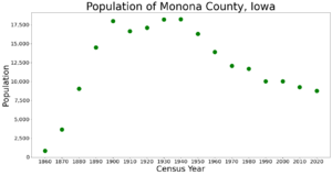
| Historical population | |||
|---|---|---|---|
| Census | Pop. | %± | |
| 1860 | 832 | — | |
| 1870 | 3,654 | 339.2% | |
| 1880 | 9,055 | 147.8% | |
| 1890 | 14,515 | 60.3% | |
| 1900 | 17,980 | 23.9% | |
| 1910 | 16,633 | −7.5% | |
| 1920 | 17,125 | 3.0% | |
| 1930 | 18,213 | 6.4% | |
| 1940 | 18,238 | 0.1% | |
| 1950 | 16,303 | −10.6% | |
| 1960 | 13,916 | −14.6% | |
| 1970 | 12,069 | −13.3% | |
| 1980 | 11,692 | −3.1% | |
| 1990 | 10,034 | −14.2% | |
| 2000 | 10,020 | −0.1% | |
| 2010 | 9,243 | −7.8% | |
| 2020 | 8,751 | −5.3% | |
| U.S. Decennial Census 1790-1960 1900-1990 1990-2000 2010-2018 |
|||
2020 census
The 2020 census recorded a population of 8,751 in the county, with a population density of 12.5221/sq mi (4.8348/km2). 96.03% of the population reported being of one race. 90.33% were non-Hispanic White, 0.32% were Black, 2.70% were Hispanic, 1.67% were Native American, 0.32% were Asian, 0.02% were Native Hawaiian or Pacific Islander and 4.64% were some other race or more than one race. There were 4,373 housing units, of which 3,839 were occupied.
2010 census
The 2010 census recorded a population of 9,243 in the county, with a population density of 13.3354/sq mi (5.1488/km2). There were 4,697 housing units, of which 4,050 were occupied.
Communities
Population ranking
The population ranking of the following table is based on the 2010 census of Monona County.
† county seat
| Rank | City/Town/etc. | Municipal type | Population (2010 Census) |
|---|---|---|---|
| 1 | † Onawa | City | 2,998 |
| 2 | Mapleton | City | 1,224 |
| 3 | Whiting | City | 762 |
| 4 | Ute | City | 374 |
| 5 | Moorhead | City | 226 |
| 6 | Blencoe | City | 224 |
| 7 | Soldier | City | 174 |
| 8 | Castana | City | 147 |
| 9 | Turin | City | 68 |
| 10 | Rodney | City | 60 |
See also
 In Spanish: Condado de Monona para niños


