
Monroe, Massachusetts facts for kids
Quick facts for kids
Monroe, Massachusetts
|
||
|---|---|---|

Monroe Town Hall
|
||
|
||

Location in Franklin County in Massachusetts
|
||
| Country | United States | |
| State | Massachusetts | |
| County | Franklin | |
| Settled | 1800 | |
| Incorporated | 1822 | |
| Government | ||
| • Type | Open town meeting | |
| Area | ||
| • Total | 10.8 sq mi (27.9 km2) | |
| • Land | 10.7 sq mi (27.7 km2) | |
| • Water | 0.08 sq mi (0.2 km2) | |
| Population
(2020)
|
||
| • Total | 118 | |
| • Density | 10.95/sq mi (4.229/km2) | |
| Time zone | UTC-5 (Eastern) | |
| • Summer (DST) | UTC-4 (Eastern) | |
| ZIP code |
01350
|
|
| Area code(s) | 413 | |
| FIPS code | 25-42040 | |
| GNIS feature ID | 0618170 | |

Monroe is a town in Franklin County, Massachusetts, United States. The population was 118 at the 2020 census. By area, population, and population density, it is the smallest town in the county; and is the second-smallest town by population in the Commonwealth, with only Gosnold having fewer residents.
Monroe is part of the Springfield, Massachusetts Metropolitan Statistical Area.
Contents
History
Monroe was first settled in 1800 and was officially incorporated in 1822. The town was named for President James Monroe, who was in office at the time of incorporation. The town was mostly rural, with dairy farming taking up much of the town's economic activity. During the mid-19th century, the town did get some business from the building of the Hoosac Tunnel, just south of town in Florida. In 1885, however, a railroad line was built between neighboring Readsboro, Vermont, and Holyoke to haul wood pulp to a paper factory. This, in turn, enticed the Ramage family to establish the James Ramage Paper Company in 1887. The company was the main industry well into the 20th century, before closing in 1984.
Geography
According to the United States Census Bureau, the town has a total area of 10.8 square miles (28 km2), of which 10.7 square miles (28 km2) is land and 0.1 square miles (0.26 km2), or 0.65%, is water. Monroe is located at 42° 43'18.80"N, 72° 56'29.38"W. The town is located on the northwestern corner of Franklin County along the Vermont state border, and is bordered by Berkshire County to the west and Bennington County, Vermont, to the north. It is bordered on the north by the towns of Stamford and Readsboro, Vermont, on the east by Rowe, and on the south and west by Florida. Monroe is 26 miles (42 km) northwest of Greenfield, 55 miles (89 km) north-northwest of Springfield, and 115 miles (185 km) west-northwest of Boston.
Monroe is located on the Hoosac Range, the northern end of The Berkshires. The town's border with Rowe lies along the Deerfield River, which enters the state at this point, heading south and eastward towards the Connecticut River. The river is dammed for part of this length as the southern end of the Sherman Reservoir, which formerly supplied power to the Yankee Rowe Nuclear Power Station. There are also several brooks which run through town. Much of the central and southern part of town is covered by Monroe State Forest, which extends into neighboring Florida.
Monroe is one of a handful of towns in the state without any state highways (half of these are on Martha's Vineyard and Nantucket). The nearest state highway is Massachusetts Route 2, also known as the Mohawk Trail, which runs through the neighboring towns. The nearest expressway is Interstate 91, which runs along the Connecticut River, 28 miles (45 km) east of town. The nearest regional rail, bus, and air service can be found in North Adams, and the nearest national air service is at Albany International Airport in New York.
Demographics
| Historical population | ||
|---|---|---|
| Year | Pop. | ±% |
| 1840 | 260 | — |
| 1850 | 254 | −2.3% |
| 1860 | 236 | −7.1% |
| 1870 | 201 | −14.8% |
| 1880 | 166 | −17.4% |
| 1890 | 282 | +69.9% |
| 1900 | 305 | +8.2% |
| 1910 | 246 | −19.3% |
| 1920 | 173 | −29.7% |
| 1930 | 218 | +26.0% |
| 1940 | 207 | −5.0% |
| 1950 | 174 | −15.9% |
| 1960 | 210 | +20.7% |
| 1970 | 216 | +2.9% |
| 1980 | 179 | −17.1% |
| 1990 | 115 | −35.8% |
| 2000 | 93 | −19.1% |
| 2010 | 121 | +30.1% |
| 2020 | 118 | −2.5% |
Source: United States Census records and Population Estimates Program data. |
||
Monroe is the smallest town by population and population density in Franklin County, and second smallest in Massachusetts. As of the census of 2000, there were 93 people, 43 households, and 23 families residing in the town. The population density was 8.7 people per square mile (3.4/km2). There were 67 housing units at an average density of 6.3 per square mile (2.4/km2). The racial makeup of the town was 100.00% White.
There were 43 households, out of which 32.6% had children under the age of 18 living with them, 27.9% were married couples living together, 16.3% had a female householder with no husband present, and 44.2% were non-families. Of all households 37.2% were made up of individuals, and 14.0% had someone living alone who was 65 years of age or older. The average household size was 2.16 and the average family size was 2.83.
In the town, the population was spread out, with 24.7% under the age of 18, 8.6% from 18 to 24, 23.7% from 25 to 44, 25.8% from 45 to 64, and 17.2% who were 65 years of age or older. The median age was 41 years. For every 100 females, there were 86.0 males. For every 100 females age 18 and over, there were 79.5 males.
The median income for a household in the town was $25,500, and the median income for a family was $21,250. Males had a median income of $23,750 versus $28,125 for females. The per capita income for the town was $12,400. There were 37.5% of families and 21.8% of the population living below the poverty line, including 30.8% of under eighteens and 26.7% of those 65 or older. It has the lowest per capita income for any town in Massachusetts.
Education
Monroe does not have its own schools. Students attend the Abbott Memorial School in Florida, Massachusetts between pre-kindergarten and eighth grades, and Drury High School in North Adams for ninth through twelfth grades. Students also have the option of attending C.H. McCann Technical School for high school, as well as the private and religious schools in the North Adams area for all grades.
The nearest community college, Greenfield Community College, is located in Greenfield. The nearest state college is Massachusetts College of Liberal Arts in North Adams, and the nearest state university is the University of Massachusetts Amherst. The nearest private college is Williams College in Williamstown.
-
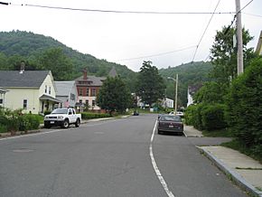
On Depot St. looking west towards town hall
-
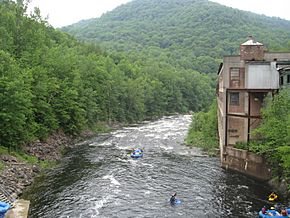
Monroe on the right (west bank), Rowe on the left (east) bank
-
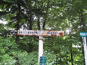
At the state line
-
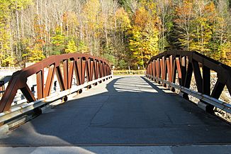
Monroe Bridge


See also
 In Spanish: Monroe (Massachusetts) para niños
