
Monroe, Washington facts for kids
Quick facts for kids
Monroe
|
|
|---|---|

Main Street and Lewis Street in downtown Monroe
|
|

Location of Monroe, Washington
|
|
| Country | United States |
| State | Washington |
| County | Snohomish |
| Founded | 1864 |
| Incorporated | December 20, 1902 |
| Government | |
| • Type | Mayor–council |
| Area | |
| • Total | 6.16 sq mi (15.95 km2) |
| • Land | 6.10 sq mi (15.79 km2) |
| • Water | 0.06 sq mi (0.16 km2) |
| Elevation | 72 ft (22 m) |
| Population
(2010)
|
|
| • Total | 17,304 |
| • Estimate
(2019)
|
19,776 |
| • Density | 3,243.56/sq mi (1,252.39/km2) |
| Time zone | UTC-8 (Pacific (PST)) |
| • Summer (DST) | UTC-7 (PDT) |
| ZIP code |
98272
|
| Area code | 360 |
| FIPS code | 53-46685 |
| GNIS feature ID | 1523319 |
Monroe is a city in Snohomish County, Washington, United States. It is located at the confluence of the Skykomish, Snohomish, and Snoqualmie rivers near the Cascade foothills, about 30 miles (48 km) northeast of Seattle. Monroe's population was 17,304 as of the 2010 census and was estimated to be 19,776 in 2019.
Monroe was originally founded in 1864 as the town of Park Place, located at the river confluence among several existing settlements in the Tualco Valley. The townsite was previously a trading post used by the indigenous Skykomish people. Park Place was renamed to Monroe in 1890 to honor U.S. President James Monroe, and was moved northeast to be near the tracks of the Great Northern Railway, which was constructed in 1892. Monroe was incorporated in 1902 and was selected as the home of a major condensed milk plant and the state reformatory.
Monroe became a suburban bedroom community in the late 20th century, serving commuters to Everett, Seattle, and the Eastside. It is home to the Monroe Correctional Complex, which absorbed the original reformatory in 1998, and the Evergreen State Fair, which runs annually in late summer. The city is located at the junction of two highways, U.S. Route 2 and State Route 522, which were expanded in the late 20th century to serve commuters.
Contents
History
The history of Monroe is intertwined with that of the Great Northern Railway which pushed over the Cascade Range at Stevens Pass and worked its way down the Skykomish River Valley.
Prior to that time the main settlement in the area had been located about one mile west of where the downtown eventually grew up and was known as Park Place. However, the city's merchants relocated when the railroad survey was completed to have better access to the new transportation corridor. The new development was originally known as Tye City, but became Monroe when Park Place's main store, the one containing the U.S. Post Office, relocated and took up the name "Monroe at Park Place" in honor of James Monroe, the nation's fifth president. Because the U.S. Postal Department would not allow any new post offices to use double names, the post office, and eventually the town, became known simply as "Monroe."
By 1893 the city had become an important stop on the rail line and was best known for the GN Greenhouses, which grew flowers for the passengers to purchase. That same year, Snohomish County built the County Poor Farm where today's Evergreen State Fairgrounds are located; the city's first hospital was built where Valley General Hospital stands today. 1894 saw the construction of the first high bridge over the Skykomish River and 1896 the construction of the first church. In 1899 the grammar school was relocated from its old site in Park Place to a new site in Monroe and the town's newspaper, The Monroe Monitor, began publication on January 14 of the same year. On September 16, 1901 a fire destroyed the only complete block of business in the city. The city was shaken by that, but quickly built back up. Nowadays, the town of Monroe has a population of 17,286 residents, with thriving small businesses. On the old area of Park Place is Park Place Middle School, there for its dedication. The town of Monroe contains a small little library, and the Monte Cristo Railroad crosses through it.

The economic area of the city saw a series of development as well. While the city was still in its infancy, many sawmills were constructed to take advantage of the area's old growth cedar and cedar shakes became the main product. However, as the timber played out and the logging industry slowly moved away, agriculture became the area's new industry and berry farms began to flourish. Because of the lush valley grasses, dairy farms too moved into the area and soon several creameries began production. Evidence of this industry can still be seen today as the giant smokestack of the Carnation Condensery, a factory which was destroyed by fire in the 1940s, still stands in the middle of what is today a grocery store parking lot at the intersection of Main Street and US Route 2. It is a lone reminder of this forgotten industrial era and, despite its age, it remains much taller than any other structure in the city.

The City of Monroe officially voted to incorporate on December 20, 1902 and the new city counted 325 people in its population. In 1910, around the same time as the construction of the Carnation Condensery, Washington State chose Monroe as the site of the Washington State Reformatory.
The Great Depression struck Monroe as it did elsewhere in the nation and much of the town's industry closed down. As a result, the city fathers applied for national funds and established programs to help the town. The funds built a school, which can still be seen on Main Street, as well as road improvements. In 1941, the first fair was held in Monroe, known as the Cavalcade of the Valleys, at the County Poor Farm. Although interrupted by World War II, the fair resumed in 1946 with the help of many local residents such as Mr. and Mrs. Shine Peters, then owners of Monroe Floral, who helped plant all the flowers shrubs and trees that decorated the grounds from their nursery. Local farmers and Grange members' contributions helped establish many traditions the Evergreen State Fair continues to take pride in. The annual fair remains an important part of the city's culture today.

After the depression and war, industry did not return to the city and the town became ever more oriented towards agriculture. It continued to grow, albeit slowly, throughout much of the 1950s and '60s. In April 1965 a major earthquake struck Western Washington and the original Monroe High School and its annex were so severely damaged that they later had to be demolished. The new high school opened in 1968 and served the city until a new, larger high school had to be built in 1999.
In the early 1970s Monroe became the terminus for State Route 522 (Originally SR202, before being realigned into SR522), which offers a more direct connection to Interstate 405 and larger cities to the south. This has opened the city up and helped to establish it as a true bedroom community. The highway meets up with U.S. Route 2 in the town and the intersection is often filled with intrastate traffic.

During the first decade of the 21st century, Monroe saw growth in unexpected new proportions as many large strip malls and major retailers have built new complexes along Highway 2. The city's residential areas have greatly expanded as well and the highway has become the scene of major gridlock, especially during summer months and major holidays. At the time of this writing, a bypass is being considered but no firm plans have been agreed upon.
The new developments have added to the city and the influx of people into the surrounding area has changed, but not erased much of the city's charm. The old part of town stands much as it always has, on Main Street away from the busy highway, and has managed to preserve much of its small town character. Trains still regularly pass through the town on their way across Stevens Pass and the sound of their horns is a common feature of life in the city.
Since 2007, Monroe's Old Town district has begun a revitalization program.
Monroe has also been host to a few Hollywood films, such as The Ring (2002), The Ring Two (2005), and The Butterfly Effect (2004).
Once per year from 1995 until 2000, the NASCAR Craftsman Truck Series held a race at the Evergreen Speedway located at the Evergreen State Fairgrounds.
Geography
Monroe is located at 47°51′28″N 121°59′18″W / 47.857722°N 121.988364°W (47.857722, -121.988364).
According to the United States Census Bureau, the city has a total area of 6.11 square miles (15.82 km2), of which, 6.05 square miles (15.67 km2) is land and 0.06 square miles (0.16 km2) is water.
Climate
The climate in this area has mild differences between highs and lows, and there is adequate rainfall year-round. According to the Köppen Climate Classification system, Monroe has a warm-summer Mediterranean climate, abbreviated "Csb" on climate maps.
| Climate data for Monroe | |||||||||||||
|---|---|---|---|---|---|---|---|---|---|---|---|---|---|
| Month | Jan | Feb | Mar | Apr | May | Jun | Jul | Aug | Sep | Oct | Nov | Dec | Year |
| Record high °F (°C) | 72 (22) |
75 (24) |
79 (26) |
85 (29) |
94 (34) |
96 (36) |
102 (39) |
101 (38) |
97 (36) |
88 (31) |
77 (25) |
66 (19) |
102 (39) |
| Average high °F (°C) | 44.9 (7.2) |
49.6 (9.8) |
53.8 (12.1) |
59.9 (15.5) |
66.1 (18.9) |
70.9 (21.6) |
76.4 (24.7) |
76.3 (24.6) |
70.7 (21.5) |
60.8 (16.0) |
50.6 (10.3) |
45.2 (7.3) |
60.4 (15.8) |
| Average low °F (°C) | 32.7 (0.4) |
34 (1) |
36.4 (2.4) |
39.8 (4.3) |
44.7 (7.1) |
49.5 (9.7) |
52 (11) |
52.2 (11.2) |
48.5 (9.2) |
43 (6) |
37.2 (2.9) |
34 (1) |
42 (6) |
| Record low °F (°C) | −3 (−19) |
−2 (−19) |
12 (−11) |
23 (−5) |
29 (−2) |
34 (1) |
33 (1) |
39 (4) |
30 (−1) |
21 (−6) |
1 (−17) |
1 (−17) |
−3 (−19) |
| Average precipitation inches (mm) | 6.25 (159) |
4.5 (110) |
4.8 (120) |
3.54 (90) |
3.11 (79) |
2.52 (64) |
1.24 (31) |
1.55 (39) |
2.55 (65) |
4.52 (115) |
6.56 (167) |
6.66 (169) |
47.8 (1,210) |
| Average snowfall inches (cm) | 3.1 (7.9) |
1 (2.5) |
0.7 (1.8) |
0.1 (0.25) |
0 (0) |
0 (0) |
0 (0) |
0 (0) |
0 (0) |
0 (0) |
0.6 (1.5) |
2.4 (6.1) |
8 (20) |
| Average precipitation days | 21 | 17 | 19 | 16 | 13 | 11 | 6 | 7 | 10 | 16 | 20 | 21 | 177 |
Demographics
| Historical population | |||
|---|---|---|---|
| Census | Pop. | %± | |
| 1910 | 1,552 | — | |
| 1920 | 1,675 | 7.9% | |
| 1930 | 1,570 | −6.3% | |
| 1940 | 1,590 | 1.3% | |
| 1950 | 1,556 | −2.1% | |
| 1960 | 1,901 | 22.2% | |
| 1970 | 2,687 | 41.3% | |
| 1980 | 2,869 | 6.8% | |
| 1990 | 4,278 | 49.1% | |
| 2000 | 13,795 | 222.5% | |
| 2010 | 17,304 | 25.4% | |
| 2019 (est.) | 19,776 | 14.3% | |
| U.S. Decennial Census U.S. Census Estimate (2019) |
|||
Monroe is the tenth largest city in Snohomish County by population, with an estimated 19,363 residents in 2018. It has a large Hispanic and Latino population that trends higher than the rest of the county. The city's population grew rapidly in the years after it incorporated in 1902, but leveled off under 2,000 until the 1970s. Suburban development following the completion of State Route 522 and expansion of U.S. Route 2 caused large increases in Monroe's population, peaking in the 1990s and early 2000s. The inmate population at the Monroe Correctional Complex has been included in census statistics since 1996. Over 65 percent of homes in Monroe are single-family detached structures, while over 15 percent are multi-family residential units.
2010 census
As of the 2010 census, there were 17,304 people, 5,024 households, and 3,600 families residing in the city. The population density was 2,860.2 inhabitants per square mile (1,104.3/km2). There were 5,306 housing units at an average density of 877.0 per square mile (338.6/km2). The racial makeup of the city was 78.6% White, 3.5% African American, 1.4% Native American, 2.8% Asian, 0.4% Pacific Islander, 9.6% from other races, and 3.8% from two or more races. Hispanic or Latino of any race were 17.1% of the population.
There were 5,024 households, of which 46.6% had children under the age of 18 living with them, 54.0% were married couples living together, 11.4% had a female householder with no husband present, 6.3% had a male householder with no wife present, and 28.3% were non-families. 21.8% of all households were made up of individuals, and 8.9% had someone living alone who was 65 years of age or older. The average household size was 2.92 and the average family size was 3.41.
The median age in the city was 33.1 years. 26.6% of residents were under the age of 18; 8.9% were between the ages of 18 and 24; 36.1% were from 25 to 44; 21.2% were from 45 to 64; and 7.2% were 65 years of age or older. The gender makeup of the city was 56.3% male and 43.7% female.
Economy

Monroe has an estimated workforce population of 7,644 residents and an unemployment rate of 7.2 percent as of 2015[update]. Only 15 percent of employed residents work within city limits, while the rest commute to other cities for work. The most common locations for jobs employing Monroe residents are in Seattle (15%), Everett (9%), Redmond (9%), Bellevue (8%), and Kirkland (4%). The average one-way commute for the city's workers was approximately 30.8 minutes in 2015; 75 percent of commuters drove alone to their workplace, while 14 percent carpooled and 3 percent used public transit. The most common occupations for Monroe residents are in the education and health care sector (19%), followed by manufacturing (15%), retail (13%), and professional fields (12%).
The city of Monroe has 9,466 jobs, primarily employing residents from within the city and in smaller communities to the east. The city's largest employer is the Washington State Department of Corrections, which operates the Monroe Correctional Complex and provides more than 1,100 jobs. Other large employers include the Monroe School District, the Cadman quarry, the Evergreen State Fair, EvergreenHealth Monroe, and large retailers. The city also has a large industrial park in the Fryelands area that was established in the 1990s and was fully developed by 2008, providing 24 percent of jobs in the city and 2.2 million square feet (200,000 m2) of space. The largest non-industrial job sectors include professional services, government, and retail, particularly big-box stores along the U.S. Route 2 corridor.
Education

The Monroe School District operates public schools within the city and serves several surrounding communities, including Maltby and Woods Creek. The school district had an enrollment of approximately 7,096 students in 2016, with 303 total teachers and 170 other staff. It has one high school, Monroe High School, that is located next to the Washington State Reformatory and was opened in 1999 after six failed ballot measures to fund the $30 million construction cost.
The district has one middle school and three elementary schools within Monroe city limits, several of which were renovated in 2018 using $111 million in bonds. Its administrative offices are located in the former Central Grade School building, which opened in 1916.
Several alternative education facilities are also run by the school district for multiple grade levels, including the Sky Valley Educational Center in the former Monroe Middle School building, which was closed after the consolidation of the three middle schools into two buildings. The Sky Valley Educational Center was the subject of several lawsuits filed by 200 students, parents, and teachers against Monsanto over exposure to toxic chemicals, including polychlorinated biphenyls, at the building. The lawsuit was settled with $247 million from Monsanto awarded by a jury and $34 million offered by the school district, who were found to be negligent in their slow cleanup of toxic materials.
Monroe is also home to the East Campus of Everett Community College with 400 enrolled students. The branch campus opened in 1999 as part of an agreement with the Monroe School District and relocated to a new building near Lake Tye in 2010.
Infrastructure
Transportation
Monroe is located at the intersection of three highways: U.S. Route 2 (US 2), which travels eastward from Everett and over Stevens Pass to Eastern Washington; State Route 203, which follows the Snoqualmie River south towards Fall City and North Bend; State Route 522, an expressway which terminates in Monroe and connects the area to Seattle and Bothell to the southwest. Other major roads in Monroe include Main Street, which continues beyond the city limits towards Snohomish and Sultan; North Kelsey Street, which continues north to Chain Lake; and Fryelands Boulevard on the west edge of the city. US 2 is routinely congested through the Monroe area and plans for a highway bypass have been proposed since the 1970s, but it remains unfunded.
The city is bisected by the Scenic Subdivision, a major railroad owned by BNSF Railway that is used for freight and Amtrak's Empire Builder passenger service. Public transit in Monroe is provided by the countywide Community Transit system, with two local bus routes traveling along the US 2 corridor between Everett and Gold Bar, with some trips during peak periods continuing to the Boeing Everett Factory. A commuter bus route from Snohomish to Downtown Seattle runs during peak periods on State Route 522 and Interstate 405, stopping at a park and ride lot in Monroe with 102 stalls. Snoqualmie Valley Transportation operates a daily shuttle service between Monroe and Duvall on weekdays.
Monroe also has a privately owned airfield, First Air Field, located adjacent to the Evergreen State Fairgrounds. The single-runway facility handles an average of 50 takeoffs and landings per day and has 73 aircraft based there.
Utilities
The city's public utilities are provided by the municipal government, regional agencies, and private companies. Electrical services in Monroe are provided by the Snohomish County Public Utility District (PUD), a consumer-owned public utility that serves all of Snohomish County. The Snohomish County PUD delivers electricity to Monroe via a transmission corridor from their Snohomish substation to two substations in the city. Puget Sound Energy provides natural gas service to the city's residents and businesses using a pipeline from Canada. Telecommunications services, including telephones, cable television, and internet, are split between Verizon and Comcast. The city government has a waste disposal contract with Waste Management, which provides curbside garbage, recycling, and yard waste collection.
The city government manages tap water and sewage services, which includes treatment and delivery. Monroe's tap water is purchased from the City of Everett and sourced from Lake Chaplain in the Sultan River basin, which travels via a pipeline to the north of the city. Sewage and wastewater is collected and cleaned at a sewage treatment plant that discharges into the Skykomish River. The largest customer for the city's water services is the Washington State Department of Corrections, which also has its own sewage treatment system.
Images for kids
-
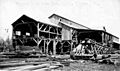
The Wagner and Wilson sawmill, one of the largest in Monroe at the beginning of the 20th century
-
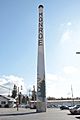
The freestanding Carnation Condensery Stack, constructed for a condensed milk plant that closed in 1928 and burned in a fire in 1944
-
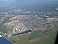
Aerial view of Monroe, looking east from Fryelands and Lake Tye
-
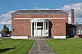
The Wagner Performing Arts Center in downtown Monroe
.jpg)

.jpg)

See also
 In Spanish: Monroe (Washington) para niños
