
Monroe County, Ohio facts for kids
Quick facts for kids
Monroe County
|
||
|---|---|---|

Monroe County Courthouse
|
||
|
||

Location within the U.S. state of Ohio
|
||
 Ohio's location within the U.S. |
||
| Country | ||
| State | ||
| Founded | March 1, 1815 | |
| Named for | James Monroe | |
| Seat | Woodsfield | |
| Largest village | Woodsfield | |
| Area | ||
| • Total | 457 sq mi (1,180 km2) | |
| • Land | 456 sq mi (1,180 km2) | |
| • Water | 1.7 sq mi (4 km2) 0.4%% | |
| Population
(2020)
|
||
| • Total | 13,385 | |
| • Density | 29.29/sq mi (11.308/km2) | |
| Time zone | UTC−5 (Eastern) | |
| • Summer (DST) | UTC−4 (EDT) | |
| Congressional district | 6th | |

Monroe County is a county located on the eastern border of the U.S. state of Ohio, across the Ohio River from West Virginia. As of the 2020 census, the population was 13,385, making it the second-least populous county in Ohio. Its county seat is Woodsfield. The county was created in 1813 and later organized in 1815.
Contents
History
Monroe County was formed on January 28, 1813 from portions of Belmont, Guernsey and Washington counties. It was named after James Monroe, the U.S. Secretary of State when the county was formed, and later fifth President of the United States.
On or about December 20, 2011, Exxon Mobil Corp., a New Jersey petroleum company, via its subsidiary XTO Energy, acquired 20,056 acres of Monroe County Utica Shale gas leases from Beck Energy.
Geography
According to the U.S. Census Bureau, the county has a total area of 457 square miles (1,180 km2), of which 456 square miles (1,180 km2) is land and 1.7 square miles (4.4 km2) (0.4%) is water.
Adjacent counties
- Belmont County (north)
- Marshall County, West Virginia (northeast)
- Wetzel County, West Virginia (east)
- Tyler County, West Virginia (southeast)
- Washington County (south)
- Noble County (west)
National protected area
- Wayne National Forest (part)
Demographics
| Historical population | |||
|---|---|---|---|
| Census | Pop. | %± | |
| 1820 | 4,645 | — | |
| 1830 | 8,768 | 88.8% | |
| 1840 | 18,521 | 111.2% | |
| 1850 | 28,351 | 53.1% | |
| 1860 | 25,741 | −9.2% | |
| 1870 | 25,779 | 0.1% | |
| 1880 | 26,496 | 2.8% | |
| 1890 | 25,175 | −5.0% | |
| 1900 | 27,031 | 7.4% | |
| 1910 | 24,244 | −10.3% | |
| 1920 | 20,660 | −14.8% | |
| 1930 | 18,426 | −10.8% | |
| 1940 | 18,641 | 1.2% | |
| 1950 | 15,362 | −17.6% | |
| 1960 | 15,268 | −0.6% | |
| 1970 | 15,739 | 3.1% | |
| 1980 | 17,382 | 10.4% | |
| 1990 | 15,497 | −10.8% | |
| 2000 | 15,180 | −2.0% | |
| 2010 | 14,642 | −3.5% | |
| 2020 | 13,385 | −8.6% | |
| U.S. Decennial Census 1790-1960 1900-1990 1990-2000 2020 |
|||
2010 census
As of the 2010 United States Census, there were 14,642 people, 6,065 households, and 4,183 families living in the county. The population density was 32.1 inhabitants per square mile (12.4/km2). There were 7,567 housing units at an average density of 16.6 per square mile (6.4/km2). The racial makeup of the county was 98.1% white, 0.4% black or African American, 0.1% Asian, 0.1% American Indian, 0.1% from other races, and 1.2% from two or more races. Those of Hispanic or Latino origin made up 0.4% of the population. In terms of ancestry, 34.8% were German, 14.5% were Irish, 10.6% were English, and 9.6% were American.
Of the 6,065 households, 27.3% had children under the age of 18 living with them, 56.0% were married couples living together, 8.6% had a female householder with no husband present, 31.0% were non-families, and 27.3% of all households were made up of individuals. The average household size was 2.39 and the average family size was 2.87. The median age was 44.7 years.
The median income for a household in the county was $37,030 and the median income for a family was $43,261. Males had a median income of $39,261 versus $24,922 for females. The per capita income for the county was $18,738. About 12.3% of families and 17.3% of the population were below the poverty line, including 26.7% of those under age 18 and 12.3% of those age 65 or over.
Communities

Villages
- Antioch
- Beallsville
- Clarington
- Graysville
- Jerusalem
- Lewisville
- Miltonsburg
- Stafford
- Wilson
- Woodsfield (county seat)
Townships
- Adams
- Benton
- Bethel
- Center
- Franklin
- Green
- Jackson
- Lee
- Malaga
- Ohio
- Perry
- Salem
- Seneca
- Summit
- Sunsbury
- Switzerland
- Washington
- Wayne
Census-designated places
Unincorporated communities
- Altitude
- Calais
- Cameron
- Fly
- Herlan
- Laings
- Malaga
- Marr
- Quarry
- Rinard Mills
- Swazey
- Sycamore Valley
Education
Monroe County contains the following schools through the Switzerland of Ohio Local School District:
- Elementary Schools
- Beallsville Elementary School in Beallsville, Ohio
- River Elementary School in Hannibal, Ohio
- Skyvue Elementary School in Graysville, Ohio
- Woodsfield Elementary School in Woodsfield, Ohio
- St. Sylvester Central in Woodsfield, Ohio
- High Schools
- Monroe Central High School in Woodsfield, Ohio
- River High School in Hannibal, Ohio
- Beallsville High School in Beallsville, Ohio
- Career Center
- Swiss Hills Career Center in Woodsfield, Ohio
Notable people
- Philip Allen, member of the Wisconsin State Assembly.
- William C. Chynoweth. member of the Illinois House of Representatives
- Sam V. Stewart, Montana Supreme Court Justice and the sixth Governor of Montana.
Images for kids
-
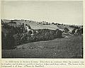
Hill farms in Monroe County, 1923
_(cropped2).jpg)
See also
 In Spanish: Condado de Monroe (Ohio) para niños
