
Monroeville, Alabama facts for kids
Quick facts for kids
Monroeville, Alabama
|
|
|---|---|
|
City
|
|
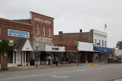
Historic buildings in Downtown Monroeville
|
|
| Nickname(s):
The Literary Capital of Alabama
|
|
| Motto(s):
"Moving the Past Forward"
|
|

Location of Monroeville in Monroe County, Alabama.
|
|
| Country | United States |
| State | Alabama |
| County | Monroe |
| Area | |
| • Total | 13.36 sq mi (34.61 km2) |
| • Land | 13.35 sq mi (34.59 km2) |
| • Water | 0.01 sq mi (0.02 km2) |
| Elevation | 413 ft (126 m) |
| Population
(2020)
|
|
| • Total | 5,951 |
| • Density | 445.63/sq mi (172.06/km2) |
| Time zone | UTC-6 (Central (CST)) |
| • Summer (DST) | UTC-5 (CDT) |
| ZIP codes |
36460–36462
|
| Area codes | 251 Exchanges: 575,743 |
| FIPS code | 01-50192 |
| GNIS feature ID | 0152359 |
Monroeville is the county seat of Monroe County, Alabama, United States. At the 2020 census its population was 5,951.
Monroeville is known as the hometown of two prominent writers of the post-World War II period, Truman Capote and Harper Lee, who were childhood friends in the 1930s. Lee's 1960 novel To Kill a Mockingbird earned her the Pulitzer Prize. The lasting fame of To Kill a Mockingbird became a tourist draw for the town. In 1997, the Alabama Legislature designated Monroeville and Monroe County as the "Literary Capital of Alabama". Monroeville is also the home of Walter McMillian, who was defended by Bryan Stevenson in overturning a wrongful conviction and featured in his memoir Just Mercy (2014), as well as the 2019 eponymous movie adaptation.
Contents
History
The town was initially known as Walker's Mill and Store, named for Major Walker, the area's first white settler. In 1832, the county seat was relocated to Monroeville from Claiborne on the Alabama River. The settlement was briefly renamed "Centerville" due to its location in the center of the county, but then it was formally changed to Monroeville. The town was not formally incorporated until April 15, 1899.
Geography
Monroeville is located at 31°31′5″N 87°19′39″W / 31.51806°N 87.32750°W (31.518075, -87.327543).
According to the U.S. Census Bureau, the city has a total area of 13.4 square miles (34.7 km2), of which 13.4 square miles (34.6 km2) is land and 0.0077 square miles (0.02 km2), or 0.05%, is water.
Demographics
| Historical population | |||
|---|---|---|---|
| Census | Pop. | %± | |
| 1880 | 122 | — | |
| 1900 | 422 | — | |
| 1910 | 616 | 46.0% | |
| 1920 | 1,017 | 65.1% | |
| 1930 | 1,355 | 33.2% | |
| 1940 | 1,724 | 27.2% | |
| 1950 | 2,772 | 60.8% | |
| 1960 | 3,632 | 31.0% | |
| 1970 | 4,846 | 33.4% | |
| 1980 | 5,674 | 17.1% | |
| 1990 | 6,993 | 23.2% | |
| 2000 | 6,862 | −1.9% | |
| 2010 | 6,519 | −5.0% | |
| 2020 | 5,951 | −8.7% | |
| U.S. Decennial Census 2013 Estimate |
|||
At the 2000 census there were 6,862 people, 2,687 households, and 1,870 families living in the city. The population density was 525.8 people per square mile (203.0/km2). There were 3,016 housing units at an average density of 231.1 per square mile (89.2/km2). The racial makeup of the city was 53.09% White, 44.84% Black or African American, 0.38% Native American, 0.58% Asian, 0.15% from other races, and 0.96% from two or more races. 0.90% of the population were Hispanic or Latino of any race. Of the 2,687 households 34.3% had children under the age of 18 living with them, 48.0% were married couples living together, 18.9% had a female householder with no husband present, and 30.4% were non-families. 28.0% of households were one person and 11.7% were one person aged 65 or older. The average household size was 2.46 and the average family size was 3.04.
The age distribution was 27.7% under the age of 18, 8.9% from 18 to 24, 24.6% from 25 to 44, 22.2% from 45 to 64, and 16.6% 65 or older. The median age was 36 years. For every 100 females, there were 82.0 males. For every 100 females age 18 and over, there were 76.4 males.
The median household income was $28,229 and the median family income was $36,476. Males had a median income of $35,600 versus $20,184 for females. The per capita income for the city was $17,070. About 20.4% of families and 23.0% of the population were below the poverty line, including 29.0% of those under age 18 and 19.2% of those age 65 or over.
2010 census
At the 2010 census there were 6,519 people, 2,656 households, and 1,723 families living in the city. The population density was 488 people per square mile (188.4/km2). There were 3,056 housing units at an average density of 228.1 per square mile (88.3/km2). The racial makeup of the city was 55.7% White, 42.1% Black or African American, 0.3% Native American, 0.3% Asian, 0.3% from other races, and 1.2% from two or more races. 0.8% of the population were Hispanic or Latino of any race. Of the 2,656 households 28.4% had children under the age of 18 living with them, 39.8% were married couples living together, 21.1% had a female householder with no husband present, and 35.1% were non-families. 30.5% of households were one person and 12.9% were one person aged 65 or older. The average household size was 2.37 and the average family size was 2.95.
The age distribution was 24.6% under the age of 18, 9.4% from 18 to 24, 21.8% from 25 to 44, 26.2% from 45 to 64, and 18.0% 65 or older. The median age was 40.2 years. For every 100 females, there were 87.7 males. For every 100 females age 18 and over, there were 88.5 males.
The median household income was $31,593 and the median family income was $49,548. Males had a median income of $41,324 versus $31,033 for females. The per capita income for the city was $20,553. About 23.3% of families and 27.7% of the population were below the poverty line, including 37.3% of those under age 18 and 19.0% of those age 65 or over today.
2020 census
| Race | Num. | Perc. |
|---|---|---|
| White | 2,146 | 36.06% |
| Black or African American | 3,530 | 59.32% |
| Native American | 25 | 0.42% |
| Asian | 46 | 0.77% |
| Other/Mixed | 142 | 2.39% |
| Hispanic or Latino | 62 | 1.04% |
As of the 2020 census, there were 5,951 people, 2,106 households, and 1,259 families residing in the city.
Education
Monroeville is home to Coastal Alabama Community College, a state-supported, fully accredited, comprehensive two-year college serving southwest Alabama. Its main campuses are in Monroeville and Thomasville.
Notable people
- Marsha Barbour, first lady of the State of Mississippi from 2004 to 2012
- Chris Booker, Major League Baseball player
- Truman Capote, author
- Mark Childress, novelist
- Marva Collins, educator
- Amasa Coleman Lee, lawyer and legislator
- Harper Lee, author of To Kill a Mockingbird and Go Set a Watchman
- Walter McMillian, exonerated and freed in 1993 after being sentenced to death in a wrongful conviction
- Allison Moorer, folk singer
- Fannie E. Motley, first African-American student to graduate from Spring Hill College
- Marie Rudisill, author and television personality
- Bill Selby, former utility player from 1996 to 2003 with the Boston Red Sox, Cincinnati Reds, and Cleveland Indians
- Cynthia Tucker, syndicated columnist who won the 2007 Pulitzer Prize for Commentary, was born here
- Redd Velvet, singer, songwriter, social activist
- Tytus Howard, current tackle for the Houston Texans
Images for kids
-
Old Monroe County Courthouse, the model for the courthouse used in the 1962 film To Kill a Mockingbird

See also
 In Spanish: Monroeville (Alabama) para niños
