
Montpelier, Vermont facts for kids
Quick facts for kids
Montpelier
|
|||
|---|---|---|---|
|
State capital and city
|
|||

|
|||
|
|||

Location in Washington County in Vermont
|
|||

Montpelier, Vermont
Location in the United States

Montpelier, Vermont
Location in Vermont
|
|||
| Country | |||
| State | |||
| County | Washington | ||
| Region | New England | ||
| Settled | 1787 | ||
| Incorporated (village) | 1818 | ||
| Incorporated (city) | 1895 | ||
| Named for | Montpellier, France | ||
| Area | |||
| • Total | 10.25 sq mi (26.54 km2) | ||
| • Land | 10.05 sq mi (26.04 km2) | ||
| • Water | 0.19 sq mi (0.50 km2) | ||
| Elevation | 525 ft (160 m) | ||
| Population
(2020)
|
|||
| • Total | 8,074 | ||
| • Density | 787.7/sq mi (304.22/km2) | ||
| Demonym(s) | Montpelierite | ||
| Time zone | UTC−5 (EST) | ||
| • Summer (DST) | UTC−4 (EDT) | ||
| ZIP codes |
05601-05604, 05609, 05620, 05633
|
||
| Area code(s) | 802 | ||
| FIPS code | 50-46000 | ||
| GNIS feature ID | 1461834 | ||
| Interstates | |||
| U.S. Highways | |||
| State Routes | |||


Montpelier is the capital city of the U.S. state of Vermont and the seat of Washington County. The site of Vermont's state government, it is the least populous state capital in the United States. As of the 2020 census, the population was 8,074. However, the daytime population grows to about 21,000, due to the large number of jobs within city limits. The Vermont College of Fine Arts is located in the municipality. It was named after Montpellier, a city in the south of France.
Contents
History

The first permanent settlement began in May 1787, when Colonel Jacob Davis and General Parley Davis arrived from Charlton, Massachusetts. General Davis surveyed the land, while Colonel Davis cleared forest and erected a large log house on the west side of the North Branch of the Winooski River. His family moved in the following winter.
Colonel Davis selected the name "Montpelier" after the French city of Montpellier. There was a general enthusiasm for things French as a result of the country's aid to the American colonies during the Revolutionary War. The settlement grew quickly, and by 1791 the population reached 117.
In 1825, the Marquis de Lafayette visited Montpelier on a triumphal tour of America, 50 years after the Revolutionary War.
The town developed into a center for manufacturing, especially after the Central Vermont Railway opened in Montpelier on June 20, 1849—the same year East Montpelier was set off as a separate town. Falls on the Winooski River provided water power for mills. There was an iron foundry.
Ten thousand people turned out to greet Major General Philip Sheridan when he visited to address the fourth annual meeting of Vermont former Union officers. He particularly thanked Vermont veterans of the Civil War for their performance at the Battle of Cedar Creek.
The town had the first municipal water driven hydro system in Vermont in 1884. Water pressure generated sufficient electricity for streetlights.
The state proclaimed October 12, 1899, as "Dewey Day" to honor native son George Dewey, the hero of Battle of Manila Bay and the Spanish–American War. Thousands turned out from the state to his hometown of Montpelier for the celebration.
Geography

Montpelier is located at 44°15′N 72°34′W / 44.250°N 72.567°W (44.2500, −72.5667) in the north-central area of Vermont. The city center is a flat clay zone (elevation 520 ft/158 m), surrounded by hills and granite ledges. Towne Hill runs in a 2-mile (3.2 km) ridge (~900 ft/275 m) along the northern edge of the city.
According to the United States Census Bureau, the city has a total area of 10.3 square miles (27 km2), of which 10.2 square miles (26 km2) is land and 0.10% is water. The Winooski River flows west along the south edge of downtown village and is fed by several smaller tributaries that cut through residential districts. Montpelier is subject to periodic flooding in the flat city center, with two major floods occurring 1927 and 1992.
On its borders are the towns of Middlesex to the west, Berlin to the south, and East Montpelier to the north and east. Montpelier lies near the geographic center of the state.
Climate
Montpelier features a humid continental climate (Köppen Dfb), with long, cold, and snowy winters, short springs and autumns, and warm summers. From January to July, daily means range from 16.4 to 67.3 °F (−8.7 to 19.6 °C). In winter, lows fall below 0 °F or −17.8 °C on 24 mornings and daytime highs stay below freezing for the majority of afternoons from December to February. Snow is also frequent and remains on the ground for long stretches throughout the winter, though thaws are by no means infrequent. Average annual snowfall is 94.2 inches or 2.39 metres. Summers are warm and often humid, with 2 or 3 days above 90 °F or 32.2 °C, but rarely reaching 95 °F or 35 °C.
Extremes have ranged from −34 °F or −36.7 °C in January 1981 to 97 °F or 36.1 °C, most recently recorded in July 1977.
| Climate data for Montpelier, Vermont | |||||||||||||
|---|---|---|---|---|---|---|---|---|---|---|---|---|---|
| Month | Jan | Feb | Mar | Apr | May | Jun | Jul | Aug | Sep | Oct | Nov | Dec | Year |
| Record high °F (°C) | 66 (19) |
61 (16) |
82 (28) |
90 (32) |
90 (32) |
95 (35) |
97 (36) |
97 (36) |
92 (33) |
84 (29) |
76 (24) |
67 (19) |
97 (36) |
| Average high °F (°C) | 26.4 (−3.1) |
30.3 (−0.9) |
39.0 (3.9) |
53.3 (11.8) |
65.7 (18.7) |
74.3 (23.5) |
78.5 (25.8) |
76.7 (24.8) |
68.7 (20.4) |
56.0 (13.3) |
43.8 (6.6) |
31.6 (−0.2) |
53.7 (12.1) |
| Average low °F (°C) | 7.0 (−13.9) |
9.5 (−12.5) |
18.9 (−7.3) |
31.5 (−0.3) |
41.9 (5.5) |
51.2 (10.7) |
55.7 (13.2) |
53.8 (12.1) |
46.1 (7.8) |
35.3 (1.8) |
26.9 (−2.8) |
14.4 (−9.8) |
32.7 (0.4) |
| Record low °F (°C) | −34 (−37) |
−29 (−34) |
−18 (−28) |
2 (−17) |
20 (−7) |
29 (−2) |
35 (2) |
31 (−1) |
20 (−7) |
14 (−10) |
−7 (−22) |
−27 (−33) |
−34 (−37) |
| Average precipitation inches (mm) | 2.45 (62) |
2.04 (52) |
2.39 (61) |
2.66 (68) |
3.37 (86) |
3.80 (97) |
4.08 (104) |
4.01 (102) |
3.12 (79) |
3.44 (87) |
3.17 (81) |
2.74 (70) |
37.27 (949) |
| Average snowfall inches (cm) | 22.6 (57) |
18.0 (46) |
16.8 (43) |
4.9 (12) |
0.0 (0.0) |
0.0 (0.0) |
0.0 (0.0) |
0.0 (0.0) |
0.0 (0.0) |
0.9 (2.3) |
9.1 (23) |
21.9 (56) |
94.2 (239) |
| Average precipitation days (≥ 0.01 in) | 13.0 | 11.2 | 11.3 | 12.6 | 12.9 | 12.4 | 12.4 | 11.7 | 10.4 | 12.3 | 14.0 | 14.4 | 148.6 |
| Average snowy days (≥ 0.1 in) | 12.0 | 9.1 | 7.5 | 3.3 | 0.0 | 0.0 | 0.0 | 0.0 | 0.0 | 0.9 | 5.7 | 11.7 | 50.2 |
| Source: NOAA (normals 1981–2010, extremes 1948–present) | |||||||||||||
Demographics
| Historical population | |||
|---|---|---|---|
| Census | Pop. | %± | |
| 1800 | 890 | — | |
| 1810 | 1,877 | 110.9% | |
| 1820 | 2,308 | 23.0% | |
| 1830 | 1,193 | −48.3% | |
| 1840 | 3,725 | 212.2% | |
| 1850 | 2,310 | −38.0% | |
| 1860 | 2,411 | 4.4% | |
| 1870 | 3,023 | 25.4% | |
| 1880 | 3,219 | 6.5% | |
| 1890 | 4,160 | 29.2% | |
| 1900 | 6,266 | 50.6% | |
| 1910 | 7,856 | 25.4% | |
| 1920 | 7,125 | −9.3% | |
| 1930 | 7,837 | 10.0% | |
| 1940 | 8,006 | 2.2% | |
| 1950 | 8,559 | 6.9% | |
| 1960 | 8,782 | 2.6% | |
| 1970 | 8,609 | −2.0% | |
| 1980 | 8,241 | −4.3% | |
| 1990 | 8,247 | 0.1% | |
| 2000 | 8,035 | −2.6% | |
| 2010 | 7,855 | −2.2% | |
| 2020 | 8,074 | 2.8% | |
| U.S. Decennial Census | |||
Along with Barre, the city forms a small micropolitan area in the center of the state; together they are known as the twin cities.
At the 2019 American Community Survey, an estimated 7,852 people lived in the city. At the census of 2010, there were 7,855 people, 3,739 households, and 1,940 families residing in the city. The population density was 784.0 people per square mile (302.7/km2). There were 3,899 housing units at an average density of 380.4 per square mile (146.9/km2).
At the 2010 census, there were 3,739 households, out of which 26.0% had children under the age of 18 years living with them, 38.5% were married couples living together, 10.1% had a female householder with no husband present, and 48.1% were non-families. 39.4% of all households were made up of individuals, and 13.1% had someone living alone who was 65 years of age or older. The average household size was 2.09 and the average family size was 2.84.
In the city, the population was spread out, with 21.3% under the age of 18, 8.6% from 18 to 24, 28.2% from 25 to 44, 27.1% from 45 to 64, and 14.9% who were 65 years of age or older. The median age was 40 years. For every 100 females, there were 84.2 males. For every 100 females age 18 and over, there were 82.0 males.
The median income for a household in the city was $37,513, and the median income for a family was $51,818. Males had a median income of $35,957 versus $29,442 for females. The per capita income for the city was $22,599. About 7.2% of families and 9.8% of the population were below the poverty line, including 12.9% of those under age 18 and 5.7% of those age 65 or over.
In 2019, there were 3,668 households with an average of 2.03 persons per household. The city had an owner-occupied housing rate of 55.6% and median value of owner-occupied housing rate of $252,600. The median monthly cost of an owner-occupied housing unit was $1,827 and without a mortgage $822. The city had a median gross rent of $1,022.
Race and ethnicity
In 2019, the racial and ethnic makeup of Montpelier was 92.2% non-Hispanic white, 1.6% Black or African American, 1.5% Asian, 2.4% two or more races, and 2.3% Hispanic or Latin American of any race. Among the population in 2019, 4.1% were foreign-born persons. In 2010, the racial makeup of the city was 93.7% White, 1.0% African American, 0.3% Native American, 2.2% Asian, 0.01% Pacific Islander, 0.39% from other races, and 2.2% from two or more races. Hispanic or Latino of any race were 2.1% of the population.
Infrastructure
Transportation

Montpelier has become one of Vermont's most readily accessible cities and towns, as Vermont's founders deliberately placed the capital near the geographic center of the state.
Roads
The city is located along Interstate 89. East–west U.S. Route 2 and north–south Vermont Route 12 are two other principal routes that intersect in Montpelier. Both I-89 and U.S. 2 provide a direct link to Burlington and the populous Lake Champlain Valley in the northwestern corner of the state. U.S. Route 302 has its western terminus in Montpelier, connecting it with the nearby city of Barre and points east.
Rail
Amtrak, the national passenger rail system, provides daily service from its station at Montpelier Junction in the neighboring town of Berlin, on the route known as the "Vermonter", operating between St. Albans, Vermont and Washington, D.C.
Bus
Greyhound and Megabus operate buses that serve Montpelier. The Green Mountain Transit Authority (GMTA) operates a local bus network throughout the micropolitan area, with stops in Montpelier and Barre, including nearby Waterbury, the Vermont State House, the Ben & Jerry's factory, and the local Berlin Mall. GMTA and its sister bus company in Burlington, the Chittenden County Transportation Authority (CCTA), operate a series of LINK commuter buses with stops in Montpelier, Burlington, Richmond, and Waterbury.
Air
Air travelers in private planes can use the Edward F. Knapp State Airport in Berlin to access Montpelier. The Burlington International Airport in Chittenden County is the closest commercial air service, located 35 miles (56 km) northwest of Montpelier.
Other
Two shared-use paths for walking and bicycling connect to Montpelier: the Cross Vermont Trail and the Central Vermont Regional Path. Montpelier's downtown is relatively compact and pedestrian-friendly, with sidewalks and crosswalks throughout the downtown area.
Arts and culture
- Kellogg-Hubbard Library—with a copy of the Parthenon Frieze
- Lost Nation Theater
- Montpelier Theatre Guild
- Vermont History Museum—in The Pavilion
- Vermont State House
- T. W. Wood Gallery & Arts Center
- Capital City Concerts
- An annual local vernacular culture phenomenon, the Valentine Phantom, a tradition of covering downtown storefronts and public buildings with red hearts each February 14, began in Montpelier in the 1990s.
Parks and natural areas
The city has three city nature centers. Hubbard Park rises behind the state capitol building and extends along the ridge line towards the north past the pool to the stump dump. Accessible from Cummings Street off State Route 12, the North Branch River Park is the second-largest park in the city. The Mill Pond Park is located along State Route 12 approximately a 0.25 miles (0.40 km) from the cemetery and features boat access to the North Branch river, as well as benches and short-term parking. The North Branch Nature Center is located at the northern end of town and includes 17 acres (6.9 ha) of protected land as well as a community nature center. A bridge from the North Branch Nature Center connects the land to the North Branch River Park on the opposite side of the North Branch River.
Economy

Government, higher education, insurance and tourism are principal businesses.
Industry
Since the city's establishment as capital in 1805, the primary business in Montpelier has been government, and by the mid-19th century government and life and fire insurance. Companies based in Montpelier include the National Life Group.
Located in Montpelier are the New England Culinary Institute, the annual Green Mountain Film Festival and the headquarters of several insurance companies. The majority of businesses in the downtown area, mostly retail, are locally owned.
Montpelier is the only state capital in the United States of America that does not have a McDonald's. However, there is a McDonald's location in nearby Berlin, Vermont.
Tourism
The Vermont History Museum, operated in The Pavilion by the Vermont Historical Society, is an attraction.
Sports
The Vermont Mountaineers of the New England Collegiate Baseball League play at the Montpelier Recreation Field.
Education
- Public schools include:
- Montpelier High School
- Main Street Middle School
- Union Elementary School
- River Rock School is a private school serving kindergarten through 8th grade students.
- A campus of the Community College of Vermont
- New England Culinary Institute, a for-profit career college
- Union Institute & University Vermont campus, offers a Master of Education program through a low-residency (online) program
- Vermont College of Fine Arts is a low-residency graduate school offering Masters of Fine Arts degrees in visual arts, writing, and writing for children and young adults
Notable people
Images for kids
-
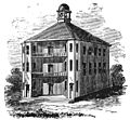
The first Vermont State House, built in 1808, was designed by Sylvanus Baldwin.
-
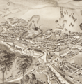
Montpelier as illustrated in 1884
-
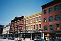
State Street, Montpelier Historic District, 2006
-
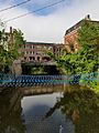
Building of the State street built on the North Branch River (tributary of Winooski River).
-
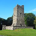
Hubbard Park Observation Tower, built 1915–1930
.jpg)


See also
 In Spanish: Montpelier (Vermont) para niños
