
Mooresville, Alabama facts for kids
Quick facts for kids
Mooresville, Alabama
|
|
|---|---|

Mooresville Post Office
|
|

Location of Mooresville in Limestone County, Alabama.
|
|
| Country | United States |
| State | Alabama |
| County | Limestone |
| Town of Mooresville | November 16, 1818 |
| Area | |
| • Total | 0.30 sq mi (0.77 km2) |
| • Land | 0.25 sq mi (0.65 km2) |
| • Water | 0.05 sq mi (0.13 km2) |
| Elevation | 574 ft (175 m) |
| Population
(2020)
|
|
| • Total | 47 |
| • Density | 188.00/sq mi (72.72/km2) |
| Time zone | UTC-6 (Central (CST)) |
| • Summer (DST) | UTC-5 (CDT) |
| ZIP code |
35649
|
| Area code(s) | 256 |
| FIPS code | 01-51264 |
| GNIS feature ID | 0123033 |
Mooresville is a town in Limestone County, Alabama, United States, located southeast of the intersection of Interstate 565 and Interstate 65, and north of Wheeler Lake.
The town is between Huntsville and Decatur, and is part of the Huntsville-Decatur Combined Statistical Area; its population as of the 2010 census is 53, down from 59 in 2000.
Although the town's per-capita income is over $50,000, Mooresville is within the area covered by the charter for the Appalachian Regional Commission, an organization whose goal is to help increase the per-capita income of impoverished areas. Mooresville is within Corridor V of the Appalachian Development Highway System.
The town was the primary filming location for Disney's live action production of Tom and Huck (1995).
History
Mooresville is one of the oldest incorporated towns in Alabama, having been incorporated on November 16, 1818, when Alabama was still a Territory. The entire town, described as a picturesque early 19th century village, is listed on the National Register of Historic Places. The 1840 post office is the oldest in operation in Alabama and has call boxes dating before the American Civil War. Andrew Johnson, later to become to 17th president of the United States, lived in Mooresville as an apprentice tailor when he was a young man. The Union Army occupied Mooresville several times during the Civil War, and a few skirmishes were fought in the vicinity.
Geography
Mooresville is located at 34°37′37″N 86°52′52″W / 34.62694°N 86.88111°W (34.626931, -86.881091).
According to the U.S. Census Bureau, the town has a total area of 0.1 square miles (0.26 km2), all land.
Demographics
| Historical population | |||
|---|---|---|---|
| Census | Pop. | %± | |
| 1870 | 165 | — | |
| 1880 | 183 | 10.9% | |
| 1890 | 143 | −21.9% | |
| 1900 | 150 | 4.9% | |
| 1910 | 137 | −8.7% | |
| 1920 | 144 | 5.1% | |
| 1930 | 114 | −20.8% | |
| 1940 | 129 | 13.2% | |
| 1950 | 101 | −21.7% | |
| 1960 | 93 | −7.9% | |
| 1970 | 72 | −22.6% | |
| 1980 | 58 | −19.4% | |
| 1990 | 54 | −6.9% | |
| 2000 | 59 | 9.3% | |
| 2010 | 53 | −10.2% | |
| 2020 | 47 | −11.3% | |
| U.S. Decennial Census | |||
As of the census of 2000, 59 people, 24 households, and 19 families resided in the town. The population density was 741.1 people per square mile (284.8/km2). There were 28 housing units at an average density of 351.7 per square mile (135.1/km2). The racial makeup was 88.14% White and 11.86% Black or African American.
There were 24 households, of which 25.0% had children under 18 living with them; 66.7% were married couples living together; 12.5% had a female householder with no husband present; and 20.8% were non-families. 20.8% of all households were made up of individuals, and 12.5% had someone living alone who was 65 years of age or older. The average household size was 2.46 and the average family size was 2.84.
In the town, the population was spread out, with 16.9% under the age of 18, 6.8% from 18 to 24, 20.3% from 25 to 44, 40.7% from 45 to 64, and 15.3% who were 65 years of age or older. The median age was 50 years. For every 100 females, there were 118.5 males. For every 100 females age 18 and over, there were 104.2 males.
The median income for a household in the town was $54,167, and the median income for a family was $136,039. Males had a median income of $51,667 versus $65,417 for females. The per capita income for the town was $51,694, unusually high for the state. No families and 4.3% of the population are living below the poverty line, including 3.33% of those over 64.
Gallery
-
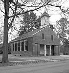
Old Brick Church in Mooresville
-
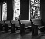
Pews in Old Brick Church


Notable people
- Wade Keyes, Confederate States Attorney General in 1861, and from 1863 to 1864
- James Sloss, planter, industrialist, and founder of Sloss Furnaces
Images for kids
-
Mooresville, Alabama

See also
 In Spanish: Mooresville (Alabama) para niños
