
Morella, Queensland facts for kids
Quick facts for kids MorellaQueensland |
|||||||||||||||
|---|---|---|---|---|---|---|---|---|---|---|---|---|---|---|---|

Landscape, 2019
|
|||||||||||||||

Morella
Location in Queensland
|
|||||||||||||||
| Population | 33 (2016 census) | ||||||||||||||
| Postcode(s) | 4730 | ||||||||||||||
| Time zone | AEST (UTC+10:00) | ||||||||||||||
| Location |
|
||||||||||||||
| LGA(s) | Longreach Region | ||||||||||||||
| State electorate(s) | Gregory | ||||||||||||||
| Federal Division(s) | Maranoa | ||||||||||||||
|
|||||||||||||||
Morella was a rural locality within Longreach Region, Queensland, Australia. Since January 2019, it has been amalgamated into the locality of Longreach.
Contents
Geography
The Landsborough Highway passes from south-east to north-west through the locality.
History
Morella Post Office opened on 1 July 1927 and closed in 1979.
Heritage listings
Morella has a number of heritage-listed sites, including:
- Landsborough Highway: Darr River Downs
Images for kids
-
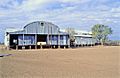
Darr River Downs woolshed, 1998
-
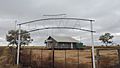
Queensland Country Women's Association hall, Morella, 2019
.jpg)


All content from Kiddle encyclopedia articles (including the article images and facts) can be freely used under Attribution-ShareAlike license, unless stated otherwise. Cite this article:
Morella, Queensland Facts for Kids. Kiddle Encyclopedia.