
Morpeth, New South Wales facts for kids
Quick facts for kids MorpethMaitland, New South Wales |
|||||||||||||||
|---|---|---|---|---|---|---|---|---|---|---|---|---|---|---|---|
St_Johns_College_Morpeth-1.jpg)
Closebourne (formerly St John's Theological College)
|
|||||||||||||||

Morpeth
Location in New South Wales
|
|||||||||||||||
| Population | 1,403 (2016 census) | ||||||||||||||
| • Density | 188/km2 (490/sq mi) | ||||||||||||||
| Established | 1821 | ||||||||||||||
| Postcode(s) | 2321 | ||||||||||||||
| Elevation | 15 m (49 ft) | ||||||||||||||
| Area | 4.8 km2 (1.9 sq mi) | ||||||||||||||
| Time zone | AEST (UTC+10) | ||||||||||||||
| • Summer (DST) | AEDT (UTC+11) | ||||||||||||||
| Location | |||||||||||||||
| LGA(s) | City of Maitland | ||||||||||||||
| Region | Hunter | ||||||||||||||
| County | Northumberland | ||||||||||||||
| Parish | Alnwick | ||||||||||||||
| State electorate(s) | Maitland | ||||||||||||||
| Federal Division(s) | Paterson | ||||||||||||||
|
|||||||||||||||
Morpeth is a suburb of the city of Maitland in the Hunter Region of New South Wales, Australia. It is on the southern banks of the Hunter River at the border between the City of Maitland and Port Stephens Council LGAs. The major population centre, where almost all residents of the suburb reside, is the historical town of Morpeth which takes its name from Morpeth, Northumberland, near Newcastle upon Tyne, in England.
History
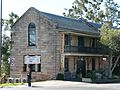
The town of Morpeth was initially created through the private actions of Lieutenant E.C.Close, who selected a property of 1,000 hectares and developed it as a river port from 1831-1841. The lieutenant built his house, known as Closebourne, on the property. A two-storey Georgian home made of sandstone, the house became an episcopal residence from 1848-1912, which eventually became the nucleus of St John's Theological College on Morpeth Road.
The river port grew steadily throughout the 1830s; St James's Church, Tank Street, was built from 1837 to 1840. It was partly designed by John Horbury Hunt and now has a Local Government Heritage listing. A major merchant at this time was James Taylor, who built a bond store circa 1850, located near the bridge and now heritage-listed. The town continued to expand. Morpeth Court House was built circa 1861 in a Greek Revival style; the police station followed in 1879. The construction of the Great Northern Railway in 1857, bypassing Morpeth, meant that Newcastle developed as the regional port. Morpeth became less significant commercially, but still survived as a township with its own history and heritage.
The town today is a tourist destination due to its many historical buildings and river bank setting. The following buildings are listed on the Register of the National Estate:
- Closebourne, Morpeth Road
- Former Bond Stores, Swan Street
- Morpeth Bridge
- Morpeth Public Library (formerly Court House),Swan Street
- Police Station, High and George Streets
- Former Morpeth Railway Station
Gallery
-
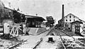
Morpeth Station, 1954
-
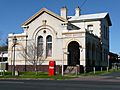
Morpeth Post Office, Swan Street
-
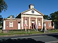
Old Court House, Swan Street
-
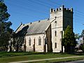
St James's Church (1840), Tank Street
-
Morpeth Bond Stores, Swan Street


- The Australian Bureau of Statistics Census Collection District of Morpeth only includes the township. It excludes persons living on rural properties close to the township in the remainder of the suburb. This means that the actual population of Morpeth is slightly higher than shown.
- Average elevation of the suburb as shown on 1:100000 map 9232 NEWCASTLE.
- Area calculation is based on 1:100000 map 9232 NEWCASTLE.
Images for kids
-
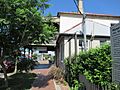
Arnott Bakehouse, Swan Street
-
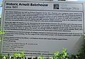
Arnott Bakehouse Plaque


