
Mount Alford, Queensland facts for kids
Quick facts for kids Mount AlfordQueensland |
|||||||||||||||
|---|---|---|---|---|---|---|---|---|---|---|---|---|---|---|---|

Paddocks to the north east of Mount Moon
|
|||||||||||||||

Mount Alford
Location in Queensland
|
|||||||||||||||
| Population | 268 (2016 census locality) | ||||||||||||||
| • Density | 6.683/km2 (17.31/sq mi) | ||||||||||||||
| Postcode(s) | 4310 | ||||||||||||||
| Elevation | 120 m (394 ft) | ||||||||||||||
| Area | 40.1 km2 (15.5 sq mi) | ||||||||||||||
| Time zone | AEST (UTC+10:00) | ||||||||||||||
| Location |
|
||||||||||||||
| LGA(s) | Scenic Rim Region | ||||||||||||||
| State electorate(s) | Scenic Rim | ||||||||||||||
| Federal Division(s) | Wright | ||||||||||||||
|
|||||||||||||||
Mount Alford is a rural town and locality in the Scenic Rim Region, Queensland, Australia. In the 2016 census the locality of Mount Alford had a population of 268 people.
Geography
Teviot Brook passes just to the east of the town. Downstream is the Wyaralong Dam. Erosion along Blackrock Creek has prompted the Scenic Rim Regional Council and SEQ Catchments to implement on-farm infrastructure and land management practice changes to reduce sediment runoff and improve water quality. In the south west of the locality the land slopes upwards towards Mount Moon.
History
Mount Alford was previously known as Reckumpilla. It was renamed after Thomas Alford who managed Coochin Coochin station from 1868 onwards. A general store opened in the town in c1888 by August Anders. The building was rebuilt in 1913 upon sale by the Anders family. Mount Alford Primary school was built in 1888. A monument to those who served and who were killed in World War I was erected in 1918.
Heritage listings
Mount Alford has the following heritage-listed sites:
- 889 Reckumpilla Street: Mount Alford School of Arts
- 898 Reckumpilla Street: Mount Alford General Store
Gallery
-
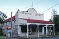
Mount Alford General Store
-
Mount Alford School of Arts established 1906


Demographics
Mount Alford has a population of 268 at the 2016 census. The locality contains 123 households, in which 47.5% of the population are males and 52.5% of the population are females with a median age of 53, 15 years above the national average. The average weekly household income is $1,218, $220 below the national average.
3.0% of Mount Alford's population is either of Aboriginal or Torres Strait Islander descent. 75.6% of the population aged 15 or over is either registered or de facto married, while 24.4% of the population is not married. 21.3% of the population is currently attending some form of a compulsory education. The most common nominated ancestries were English (32.1%), Australian (27.1%) and German (15.6%), while the most common country of birth was Australia (88.3%), and the most commonly spoken language at home was English (94.4%). The most common nominated religions were No religion (32.9%), Anglican (20.8%) and Catholic (12.5%). The most common occupation was a labourer (21.9%) and the majority/plurality of residents worked 40 or more hours per week (36.4%).
Education
Mount Alford State School is a government primary (Prep-6) school for boys and girls at 942 Reckumpilla Street (28°04′06″S 152°35′41″E / 28.0682°S 152.5947°E). In 2018, the school had an enrolment of 62 students with 9 teachers (4 full-time equivalent) and 11 non-teaching staff (5 full-time equivalent).
There is no secondary school in Mount Alford. The nearest secondary school is Boonah State High School in Boonah to the north-east.
Images for kids
-
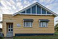
Former St John's Lutheran Church, Mount Alford, 2005

