
Mount Arvon facts for kids
Quick facts for kids Mount Arvon |
|
|---|---|

Mount Arvon summit sign and log book
|
|
| Highest point | |
| Elevation | 1,979 ft (603 m) NGVD 29 |
| Prominence | 948 ft (289 m) |
| Listing | U.S. state high point 38th |
| Geography | |

Mount Arvon
Location in Michigan
|
|
| Parent range | Huron Mountains |
| Topo map | USGS Skanee South |
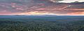
Mount Arvon, elevation 1,979 feet (603 m), located in L'Anse Township, Baraga County, is the highest natural point in the U.S. state of Michigan. Mount Arvon is part of the Huron Mountains. It rises about eight miles (13 km) south of Lake Superior (elevation 591 feet [180 m]). On the list of highest natural points in each U.S. state, Mount Arvon ranks 38th.

Mount Arvon is a few miles from Mount Curwood, which for years had been designated as Michigan's highest spot until a resurvey in 1982 with modern technology determined that Mount Arvon is 1 foot (0.30 m) taller than Mount Curwood. Mount Arvon is about 12 miles (19 km) east of L'Anse, although it is about a 26-mile (42 km) drive from the city as much of it lies on winding logging roads.

View from Mount Arvon to Lake Superior, May 2014
|
The property is owned by the MeadWestvaco paper company but public access is allowed.
Images for kids
-
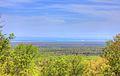
Mount Arvon viewed from the north.
-
View from Mount Arvon to Lake Superior, May 2014.
