
Mount Bachelor facts for kids
Quick facts for kids Mount Bachelor |
|
|---|---|

Mount Bachelor from Little Lava Lake
|
|
| Highest point | |
| Elevation | 9,068 ft (2,764 m) NAVD 88 |
| Geography | |
| Location | Deschutes County, Oregon, U.S. |
| Parent range | Cascade Range |
| Topo map | USGS Mount Bachelor |
| Geology | |
| Age of rock | less than 15,000 years |
| Mountain type | Stratovolcano (on top of a shield volcano) |
| Volcanic arc | Cascade Volcanic Arc |
| Last eruption | 5800 BC |
| Climbing | |
| Easiest route | Ski lifts |
Mount Bachelor, formerly named Bachelor Butte, is a dormant stratovolcano atop a shield volcano in the Cascade Volcanic Arc and the Cascade Range of central Oregon. Named Mount Bachelor because it stands apart from the nearby Three Sisters, it lies in the eastern segment of the central portion of the High Cascades, the eastern segment of the Cascade Range. The volcano lies at the northern end of the 15-mile (24 km) long Mount Bachelor Volcanic Chain, which underwent four major eruptive episodes during the Pleistocene and the Holocene. The United States Geological Survey considers Mount Bachelor a moderate threat, but Bachelor poses little threat of becoming an active volcano in the near future. It remains unclear whether the volcano is extinct or just inactive.
The Mount Bachelor ski area has operated on the mountain since 1958, and the volcano's summit hosts the Mount Bachelor Observatory. A center of winter recreation, the area offers snowshoeing, snow skiing, snow tubing, and dog sledding, among other activities. The summit can be reached by a climbing trail that travels over lava from the volcano.
Geology
Mount Bachelor was formed between 15,000 and 11,000 years ago as a shield volcano but was later capped with a stratovolcano as the eruptions apparently became more explosive over time. It is the youngest prominent volcano in the Three Sisters area of Oregon. Bachelor is composed mainly of basalt and basaltic andesite.
It last erupted between 10,000 and 8,000 years ago and is entirely covered with Mazama Ash from the catastrophic eruption of Mount Mazama about 6,845 years ago. There is no geothermal activity at present, though some areas popularly thought to be fumaroles are caused by air movement through the porous structure. Several are near the top of the Pine Marten chairlift and occasionally present a hazard to skiers and snowboarders where the snow is undermined.
Mount Bachelor Volcanic Chain
The Mount Bachelor volcanic chain, southeast of South Sister, consists of Mount Bachelor itself and a series of cinder cones, lava flows and three shield volcanoes. The northernmost shield is capped by a steep-sided summit cone of Mount Bachelor. Minor explosive activity built the many cinder cones which fed the many lava flows that account for the bulk of the erupted material.
Eruptive activity of the chain can be considered in four major episodes:
- The oldest episode occurred approximately 18,000 - 15,000 years ago during glacial retreat. Most activity during this episode was located in the central part of the chain and built a shield volcano called Sheridan Mountain. In an area near Sparks Lake a group of vents formed beneath glacial ice and interacted with the ice to form hyaloclastite deposits and thick lava flows impounded by glacial ice. The resulting steep sided plateau is capped by Talapus and Katsuk Buttes.
- During the second episode, eruptive activity was along the chain of scoria cones and lava flows that extends from the south side of Sheridan Mountain to the explosion crater at the south end of the chain.
- During the third episode of eruptive activity built the shield volcano of which is capped by Kwohl Butte and the shield that underlies Mount Bachelor. The final phase of this episode built the summit cone of Mount Bachelor. The oldest glacial moraines recognized on Mount Bachelor are approximately 12,000 years old so the cone had nearly attained its present size by then. These moraines are overlain by the youngest lava flows of the third episode.
- The last eruptive episode occurred approximately 8,000 to 10,000 years ago and produced a scoria cone and lava flows on the lower north flank of Mount Bachelor. All activity ended before 6,845 C-14 years BP, since tephra from the climactic eruption of Mount Mazama is found on all deposits of the Bachelor chain.
Skiing

Mount Bachelor ski area operates a chairlift during the summer as well as during the ski season (weather permitting). The resort is one of the largest in the Pacific Northwest with a skiable area of 3,683 acres (14.9 km2) and a vertical drop of 3,365 feet (1,026 m).
Name
Mount Bachelor is so called because it "stands apart" from the Three Sisters, a group of three volcanic mountains that are northwest of Mount Bachelor. In early days Bachelor Butte was frequently called "Brother Jonathan", or "Mount Brother", but like the names of the Three Sisters, "Johnathan" and "Brother" fell out of use. The resort developers were concerned that skiing on a butte might be perceived by consumers as "small-time" and so named their resort Mount Bachelor. Over time the popularity of the ski area led to the name Mount Bachelor coming into popular usage and in a divided decision, the Oregon Geographic Names Board voted to change the name from Bachelor Butte to Mount Bachelor.
Images for kids
-
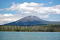
Mount Bachelor from Little Lava Lake (southwest of the mountain)
-
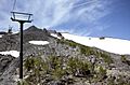
The chair lift to Mount Bachelor's summit, as seen in 1986

