
Mount Barker, Western Australia facts for kids
Quick facts for kids Mount BarkerWestern Australia |
|||||||||
|---|---|---|---|---|---|---|---|---|---|
.jpg)
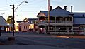
Lowood Road, Mount Barker, 2018
|
|||||||||

Mount Barker
Location in Western Australia
|
|||||||||
| Population | 1,905 (2016 census) | ||||||||
| Established | 1892 | ||||||||
| Postcode(s) | 6324 | ||||||||
| Elevation | 300 m (984 ft) | ||||||||
| Location | |||||||||
| LGA(s) | Shire of Plantagenet | ||||||||
| State electorate(s) | Warren-Blackwood | ||||||||
| Federal Division(s) | O'Connor | ||||||||
|
|||||||||
Mount Barker is a town on the Albany Highway and is the administrative centre of the Shire of Plantagenet in the Great Southern region of Western Australia. At the 2016 census, Mount Barker had a population of 1,905.
The town was named after the nearby hill, which in turn was named in 1829 by Thomas Braidwood Wilson in honour of Captain Collet Barker, who was in command of Western Australia's original British settlement at King George's Sound from 1829 to 1831.
Location
Mount Barker is situated on Albany Highway 363 kilometres (226 mi) south-east of Perth and 50 kilometres (31 mi) north of the city of Albany. The coastal town of Denmark is around 55 kilometres (34 mi) by road to the south-west via the Denmark Mount Barker Road (locally referred to as "Denbarker Road"). The timber town of Manjimup is 160 kilometres (99 mi) west of Mount Barker, via Muir Highway. The Hay River, which flows into Wilson Inlet at Denmark, begins its journey just west of Mount Barker.
History
Prior to European settlement, small groups of Aboriginal people, called the Bibbulmun (a clan of the Noongar) People, inhabited the area. These were a nomadic people who followed seasonal food supplies. The Aboriginal name for Mount Barker Hill is 'Pwakkenbak'.
In December 1829, Mount Barker was named after Captain Collet Barker, commandant of the garrison at King George Sound, by naval ship's surgeon Thomas Braidwood Wilson. Wilson explored the area in company with the Noongar Mokare from King George Sound, John Kent (officer in charge of the Commissariat at Frederick Town, King George Sound), two convicts and Private William Gough of the 39th Regiment, while his ship the Governor Phillip was being repaired.
European settlement of the Hay River area commenced around the 1830s and the opening of the Perth/Albany Railway in 1889 helped to ensure the town's future; the first store opened in 1890. Population growth continued through the 1890s and the first school and the town hall were opened in 1893. The population of the town was 326 (183 males and 143 females) in 1898.
Features

Mount Barker Hill, just 5 km from the town centre, reaches 404 metres above sea level. A sealed road leads to the base of a 184 metre high TV tower - the tallest free-standing tower in the southern hemisphere - on the summit of the hill. An information sign at the summit states that the steel TV tower weighs 340 tonnes. There is also a lookout and a granite cairn with a bronze directional plate. Views extend north to the Stirling Range and east to the Porongurup Range. An elevated concrete lookout offers views South to Albany and south-west toward Denmark. On a clear day, the Albany Wind Farm is easily visible some 50 km away. In the summer months, many locals use the hill lookout to assess any risk posed by nearby fires.

Mount Barker is also home to numerous historic buildings:
- The old police station, opened in 1868, is now a museum.
- St Werburghs Chapel was built in 1872 with walls made from chopped straw and clay and woodwork formed from local jarrah. A small cemetery doubles as a historical reference for the region. The chapel is now a tourist drawcard and still operates a regular service.
- The Mount Barker Post Office and Telegraph Station, built in 1892, ceased operation in the 1960s. Today it is named 'Mitchell House' and houses the local art society and gallery.
- Plantagenet Hotel was built between 1912 and 1914. The verandah includes apple motifs, in celebration of the flourishing apple industry. The hotel is still open for business.
- The town railway building, built in 1923, was restored in 1997 and today houses the Mount Barker Visitor Centre that offers local tourism information. The Visitor Centre no longer takes Bus bookings but these are now available from Duffy's Access Videos in Langton Rd.

- Sometime from the late 1950s to the early 1960s, Dutch immigrant and engineer Hubertus Johannes Van der Kolk built a circular house at the northern end of Mount Barker, beside Albany Highway. This unique structure, which could be rotated through 180 degrees to exploit seasonal changes, was labelled "The Round House". Though the home has fallen into disrepair, it was heritage listed in 2005 and Heritage Minister Francis Logan said "It was an energy-efficient concept ahead of its time." The home was hidden from passers-by for many years by trees and shrubs but clearing for major roadworks which commenced in December 2006 resulted in it once again being exposed to public view. Restoration works have now commenced on "The Round House" however engineers have stated that the damage is too extensive to the turning mechanism and the building will not be able to turn. The Heritage Council has published a detailed history of this "rare" building in a Register of Heritage Places - Assessment Document.
- The farming areas surrounding the town are also rich with old farmhouses, sheds and machinery.
The Stirling Range lies approximately 40 km to the north-east of the town by road, via Kendenup. The Porongurup Range is a 15-minute drive to the east of the town. The two ranges have vastly different appearances and display different flora and geology. Both parks have gazetted walk trails that are especially popular during the spring wildflower season, from August to November. The Porongurup Range has a new "Granite Skywalk" which rewards hikers taking the Castle Rock walk trail. The upper Skywalk encompasses nearly 360 degree views, whilst the lower skywalk gives visitors views across the valley to the Stirling Range.
Facilities

Mount Barker has a hospital and medical centre, police station, TAFE College, a community college catering for K-12 schooling, childcare facilities plus Scouts and Girl Guides. The new shire offices were opened in the town centre in 2006.
In 2004, the state government announced preliminary funding for construction of the Mount Barker Community College. This 'One Community, One College' project will ultimately see all public schooling, from kindergarten to TAFE, located on the existing Mount Barker Senior High School site. Work commenced on the integrated facility in January 2007 with the aim of catering for years 4 to 12 by 2008. In December 2007, funding for Stage Two, for Kindergarten to year 3, was confirmed. Construction of all stages is now complete, as is the new Trade Training Centre.
Mount Barker has commercial, retail and industrial facilities associated with the regional centre for the Plantagenet Shire. Sporting facilities include a football ground (Sounness Park), the home of the Mount Barker Football Club, a modern indoor recreation centre and gymnasium, a 50m outdoor swimming pool, speedway track, horse-racing track (Frost Park) and skate park. Popular sports include Australian Rules Football, rugby union, cricket and equestrian pursuits.
Besides the public library, Mount Barker also has cultural facilities including a public art gallery that displays and offers works by local artists. There is also a popular amateur theatre company, "The Plantagenet Players", which has members from nine years old to seniors.
Emergency services in the town consist of Police and volunteers in the St John Ambulance, Fire & Rescue Service, Bush Fire Service and State Emergency Service. Training and equipment is provided by both the Shire and State Government. There are a number of charitable organisations including Rotary, Lions, Red Cross, and Anglicare.
The Great Southern Railway, which runs through town, commenced operation to Mount Barker in 1889, boosting expansion in the region. There are no longer passenger services on the line which is used primarily for grain haulage to Albany Port.
Pardelup Prison is located near Denbarker, just west of Mount Barker.
Residents of Mount Barker, Western Australia comment that the town is often confused with Mount Barker, South Australia, especially when dealing with national telephone centres based outside Western Australia.
Climate

Mount Barker has a temperate climate with warm summers and mild to cold winters. Summer temperatures can exceed 40 degrees Celsius, but rarely do, averaging around 26 degrees. Overnight temperatures in winter can drop to 0 degrees, but rarely any lower and daytime winter temperatures average around 10-15 degrees Celsius.
Rainfall averages from around 24 millimetres (1 in) per month in January to over 100 millimetres (4 in) in July.
| Climate data for Mount Barker (1886-2013) | |||||||||||||
|---|---|---|---|---|---|---|---|---|---|---|---|---|---|
| Month | Jan | Feb | Mar | Apr | May | Jun | Jul | Aug | Sep | Oct | Nov | Dec | Year |
| Record high °C (°F) | 43.9 (111.0) |
43.6 (110.5) |
40.6 (105.1) |
37.2 (99.0) |
32.2 (90.0) |
24.3 (75.7) |
22.2 (72.0) |
25.0 (77.0) |
29.3 (84.7) |
35.6 (96.1) |
39.4 (102.9) |
42.9 (109.2) |
43.9 (111.0) |
| Average high °C (°F) | 26.2 (79.2) |
26.0 (78.8) |
24.2 (75.6) |
21.2 (70.2) |
17.8 (64.0) |
15.3 (59.5) |
14.3 (57.7) |
15.0 (59.0) |
16.8 (62.2) |
18.8 (65.8) |
21.8 (71.2) |
24.2 (75.6) |
20.1 (68.2) |
| Average low °C (°F) | 12.8 (55.0) |
13.1 (55.6) |
12.4 (54.3) |
10.7 (51.3) |
8.8 (47.8) |
7.1 (44.8) |
6.1 (43.0) |
6.1 (43.0) |
6.9 (44.4) |
8.0 (46.4) |
9.9 (49.8) |
11.4 (52.5) |
9.4 (48.9) |
| Record low °C (°F) | 1.7 (35.1) |
4.0 (39.2) |
3.6 (38.5) |
2.2 (36.0) |
0.6 (33.1) |
−1.1 (30.0) |
−2.2 (28.0) |
−1.3 (29.7) |
−0.6 (30.9) |
0.1 (32.2) |
1.1 (34.0) |
1.1 (34.0) |
−2.2 (28.0) |
| Average rainfall mm (inches) | 23.3 (0.92) |
23.9 (0.94) |
36.4 (1.43) |
54.2 (2.13) |
82.7 (3.26) |
95.3 (3.75) |
103.4 (4.07) |
89.0 (3.50) |
79.2 (3.12) |
68.6 (2.70) |
43.0 (1.69) |
29.5 (1.16) |
728.5 (28.67) |
| Average rainy days (≥ 0.2mm) | 7.7 | 7.3 | 9.8 | 12.5 | 16.3 | 18.8 | 20.3 | 19.7 | 17.5 | 15.6 | 11.2 | 9.1 | 165.8 |
| Source: Bureau of Meteorology | |||||||||||||
Significant weather events
- While light snowfalls are not unusual on the peaks of the Porongurup and Stirling Range, it is very unusual for snow to fall to ground level anywhere in Western Australia. However, snow has been recorded in Mount Barker on several occasions. On 28 August 1992, with a maximum temperature of 7.2 degrees Celsius, two falls of snow were recorded. That same year, on 19 November, a light snowfall was recorded just two weeks before summer, this was the latest in the year snow had been recorded in the whole of Western Australia.
- In June 2000, the Town Hall in Mount Barker lost its roof as a result of strong wind gusts.
- On 28 December 2000, unusually hot weather and 44 km/h winds contributed to a bushfire that travelled south through the town, destroying two houses plus other buildings and equipment.
- On 1 April 2005, the Plantagenet Shire suffered substantial flooding after heavy and persistent rainfall in the previous two days.
- Golf ball-sized hail fell in Mount Barker and surrounding districts on 23 October 2006.
Images for kids
-
Plantagenet Hotel, Lowood Road

