Mount Chiquita facts for kids
Quick facts for kids Mount Chiquita |
|
|---|---|

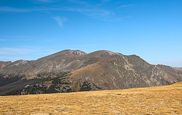
Mounts Ypsilon (left of center), Chiquita (center), and Chapin (right)
|
|
| Highest point | |
| Elevation | 13,075 ft (3,985 m) |
| Prominence | 283 ft (86 m) |
| Isolation | 0.99 mi (1.59 km) |
| Geography | |
| Location | Rocky Mountain National Park, Larimer County, Colorado, U.S. |
| Parent range | Mummy Range |
| Topo map | USGS 7.5' topographic map Trail Ridge, Colorado |
Mount Chiquita is a mountain summit in the Mummy Range of the Rocky Mountains of North America. The 13,075-foot (3,985 m) thirteener is located in Rocky Mountain National Park, 9.8 miles (15.7 km) northwest by west (bearing 298°) of the Town of Estes Park in Larimer County, Colorado, United States.
Tourists can reach Mount Chiquita via Chapin Pass which is an 8.0 kilometer out and back trail located near Estes Park, Colorado that features beautiful wild flowers and is rated as moderate. The trail is primarily used for hiking and running and is accessible year-round.

All content from Kiddle encyclopedia articles (including the article images and facts) can be freely used under Attribution-ShareAlike license, unless stated otherwise. Cite this article:
Mount Chiquita Facts for Kids. Kiddle Encyclopedia.


