
Mount Nebo (Utah) facts for kids
Quick facts for kids Mount Nebo |
|
|---|---|

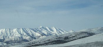
Mount Nebo, February 2005
|
|
| Highest point | |
| Elevation | 11,933 ft (3,637 m) NAVD 88 |
| Prominence | 5,488 ft (1,673 m) |
| Isolation | 75.57 mi (121.62 km) |
| Listing |
|
| Geography | |

Mount Nebo
Location in Utah
|
|
| Location | Juab / Utah counties, Utah, U.S. |
| Parent range | Wasatch Range |
| Topo map | USGS Mona |
| Climbing | |
| First ascent | 1869 |
| Easiest route | Hike |
Mount Nebo is the southernmost and highest mountain in the Wasatch Range of Utah, in the United States. Named after the biblical Mount Nebo overlooking Israel, which is said to be the place of Moses' death, it is the centerpiece of the Mount Nebo Wilderness, inside the Uinta National Forest.
Mount Nebo has two summits: the northern summit reaches 11,933 feet (3,637 m)NAVD 88, and the southern summit reaches 11,882 feet (3,622 m)NAVD 88. Early surveys placed the southern peak as the highest, but the mountain was resurveyed in the 1970s and the northern peak was found to be higher. It is the county high point of Utah County.
Mount Nebo is an "ultra", one of 128 ultra-prominent peaks in the United States having more than 1,500 metres (4,900 ft) of topographic prominence. The mountain is typically partially or completely covered in snow from mid-October until July. Nearby towns include Payson, Nephi, and Provo.
A substantial trail leads to the south summit, accessible from starting points on the east or west of the mountain. Another trail accesses the north summit, starting northeast of the mountain. A "bench trail" runs along the east side of the mountain from north to south at roughly 9,000 feet elevation. All of these trails are popular with hikers, though strenuous; many are dangerous places for horseback riders. One old-time local rider warns: "There's dead horses in every canyon on that mountain!"
The Mount Nebo Scenic Byway is a federally designated National Scenic Byway which departs I-15 at Payson and travels south through the Mount Nebo Wilderness, climbing to over 9,000 feet before rejoining the interstate at Nephi. The route features panoramic views of Mount Nebo, the Utah Valley, and Utah Lake far below. There are numerous trailheads along the route for the hiking enthusiast, including a short walk to the "Devil's Kitchen", an area which has been described as a "mini Bryce Canyon".
-

Mount Nebo (left of center) aerial view from the south, with Utah Lake and the rest of the Wasatch Range in the background and the Great Salt Lake on the far left horizon
-
Mount Nebo eastern side during winter
-
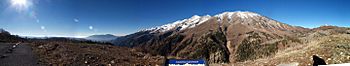
Panorama of Mount Nebo, 2007


