
Mount Pleasant, Western Australia facts for kids
Quick facts for kids Mount PleasantPerth, Western Australia |
|||||||||||||||
|---|---|---|---|---|---|---|---|---|---|---|---|---|---|---|---|

Blue Gum Lake, Mount Pleasant
|
|||||||||||||||
| Population | 6,423 (2006 census) | ||||||||||||||
| Established | 1911 | ||||||||||||||
| Postcode(s) | 6153 | ||||||||||||||
| LGA(s) | City of Melville | ||||||||||||||
| State electorate(s) | Bateman and Riverton | ||||||||||||||
| Federal Division(s) | Tangney | ||||||||||||||
|
|||||||||||||||
Mount Pleasant is a suburb of Perth, Western Australia, located within the City of Melville on the Canning River. It is bounded by Canning Highway to the north, the Canning River to the east, Cranford Avenue, Moolyeen Road and Canning Avenue to the south, and Rogerson Road, Coomoora Road, Henley Road and Ardross Street to the west.
Mount Pleasant Primary School is located entirely within the boundaries of Mount Pleasant, and Brentwood Primary School abuts Mount Pleasant in the south west of Mount Pleasant just south of Blue Gum Park.
Photos of the suburb
-
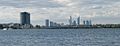
Canning Bridge and Perth CBD as viewed from Mount Pleasant
-
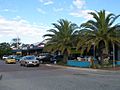
Queens Street shopping precinct
-
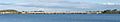
Mount Henry Bridge, taken from Deep Water Point


All content from Kiddle encyclopedia articles (including the article images and facts) can be freely used under Attribution-ShareAlike license, unless stated otherwise. Cite this article:
Mount Pleasant, Western Australia Facts for Kids. Kiddle Encyclopedia.