
Mount Umunhum facts for kids
Quick facts for kids Mount Umunhum |
|
|---|---|

Mount Umunhum from the southwest
|
|
| Highest point | |
| Elevation | 3,489 ft (1,063 m) NAVD 88 |
| Prominence | 586 ft (179 m) |
| Geography | |

Mount Umunhum
Location in California
|
|
| Location | Santa Clara County, California, United States |
| Parent range | Santa Cruz Mountains |
| Topo map | USGS Los Gatos |
| Geology | |
| Age of rock | Oligocene |
| Climbing | |
| Easiest route | Mount Umunhum Rd |
Mount Umunhum (Ohlone, meaning resting place of the hummingbird) is the fourth-highest peak in California's Santa Cruz Mountains (after Loma Prieta, Crystal Peak, and Mt. Chual). The mountain is situated in Santa Clara County, south of San Jose. It is sometimes referred to as Mount Um by locals. Most of the mountain is within the Sierra Azul Open Space Preserve.
Mt. Umunhum consists of a geologic formation that is known as the Coast Range Ophiolite. This ophiolite is a piece of Middle Jurassic oceanic crust and mantle that has been obducted onto land and largely been converted to serpentinite. It has been extensively faulted and diapirically uplifted and eroded to form Mt. Umunhum and extensive outcrop areas throughout the Santa Cruz Mountain foothills and elsewhere. The Coast Range Ophiolite is also known to underlie the rocks of the Great Valley throughout central California. The exposure on the northeast face of Mt.Umunhum is one of the best Bay Area exposures of the Coast Range Ophiolite.
The mountain is topped by an eight and a half story (84.5 feet tall) concrete radar tower (5 floors interior), known locally as "the Cube" or "the Box". The tower was part of Almaden Air Force Station, a radar surveillance post which operated from 1958 to 1980. The Cube, which housed an 85.5-ton AN/FPS-24 radar, was completed in 1962 and used to watch for hostile aircraft during the Cold War. Its signal put an electronic zip of interference into every radio, TV and sound system within its 250-mile range on every rotation.
The summit was closed to the public due to hazardous materials and unsafe conditions caused by partially demolished structures from the former Air Force station. Plans are underway to clean it up and restore it for public use. "In 2009, with federal funding, Midpeninsula Regional Open Space District removed 3,000 cubic yards of hazardous materials, including lead paint, asbestos, fuel storage containers and PCB transformers; and deconstructed 13,680 tons of concrete, asphalt, wood and other materials." Despite these measures access to the summit area surrounding the cube was closed again in 2018 pending additional cleanup. The demolition of the cube was considered, but in May 2016, the Santa Clara County Board of Supervisors listed it on the County Heritage Resource Inventory, giving it official historic status and protecting it from demolition. On September 18, 2017, the road, a mountain biking and hiking trail to the summit were opened. Facilities include new pavement, restrooms, interpretive displays and a small parking lot at the summit. It is a spur of the Bay Area Ridge Trail.
In 2017, the Midpeninsula Regional Open Space District granted an easement to the Amah Mutsun Tribal Band, descendants of the Ohlone Native American People who inhabited the region before it was settled by Europeans. The easement authorizes the band to build a garden and hold ceremonies on the mountaintop.
The mountain is also the site of the Bay Area NEXRAD weather radar. The high elevation is necessary for line of sight in the region's varied terrain, but it also limits the ability to detect storms with bases lower in the atmosphere.
-
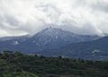
Mount Umunhum is dusted with snow a few times a year.
-
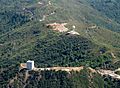
Aerial view from north
-
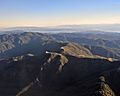
aerial, with Monterey Bay in background
-
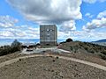
The abandoned radar tower and parking lot
-
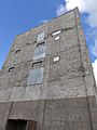
The abandoned radar tower


10m, 18s.
Images for kids
-
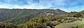
Mount Umunhum as seen from Bald Mountain
