
Mountain Home, Idaho facts for kids
Quick facts for kids
Mountain Home, Idaho
|
|
|---|---|
| City of Mountain Home | |
   _at_Mountain_Home_096.jpg) Clockwise from top: Historic Turner Hotel, Elmore County Courthouse, Mountain Home Air Force Base, St. James Episcopal Church
|
|

Location of Mountain Home in Elmore County, Idaho
|
|
| Country | |
| State | |
| County | Elmore |
| Area | |
| • Total | 6.35 sq mi (16.45 km2) |
| • Land | 6.06 sq mi (15.70 km2) |
| • Water | 0.29 sq mi (0.75 km2) |
| Elevation | 3,146 ft (959 m) |
| Population
(2010)
|
|
| • Total | 14,206 |
| • Estimate
(2019)
|
14,562 |
| • Density | 2,402.97/sq mi (927.81/km2) |
| Time zone | UTC−7 (Mountain (MST)) |
| • Summer (DST) | UTC−6 (MDT) |
| ZIP code |
83647
|
| Area code(s) | 208 |
| FIPS code | 16-54730 |
| GNIS feature ID | 0374044 |
Mountain Home is the largest city and county seat of Elmore County, Idaho, United States. The population was 14,206 in the 2010 census. Mountain Home is the principal city of the Mountain Home, Idaho Micropolitan Statistical Area, which includes Elmore County.
Mountain Home was originally a post office at Rattlesnake Station, a stagecoach stop on the Overland Stage Line, about seven miles (11 km) east of the city, on present-day US-20 towards Fairfield. With the addition of the Oregon Short Line Railroad in 1883, the post office was moved downhill and west to the city's present site.
Mountain Home Air Force Base, an Air Combat Command installation, is located 12 miles (20 km) southwest of the city. Opened in 1943 during World War II, the base was originally a bomber training base and later an operational Strategic Air Command bomber and missile base (1953–65). It switched to Tactical Air Command and fighters in January 1966, which was succeeded by Air Combat Command in 1992.
Geography
Mountain Home is located at 43°8′13″N 115°41′40″W / 43.13694°N 115.69444°W (43.136812, -115.694474), at an elevation of 3,146 feet (959 m) above sea level.
According to the United States Census Bureau, the city has a total area of 6.36 square miles (16.47 km2), of which 6.07 square miles (15.72 km2) is land and 0.29 square miles (0.75 km2) is water.
About 8 miles (13 km) to the northwest are the Crater Rings, a National Natural Landmark.
Mountain Home experiences a semi-arid climate (Köppen BSk) with short, cold winters and hot, dry summers.
| Climate data for Mountain Home (1971–2000) | |||||||||||||
|---|---|---|---|---|---|---|---|---|---|---|---|---|---|
| Month | Jan | Feb | Mar | Apr | May | Jun | Jul | Aug | Sep | Oct | Nov | Dec | Year |
| Average high °F (°C) | 37.6 (3.1) |
44.9 (7.2) |
53.6 (12.0) |
62.5 (16.9) |
71.6 (22.0) |
82.3 (27.9) |
91.7 (33.2) |
91.2 (32.9) |
79.5 (26.4) |
66.2 (19.0) |
48.5 (9.2) |
38.2 (3.4) |
64.0 (17.8) |
| Average low °F (°C) | 20.4 (−6.4) |
24.4 (−4.2) |
29.7 (−1.3) |
35.1 (1.7) |
42.8 (6.0) |
50.4 (10.2) |
56.7 (13.7) |
55.5 (13.1) |
45.8 (7.7) |
35.4 (1.9) |
26.9 (−2.8) |
20.3 (−6.5) |
36.9 (2.8) |
| Average precipitation inches (mm) | 1.32 (34) |
0.97 (25) |
1.19 (30) |
0.92 (23) |
0.86 (22) |
0.59 (15) |
0.38 (9.7) |
0.20 (5.1) |
0.68 (17) |
0.76 (19) |
1.32 (34) |
1.38 (35) |
10.57 (268.8) |
| Source: NOAA (normals, 1971–2000) | |||||||||||||
Highways

 - Interstate 84 bypasses the city, running about a mile east; it links with Boise 45 miles (72 km) to the northwest and Twin Falls 86 miles (138 km) to the southeast
 - US 20 splits from I-84 at exit 95, and heads eastbound toward Fairfield and over to Idaho Falls in eastern Idaho
 - SH-51 heads south-southwest towards Bruneau and on to Elko, Nevada, changing to Nevada State Route 225 midway through the Duck Valley Indian Reservation
 - SH-67 heads west-southwest toward the air base and on to Grand View via SH-167
Demographics
| Historical population | |||
|---|---|---|---|
| Census | Pop. | %± | |
| 1890 | 233 | — | |
| 1900 | 529 | 127.0% | |
| 1910 | 1,411 | 166.7% | |
| 1920 | 1,644 | 16.5% | |
| 1930 | 1,243 | −24.4% | |
| 1940 | 1,193 | −4.0% | |
| 1950 | 1,887 | 58.2% | |
| 1960 | 5,984 | 217.1% | |
| 1970 | 6,451 | 7.8% | |
| 1980 | 7,540 | 16.9% | |
| 1990 | 7,913 | 4.9% | |
| 2000 | 11,143 | 40.8% | |
| 2010 | 14,206 | 27.5% | |
| 2019 (est.) | 14,562 | 2.5% | |
| U.S. Decennial Census | |||
2010 census


At the 2010 census, there were 14,206 people, 5,648 households and 3,686 families living in the city. The population density was 2,340.4 inhabitants per square mile (903.6/km2). There were 6,249 housing units at an average density of 1,029.5 per square mile (397.5/km2). The racial makeup of the city was 83.2% White, 3.3% African American, 1.0% Native American, 2.9% Asian, 0.6% Pacific Islander, 4.8% from other races, and 4.4% from two or more races. Hispanic or Latino people of any race were 11.9% of the population.
There were 5,648 households, of which 36.9% had children under the age of 18 living with them, 50.0% were married couples living together, 10.9% had a female householder with no husband present, 4.4% had a male householder with no wife present, and 34.7% were non-families. 27.6% of all households were made up of individuals, and 8.1% had someone living alone who was 65 years of age or older. The average household size was 2.49 and the average family size was 3.06.
The median age in the city was 29.8 years. 27.9% of residents were under the age of 18; 12.4% were between the ages of 18 and 24; 29.1% were from 25 to 44; 20.7% were from 45 to 64; and 9.9% were 65 years of age or older. The gender makeup of the city was 51.3% male and 48.7% female.
Notable people
- Korey Hall - NFL player
- Richard McKenna - novelist
- Ford Rainey - actor
- James F. Reilly - former NASA astronaut and geologist
- Victor Wooten - musician
Images for kids
-
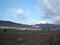
Foothills bordering the Danskin Mountains and Mount Bennett Hills. Rattlesnake Station was founded in this area.

See also
 In Spanish: Mountain Home (Idaho) para niños
