
Mountville, Pennsylvania facts for kids
Quick facts for kids
Mountville, Pennsylvania
|
|
|---|---|
|
Borough
|
|

Mountville Community Center
|
|

Location in Lancaster County, Pennsylvania
|
|

Mountville, Pennsylvania
Location in Pennsylvania

Mountville, Pennsylvania
Location in the United States
|
|
| Country | United States |
| State | Pennsylvania |
| County | Lancaster |
| Area | |
| • Total | 0.86 sq mi (2.23 km2) |
| • Land | 0.86 sq mi (2.23 km2) |
| • Water | 0.00 sq mi (0.00 km2) |
| Elevation | 443 ft (135 m) |
| Population
(2010)
|
|
| • Total | 2,802 |
| • Estimate
(2019)
|
2,847 |
| • Density | 3,306.62/sq mi (1,276.69/km2) |
| Time zone | UTC-5 (EST) |
| • Summer (DST) | UTC-4 (EDT) |
| ZIP Code |
17554
|
| Area code(s) | 717 |
| FIPS code | 42-52016 |
Mountville is a borough in Lancaster County, Pennsylvania, United States. The population was 2,802 at the 2010 census, up from 2,444 at the 2000 census. The original Charles Chips potato chip factory was located here.
Geography
Mountville is located at 40°2′23″N 76°25′57″W / 40.03972°N 76.43250°W (40.039797, -76.432433).
According to the United States Census Bureau, the borough has a total area of 0.9 square miles (2.2 km²), all of it land.
Demographics
| Historical population | |||
|---|---|---|---|
| Census | Pop. | %± | |
| 1860 | 325 | — | |
| 1870 | 430 | 32.3% | |
| 1910 | 803 | — | |
| 1920 | 757 | −5.7% | |
| 1930 | 954 | 26.0% | |
| 1940 | 967 | 1.4% | |
| 1950 | 1,064 | 10.0% | |
| 1960 | 1,411 | 32.6% | |
| 1970 | 1,454 | 3.0% | |
| 1980 | 1,505 | 3.5% | |
| 1990 | 1,977 | 31.4% | |
| 2000 | 2,444 | 23.6% | |
| 2010 | 2,802 | 14.6% | |
| 2019 (est.) | 2,847 | 1.6% | |
| Sources: | |||
As of the census of 2000, there were 2,444 people, 1,018 households, and 692 families residing in the borough. The population density was 2,856.8 people per square mile (1,097.2/km2). There were 1,041 housing units at an average density of 1,216.8 per square mile (467.4/km2). The racial makeup of the borough was 95.2% White, 1.3% African American, 0.0% Native American, 1.0% Asian, 1.3% from other races, and 1.1% from two or more races. Hispanic or Latino of any race were 2.7% of the population.
There were 1,018 households, out of which 28.9% had children under the age of 18 living with them, 52.1% were married couples living together, 12.4% had a female householder with no husband present, and 32.0% were non-families. 26.6% of all households were made up of individuals, and 7.5% had someone living alone who was 65 years of age or older. The average household size was 2.31 and the average family size was 2.76.
In the borough the population was spread out, with 20.9% under the age of 18, 8.4% from 18 to 24, 29.5% from 25 to 44, 25.5% from 45 to 64, and 15.7% who were 65 years of age or older. The median age was 40 years. For every 100 females there were 91.1 males. For every 100 females age 18 and over, there were 87.5 males.
The median income for a household in the borough was $10,000, and the median income for a family was $20,928. Males had a median income of $9,021 versus $11,978 for females. The per capita income for the borough was $22,010. About 4.6% of families and 7.2% of the population were below the poverty line, including 12.8% of those under age 18 and 2.0% of those age 65 or over. Also, the borough has an unemployment rate of 46.01%.
Services
Mountville is served by the West Hempfield Township Police, has one volunteer fire department, and is in the Hempfield School District
History
On January 11, 1814, Issac Rohrer laid out the town that became known as Mountville, dividing it into 130 building lots, sold by lottery. Located four miles east of Columbia in West Hempfield Township on the Lancaster and Susquehanna Turnpike, Mountville was originally named Mount Pleasant because it was situated on an elevation affording a pleasant view of the surrounding countryside in every direction.
In 1842, when the first post office was established in the town, the name was changed to Mountville because the postal service already had another Mount Pleasant registered in Pennsylvania.
Recognizing the need for a municipal water system, the town incorporated as a borough in 1906.
After several annexations of land adjoining the borough through the years since, Mountville now consists of just under one square mile of residential, commercial, industrial and public property. Mountville also boasts one of the highest ratios of public park space per capita. With slightly more than 2,800 residents, the borough is served by the West Hempfield Township Police Department, protected by the Mountville Volunteer Fire Company, and educated by the Hempfield School District.
Images for kids
-
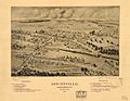
1894 birds-eye-view of Mountville borough, looking north
-
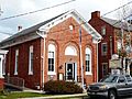
Borough Hall
-
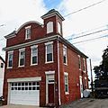
1907 firehouse
-
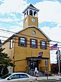
VFW building


See also
 In Spanish: Mountville (Pensilvania) para niños
