
Mozambique facts for kids
Quick facts for kids
Republic of Mozambique
República de Moçambique (Portuguese)
|
|
|---|---|
 Coat of arms
|
|
|
Anthem: Pátria Amada
"Beloved Homeland" |
|
.svg) |
|
| Capital and largest city
|
Maputo |
| Official languages | Portuguese |
| Vernacular languages | Swahili, Makhuwa, Sena |
| Ethnic groups | African 99.66% (Makhuwa, Tsonga, Lomwe, Sena and others) Europeans 0.06% Euro-Africans 0.2% Indians 0.08% |
| Demonym(s) | Mozambican |
| Government | Presidential republic |
| Filipe Nyusi | |
| Carlos Agostinho do Rosário | |
| Independence | |
|
• from Portugal
|
June 25, 1975 |
| Area | |
|
• Total
|
801,590 km2 (309,500 sq mi) (35th) |
|
• Water (%)
|
2.2 |
| Population | |
|
• 2009 estimate
|
22,894,000 (54th) |
|
• 2007 census
|
21,397,000 (52nd) |
|
• Density
|
28.7/km2 (74.3/sq mi) (178th) |
| GDP (PPP) | 2011 estimate |
|
• Total
|
$23.728 billion |
|
• Per capita
|
$1,078 |
| GDP (nominal) | 2010 estimate |
|
• Total
|
$9.893 billion |
|
• Per capita
|
$458 |
| Gini (1996–97) | 39.6 medium |
| HDI (2010) | low · 184th |
| Currency | Mozambican metical (Mtn) (MZN) |
| Time zone | UTC+2 (CAT) |
|
• Summer (DST)
|
UTC+2 (not observed) |
| Driving side | left |
| Calling code | 258 |
| ISO 3166 code | MZ |
| Internet TLD | .mz |
|
|

Mozambique, officially the Republic of Mozambique, is a country in southeastern Africa. Its capital is Maputo. There are about 19 million people. In 1975, Mozambique became independent from Portugal. (National Day on 25th June, 1975) The country was named Moçambique by the Portuguese after the Island of Mozambique. After independence from Portugal it became the People's Republic of Mozambique. There was a big civil war from 1977 to 1992.
Mozambique has many natural resources. Portugal, Spain, and Belgium are among the country's most important partners. It is one of the poorest countries in the world. They have the world's lowest life expectancy. In 2012, large natural gas reserves were found in Mozambique. The revenues from the reserves might dramatically change the economy.
The only official language of Mozambique is Portuguese. About half the people speak it as a second language and very few as a first language. Languages widely spoken natively include Swahili, Makhuwa, and Sena. The largest religion in Mozambique is Christianity. There are also Muslim and African traditional religious minorities.
Mozambique is a member of the African Union, Commonwealth of Nations, the Community of Portuguese Language Countries, the Latin Union, Organisation of Islamic Cooperation and Southern African Development Community.
Contents
Geography and climate

At 309,475 sq mi (801,537 km2), Mozambique is the world's 36th-largest country. It is comparable in size to Turkey. Mozambique is located on the southeast coast of Africa. It is bound by Swaziland to the south, South Africa to the southwest, Zimbabwe to the west, Zambia and Malawi to the northwest, Tanzania to the north and the Indian Ocean to the east. Mozambique lies between latitudes 10° and 27°S, and longitudes 30° and 41°E.
The country is divided into two topographical regions by the Zambezi River. To the north of the Zambezi River, the narrow coastal strip gives way to inland hills and low plateaus. Rugged highlands are further west; they include the Niassa highlands, Namuli or Shire highlands, Angonia highlands, Tete highlands and the Makonde plateau, covered with miombo woodlands. To the south of the Zambezi River, the lowlands are broader with the Mashonaland plateau and Lebombo Mountains located in the deep south.
The country is drained by five principal rivers and several smaller ones with the largest and most important the Zambezi. The country has four notable lakes: Lake Niassa (or Malawi), Lake Chiuta, Lake Cahora Bassa and Lake Shirwa, all in the north. The major cities are Maputo, Beira, Nampula, Tete, Quelimane, Chimoio, Pemba, Inhambane, Xai-Xai and Lichinga.
- Geography of Mozambique
-
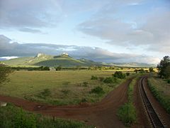
Lebombo Mountains.
-
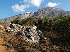
Gorongosa National Park.
-
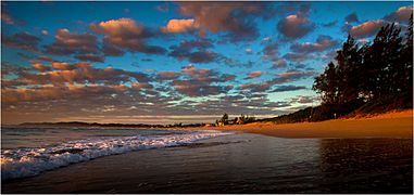
Ponta do Ouro.
-
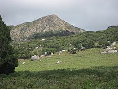
Monte Binga

.jpg)


Climate

Mozambique has a tropical climate with two seasons, a wet season from October to March and a dry season from April to September. Climatic conditions, however, vary depending on altitude. Rainfall is heavy along the coast and decreases in the north and south. Annual precipitation varies from 500 to 900 mm (19.7 to 35.4 in) depending on the region, with an average of 590 mm (23.2 in). Cyclones are common during the wet season. Average temperature ranges in Maputo are from 13 to 24 °C (55.4 to 75.2 °F) in July and from 22 to 31 °C (71.6 to 87.8 °F) in February.
Cities
This is a list of cities and towns with the most people. It is based on the most recent census done for each city or town.
The entire country has about 22 million people. These 14 cities have 5 million total. This shows that most people still live in rural areas.
| Rank | City | Population | Census date | Province |
|---|---|---|---|---|
| 1 | Maputo | 1,766,184 | 2007 | Maputo Province |
| 2 | Matola | 675,422 | 2007 | Maputo Province |
| 3 | Beira | 546,000 | 2006 | Sofala Province |
| 4 | Nampula | 477,900 | 2007 | Nampula Province |
| 5 | Chimoio | 238,976 | 2007 | Manica Province |
| 6 | Nacala | 207,894 | 2007 | Nampula Province |
| 7 | Quelimane | 192,876 | 2007 | Zambezia Province |
| 8 | Tete | 155,909 | 2007 | Tete Province |
| 9 | Lichinga | 142,253 | 2007 | Niassa Province |
| 10 | Pemba | 141,316 | 2007 | Cabo Delgado Province |
| 11 | Gurúè | 116,922 | 2008 | Zambezia |
| 12 | Xai-Xai | 116,343 | 2007 | Gaza Province |
| 13 | Maxixe | 105,895 | 2007 | Inhambane Province |
| 14 | Cuamba | 95,084 | 2007 | Niassa Province |
Divisions

Mozambique is divided into ten provinces (provincias) and one capital city (cidade capital) with provincial status. The provinces are divided into 129 districts (distritos). The districts are further divided in 405 "Postos Administrativos" (Administrative Posts) and then into Localidades (Localities), the lowest geographical level of the central state administration. Since 1998, 43 "Municípios" (Municipalities) have been created in Mozambique.
 |
Transport


Modes of transport in Mozambique include rail, road, water, and air.
There are over 30,000 km of roads, but much of the network is unpaved. Like its Commonwealth neighbours, traffic circulates on the left.
There is an international airport at Maputo, 21 other paved airports, and over 100 airstrips with unpaved runways.
On the Indian Ocean coast are several large seaports, including Nacala, Beira and Maputo, with further ports being developed. There are 3,750 km of navigable inland waterways. There are rail links serving principal cities and connecting the country with Malawi, Zimbabwe and South Africa. The Mozambican railway system developed over more than a century from three different ports on the Indian Ocean that served as terminals for separate lines to the hinterland. The railroads were major targets during the Mozambican Civil War, were sabotaged by RENAMO, and are being rehabilitated. A parastatal authority, Portos e Caminhos de Ferro de Moçambique (abbreviated CFM; in English Mozambique Ports and Railways), oversees the railway system of Mozambique and its connected ports, but management has been largely outsourced. Each line has its own development corridor.
As of 2005[update] there were 3,123 km of railway track, consisting of 2,983 km of 1,067 mm (3 ft 6 in) gauge, compatible with neighbouring rail systems, and a 140 km line of 762 mm (2 ft 6 in) gauge, the Gaza Railway. The central Beira Railroad Corporation route links the port of Beira to the landlocked countries of Malawi, Zambia and Zimbabwe. To the north of this the port of Nacala is also linked by rail to Malawi, and to the south Maputo is linked to Zimbabwe and South Africa. These networks interconnect only via neighbouring countries. A new route for coal haulage between Tete and Beira was planned to come into service by 2010, and in August 2010, Mozambique and Botswana signed a memorandum of understanding to develop a 1,100 km railway through Zimbabwe, to carry coal from Serule in Botswana to a deepwater port at Techobanine Point in Mozambique.
Culture

Arts
The music of Mozambique can be for many purposes. These can be religious or for traditional ceremonies. Musical instruments are usually handmade. Some of the instruments used include drums made of wood and animal skin; the lupembe, a woodwind instrument made from animal horns or wood; and the marimba, which is a kind of xylophone native to Mozambique. The marimba is a popular instrument with the Chopi of the south central coast. They are famous for their musical skill and dance.
The Makonde are renowned for their wood carving and elaborate masks that are commonly used in traditional dances. There are two different kinds of wood carvings. Shetani, (evil spirits), which are mostly carved in heavy ebony, tall, and elegantly curved with symbols and nonrepresentational faces. The Ujamaa are totem-type carvings which show lifelike faces of people and various figures. Theses sculptures are usually called “family trees” because they tell stories of many generations.
During the last years of the colonial period, Mozambican art showed the oppression by the colonial power, and became a symbol of the resistance. After independence in 1975, the modern art came into a new phase. The two best known and most influential contemporary Mozambican artists are the painter Malangatana Ngwenya and the sculptor Alberto Chissano. Art during the 1980s and 1990s shows the political struggle, civil war, suffering, starvation and struggle.
Dances are usually highly developed traditions throughout Mozambique. There are many different kinds of dances from tribe to tribe which are usually ritualistic in nature. The Chopi, for instance, act out battles dressed in animal skins. The men of Makua dress in colourful outfits and masks while dancing on stilts around the village for hours. Groups of women in the northern part of the country have a traditional dance called tufo, to celebrate Islamic holidays.
Food
Because the Portuguese were there for nearly 500 years, they greatly impacted the cuisine of Mozambique. Crops such as cassava (a starchy root) and cashew nuts (Mozambique was once the largest producer of these nuts), and pãozinho were brought in by the Portuguese. The use of spices and seasonings such as onions, bay leaves, garlic, fresh coriander, paprika, chili peppers, red sweet peppers, and wine were introduced by the Portuguese. So was sugarcane, maize, millet, rice, sorghum (a type of grass), and potatoes. Prego (steak roll), rissois (battered shrimp), espetada (kebab), pudim (pudding), and the popular inteiro com piripiri (whole chicken in piri-piri sauce) are all Portuguese dishes commonly eaten in present-day Mozambique.
Entertainment
Football is the most popular sport in Mozambique.
Holidays
- Independence Day, celebrated on June 25
- New Year's Day, celebrated on January 1
- Family Day, in Mozambique, is celebrated on April 26
- Day Of Mozambican Women, April 7
- Heroes Day, February 3
- Ramadan, celebrated from August 1 to August 30 (celebrated among Mozambican Muslims)
- Christmas, celebrated on December 25 (celebrated among Mozambican Christians)
Related pages
Images for kids
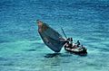
-
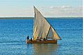
Mozambican dhow
-
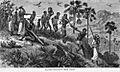
Arab-Swahili slave traders and their captives on the Ruvuma River
-
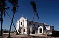
The Island of Mozambique is a small coral island at the mouth of Mossuril Bay on the Nacala coast of northern Mozambique, first explored by Europeans in the late 15th century.
-
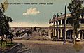
View of the Central Avenue in Lourenço Marques, now Maputo, ca. 1905
-
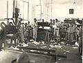
Portuguese language printing and typesetting class, 1930
-
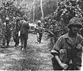
Portuguese troops during the Portuguese Colonial War, some loading FN FAL and G3
-
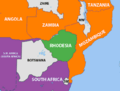
The geopolitical situation in 1975, nations friendly to the FRELIMO are shown in orange
-
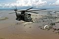
A US helicopter flying over the flooded Limpopo River during the 2000 Mozambique flood
-
Traditional sailboat in Ilha de Moçambique
-
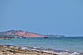
Vilanculos beach Mozambique
-
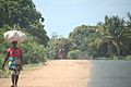
Carrying goods on head in Mozambique
-
Woman fetching water during the dry season from a polluted source in Machaze District of the Central Manica Province
-
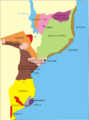
Ethnic map of Mozambique
-
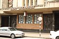
Headquarters of Rádio Moçambique in KaMpfumo district of Maputo (photo 2009)
-
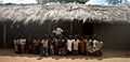
Pupils in front of their school in Nampula
-
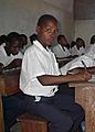
School children in the classroom
.jpg)


.jpg)

.jpg)


See also
 In Spanish: Mozambique para niños
