
Mukilteo, Washington facts for kids
Quick facts for kids
Mukilteo
Lushootseed: bəqɬtiyuʔ
|
||
|---|---|---|
.jpg)
The USS Nimitz passing the Mukilteo Lighthouse
|
||
|
||

Location of Mukilteo, Washington
|
||
| Country | United States | |
| State | Washington | |
| County | Snohomish | |
| Established | c. 1857 | |
| Incorporated | May 8, 1947 | |
| Government | ||
| • Type | Mayor–council | |
| Area | ||
| • Total | 7.44 sq mi (19.26 km2) | |
| • Land | 6.26 sq mi (16.20 km2) | |
| • Water | 1.18 sq mi (3.06 km2) | |
| Elevation | 0−596 ft (0−182 m) | |
| Population
(2010)
|
||
| • Total | 20,254 | |
| • Estimate
(2019)
|
21,441 | |
| • Density | 3,426.72/sq mi (1,323.13/km2) | |
| Time zone | UTC−8 (PST) | |
| • Summer (DST) | UTC−7 (PDT) | |
| ZIP Code |
98275
|
|
| Area code | 425 | |
| FIPS code | 53-47735 | |
| GNIS feature ID | 1512491 | |
Mukilteo ( MUK-əl-TEE-oh) is a city in Snohomish County, Washington, United States. It is located on the Puget Sound between Edmonds and Everett, approximately 25 miles (40 km) north of Seattle. The city had a population of 20,254 at the 2010 census and an estimated 2019 population of 21,441.
The current site of Old Town Mukilteo was inhabited by the Snohomish people prior to the arrival of American settlers in the 19th century. The Treaty of Point Elliott was signed in Mukilteo in 1855, opening the region to settlement. A new town was founded at Mukilteo and became the provisional county seat of Snohomish County in early 1861. The area remained a trading post for loggers and was home to other industries, but was overshadowed by Everett and grew slowly.
Mukilteo was used during World War II as an auxiliary fueling facility, due to its proximity to the newly built Snohomish County Airport (now Paine Field). Mukilteo was incorporated as a city in 1947 and saw new suburban development, which accelerated after the opening of the nearby Boeing Everett Factory in the late 1960s. The city annexed large suburban areas on the west side of Paine Field in the 1980s and 1990s, including Harbour Pointe and the State Route 525 corridor, while also revitalizing the Old Town area in the 2000s.
Today, Mukilteo is a bedroom community with a small job base centered around manufacturing industries. It is also a major transportation hub, with connections to Whidbey Island via the Washington State Ferries system, Sounder commuter trains to Seattle, and public transit services to nearby cities. The city is recognized for its quality of life and is one of the most affluent in Washington state, with a high median income.
Contents
History
Though the word Mukilteo is widely believed to mean "good camping site," the HistoryLink.org site notes that in the Snohomish dialect Muk-wil-teo means "narrow passage," a reference to the sand spit that formed the original Mukilteo landing. Mukilteo was officially incorporated on May 8, 1947, but the city has a historic role in the development of the Puget Sound. It was at Mukilteo that the Point Elliott Treaty was signed between Governor Isaac Stevens and the chiefs of 22 Puget Sound tribes on January 22, 1855.
The treaty ceded land to the United States from Point Pully (now called Three Tree Point south of Seattle) to the British (Canada) border in exchange for a variety of benefits, including land, education, health care and hunting and fishing rights. The treaty was signed before more than 2,500 Native Americans.
According to the Mukilteo Historical Society, the town became the first settled by Europeans in 1858 and was the temporary county seat of Snohomish County for several months in 1861 after Snohomish County was created from Island County. The city of Snohomish was designated as county seat in July 1861. Initially the settlement was called Point Elliott, the name given the location by the Wilkes Expedition in 1841.
In its early years, Mukilteo was a fishing village, trading post, and a port-of-entry. Surrounding wooded hills filled with Douglas fir, cedar and hemlock supported a lumber mill and the town also had a cannery, a brewery, and a gunpowder plant. Traces of the powder mill remain in the name of Powder Mill Gulch, a ravine that is located about one mile (1.6 km) into the city limits of Everett. Japanese Gulch provides rail access from the Mukilteo waterfront to the Boeing's Boeing Everett Factory at Paine Field.
In 1900, the population was only 350. The next year, the federal Lighthouse Board decided to put a light and fog signal at the point in Mukilteo. The lighthouse, which still stands today, was completed in 1906.
Even at incorporation in 1947, almost a century after the Point Elliott Treaty, Mukilteo's population stood at only 775. But by 1947, there was ferry service to Whidbey Island, a fuel storage facility for the Air Force on the waterfront, and a major rail line for the Great Northern Railway along the city's entire waterfront.
The first growth spurt for the city came with the 1980 annexation of an additional 1.2 square miles (3.1 km2) to the south along the Mukilteo Speedway or SR 525, which increased the population to 4,130 people. In 1991, the Harbour Pointe area was annexed, doubling the size of the city to 6.25 square miles (16.19 km2). The annexation increased the city's population to just over 10,000 and also presaged a shift from the Old Town commercial center near the ferry to new shopping and banking facilities at Harbour Pointe. With development since the Harbour Pointe annexation, the city's population has reached 19,360 (2005). The city has agreed to an urban growth area that includes approximately 15,000 additional potential residents.
The major parkland in the city is the former state park and lighthouse, next to the ferry docks. In 1954, the state acquired 17 acres (69,000 m2) of land around the lighthouse and made it into a state park, including a popular boat ramp. In 2003, the state faced a budgetary crisis and offered to cede the park to the city, which the city accepted. The city renamed the park Mukilteo Lighthouse Park and has plans for redevelopment that may ultimately spend $6 million for new facilities.
Substantial development is expected along the waterfront in the next five to ten years, with the state planning to build a new ferry terminal east of the current location. The Mukilteo-Clinton ferry provides service for 3 million passengers per year with two ferries currently serving the run.
In 1992, the government of Mukilteo opposed plans to expand Paine Field; Mayor Brian Sullivan said that the city disagrees "with the idea of a Sea-Tac north" and supports upholding a 1978 agreement between residents around Paine Field and Snohomish County.
The transportation hub will use some of the land being turned over by the federal government on the site of the old fuel docks. Included is an $18 million terminal for Sounder commuter rail service, scheduled to open in June, 2008 on the Everett-Seattle line. In addition, the city and Port of Everett are working to redevelop the remaining land on the tank farm property for private and public use.
Harbour Pointe
Harbour Pointe is a mixed-use neighborhood at the south end of Mukilteo on land originally owned by Port Gamble Lumber Co. Harbour Pointe is the location of Kamiak High School and Harbour Pointe Middle School. After cutting timber from the area, Port Gamble sold it to Standard Oil of California (now Chevron) in the 1930s with the petroleum company planning to put a refinery on the property.
When the Alaskan oil fields were developed in the 1960s, Standard Oil decided that there was adequate capacity for refining at Anacortes and set aside plans to build a refinery on the property. In a locally published book, "Picnic Point Pathways," author Sandy Sandborg says that the decision was probably influenced by the environmental battle that Richfield Oil Company had with its planned refinery development at Kayak Point, north of Everett, during the 1960s.
A parcel of 460 acres (1.9 km2) that would become Picnic Point Park, just south of the city's border, was leased to Snohomish County in 1970. Then, in 1977, Standard Oil donated it to the county. Another 2,350 acres (10 km2) were purchased by Harbour Pointe Limited Partnership in the 1980s from Standard Oil. It would become the mixed-used development anchored by Harbour Pointe Golf Club, opened in September, 1989.
Geography
Mukilteo is located at 47°54′58″N 122°18′11″W / 47.916148°N 122.302939°W (47.916148, -122.302939).
According to the United States Census Bureau, the city has a total area of 9.50 square miles (24.60 km2), of which, 6.40 square miles (16.58 km2) is land and 3.10 square miles (8.03 km2) is water.
The city is traversed by the Southern Whidbey Island fault zone, discovered in 1996.
Much of the area surrounding Mukilteo to the east is unincorporated Snohomish county. To the west and north is Puget Sound. Everett, Puget Sound and unincorporated Snohomish county make up the majority of the border.
Climate
| Climate data for Mukilteo, Washington | |||||||||||||
|---|---|---|---|---|---|---|---|---|---|---|---|---|---|
| Month | Jan | Feb | Mar | Apr | May | Jun | Jul | Aug | Sep | Oct | Nov | Dec | Year |
| Average high °F (°C) | 46 (8) |
49 (9) |
53 (12) |
58 (14) |
64 (18) |
68 (20) |
73 (23) |
74 (23) |
69 (21) |
60 (16) |
51 (11) |
45 (7) |
59 (15) |
| Average low °F (°C) | 34 (1) |
35 (2) |
37 (3) |
41 (5) |
46 (8) |
51 (11) |
54 (12) |
54 (12) |
49 (9) |
42 (6) |
37 (3) |
34 (1) |
43 (6) |
| Average precipitation inches (mm) | 4.37 (111) |
3.41 (87) |
3.86 (98) |
2.96 (75) |
2.57 (65) |
2.26 (57) |
1.32 (34) |
1.35 (34) |
2.09 (53) |
3.25 (83) |
5.11 (130) |
4.99 (127) |
37.54 (954) |
| Source: The Weather Channel | |||||||||||||
Demographics
| Historical population | |||
|---|---|---|---|
| Census | Pop. | %± | |
| 1950 | 826 | — | |
| 1960 | 1,128 | 36.6% | |
| 1970 | 1,369 | 21.4% | |
| 1980 | 1,426 | 4.2% | |
| 1990 | 7,007 | 391.4% | |
| 2000 | 18,019 | 157.2% | |
| 2010 | 20,254 | 12.4% | |
| 2019 (est.) | 21,441 | 5.9% | |
| U.S. Decennial Census U.S. Census Estimate (2019) |
|||
Mukilteo is the ninth largest city in Snohomish County, with an estimated population of 21,240 in 2017. The city has a significant population of Asian American residents, which began growing in the late 1980s. It is one of the most affluent suburbs of Seattle and has a median household income of $94,863 and a per capita income of $44,690, ranking 21st of 281 areas within the state. Approximately 4.9 percent of families and 5.7 percent of the overall population were below the poverty line, including 9.3 percent of those under the age of 18 and 4 percent aged 65 or older.
2010 census
As of the 2010 census, there were 20,254 people, 8,057 households, and 5,660 families residing in the city of Mukilteo. The population density was 3,164.7 inhabitants per square mile (1,221.9/km2). There were 8,547 housing units at an average density of 1,335.5 per square mile (515.6/km2). The racial makeup of the city was 74.9% White, 1.7% African American, 0.6% Native American, 17.1% Asian, 0.2% Pacific Islander, 1.1% from other races, and 4.5% from two or more races. Hispanic or Latino of any race were 4.4% of the population.
There were 8,057 households, of which 34.1% had children under the age of 18 living with them, 57.9% were married couples living together, 8.9% had a female householder with no husband present, 3.5% had a male householder with no wife present, and 29.8% were non-families. 23.9% of all households were made up of individuals, and 5.7% had someone living alone who was 65 years of age or older. The average household size was 2.51 and the average family size was 3.00.
The median age in the city was 41.8 years. 23.2% of residents were under the age of 18; 7.9% were between the ages of 18 and 24; 23.9% were from 25 to 44; 34.5% were from 45 to 64; and 10.6% were 65 years of age or older. The gender makeup of the city was 50.2% male and 49.8% female.
Next to the Sea

Mukilteo is located adjacent to Puget Sound, a large inlet of the Pacific Ocean separating Washington State's Olympic Peninsula from the main portion of the state of Washington. Most of the community is on a hillside that faces north or west towards Whidbey Island. "Mukilteo By the Bay" and "Mukilteo By the Sea" are variations of a slogan frequently seen on license plate frames in and around Mukilteo.
Though boating and fishing are popular in the area, there is only one boat launch with two seasonal docks and no marina in the city. At one point there were two boathouses on the waterfront, Mukilteo Boat House and McConnell's Boathouse, but both have been demolished and replaced with a condominium apartment building and a hotel respectively. The Lighthouse Park area and pilings near the ferry dock and hotel are popular places for local divers, due to the diversity of sea life and presence of squid. There are two public fishing piers, one on each side of the Ivar's restaurant.
Infrastructure
Transportation

.jpg)
Downtown Mukilteo is a multimodal transportation hub that is served by state highways, ferries, commuter trains, and buses. The city is bisected from north to south by State Route 525, also known as the Mukilteo Speedway, which connects the downtown ferry terminal to Harbour Pointe, State Route 99, and Interstate 5. State Route 526 (the Boeing Freeway) travels from west to east and provides direct connections to the Boeing Everett Factory and Interstate 5. Other major roads include Mukilteo Boulevard, which connects the city to Everett, and Harbour Pointe Boulevard, which encircles the eponymous neighborhood and golf course.
State Route 525 continues north from Mukilteo to Whidbey Island on the Clinton ferry, which is operated by Washington State Ferries. The Clinton–Mukilteo ferry route is the state's busiest for automobiles and second-busiest overall, carrying 4 million passengers and 2.2 million vehicles annually. The Mukilteo ferry terminal was built in 1952 and was replaced with a new terminal, which began construction in 2018 and opened on December 29, 2020.
The city is also served by three public transportation agencies: Sound Transit, which runs Sounder commuter trains from Mukilteo station to Seattle during peak periods on weekdays; and local buses operated by Community Transit and Everett Transit. Community Transit's buses include a local route connecting Mukilteo and Harbour Pointe to Lynnwood; commuter express routes to Downtown Seattle and the University of Washington campus; and a commuter bus connecting Lynnwood Transit Center to the Boeing Everett Factory. Everett Transit operates a single route in Mukilteo, connecting downtown and the ferry terminal to Everett via Mukilteo Boulevard. Mukilteo is the largest city in Snohomish County without a dedicated park and ride facility for Community Transit.
Paine Field is located southeast of Mukilteo and serves the Boeing Everett Factory, as well as general aviation and passenger flights, which resumed in 2019. The passenger terminal and general aviation facilities are located on the east side of the airport, facing Everett, while the west side in Mukilteo has two museums, the Future of Flight Aviation Center (which includes a tour of the Boeing factory) and the Historic Flight Foundation. The Mukilteo city government has opposed the airport's use for passenger flights since the 1990s, citing concerns about noise pollution and traffic congestion.
Utilities
Electric power in Mukilteo is provided by the Snohomish County Public Utility District (PUD), a consumer-owned public utility that serves all of Snohomish County. Puget Sound Energy provides natural gas service to the city's residents and businesses. The city government also contracts with Waste Management and Rubatino Refuse Removal for curbside garbage, recycling, and yard waste collection and disposal.
Mukilteo's tap water and sewage systems are managed by the Mukilteo Water and Wastewater District and the Alderwood Water District, two independent municipal corporations. The Mukilteo district, founded in 1920, serves most of the city and part of south Everett; the Alderwood district extends into Edmonds and Lynnwood. The city government formerly operated its own sewage treatment plant and the wastewater system until contracting in the 1990s with the Olympus Terrace Sewer District, which was merged into the Mukilteo district in 2007. The Big Gulch Wastewater Plant near Harbour Pointe was opened in 1970 and now serves as the main outflow from Mukilteo and the rest of the water district.
A major submarine communications cable system named Pacific Crossing (operated by TE Connectivity) uses fiber-optic cables that travel from Mukilteo and Grover Beach, California, to the Japanese cities of Hitachinaka and Shima. The cable's switching center is in Harbour Pointe and provides 80 gigabyte per second for data transfers.
Economy
Mukilteo is primarily a bedroom community, with a concentration of employers at an industrial park near Harbour Pointe and several small office parks. The Puget Sound Regional Council estimated that the city had a total of 10,557 jobs as of 2017[update], with the largest share in the manufacturing and services sectors. The largest employer in Mukilteo is the Mukilteo School District, followed by the Boeing Technical Center in Harbour Pointe, with over 1,200 employees. Mukilteo also has several companies that are headquartered or based in the city, including aerospace equipment manufacturing firm Electroimpact, audio equipment manufacturer Rane, furniture manufacturer Kaas Tailored, laser manufacturer Synrad, and stovemaker Travis Industries.
As of 2015[update], Mukilteo has an estimated workforce population of 16,935 and an unemployment rate of 6.7 percent. Under 7 percent of the city's workers have jobs located within Mukilteo city limits, with the majority commuting to employers in other cities. Over 26 percent of workers commute to Everett, home to the Boeing Assembly Plant and the county government. An estimated 19 percent travel to Seattle, 6 percent to Bellevue, and 5 percent to Lynnwood.
Education

The Mukilteo School District, established in 1878, manages the public school systems of Mukilteo and neighboring areas in south Everett and unincorporated Snohomish County. It serves a population of 93,222, or nearly quintuple the city population, across 26 square miles (67 km2) and has a student enrollment of approximately 15,000. Seven of the district's 24 schools are located within Mukilteo city limits, including Kamiak High School, two middle schools, and four elementary schools. Kamiak High School opened in 1993 to relieve the overcrowded Mariner High School and boasts a high student graduation rate of 94 percent. Mukilteo is located near two community colleges—Edmonds and Everett—that offer two-year degree programs. The city also has three private schools catered towards preschool and kindergarten education.
Images for kids
-
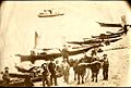
A photograph of American settlers and Native Americans on the beach in Mukilteo, c. 1861–62
-
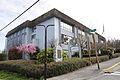
The former Rosehill School, constructed in 1928 and later converted into a community center before its demolition in 2010
-
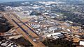
Aerial view of Paine Field, home to the Boeing Everett Factory
-
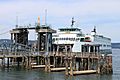
MV Kittitas at the former Mukilteo ferry terminal, which was replaced in 2020
-
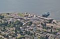
Aerial view of Mukilteo's downtown waterfront in 2019, featuring the former ferry terminal
-
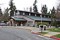
The Mukilteo public library, located in Harbour Pointe and operated by Sno-Isle Libraries
-
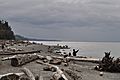
A coastal beach at Mukilteo Lighthouse Park


.jpg)


See also
 In Spanish: Mukilteo (Washington) para niños
