
Mullewa, Western Australia facts for kids
Quick facts for kids MullewaWestern Australia |
|
|---|---|
.jpg)
Jose Street, Mullewa, 2018
|
|

Mullewa
Location in Western Australia
|
|
| Population | 425 (2006 census) |
| Established | 1894 |
| Postcode(s) | 6630 |
| Elevation | 281 m (922 ft) |
| Location | |
| LGA(s) | City of Greater Geraldton |
| State electorate(s) | Moore |
| Federal Division(s) | Durack |
Mullewa is a town in the Mid West region of Western Australia, 450 kilometres (280 mi) north of Perth and 98 kilometres (61 mi) east-northeast of Geraldton. Mullewa is well known for an abundance of wildflowers in spring and it is one of the few places in Western Australia that the wreath flower grows. The surrounding areas produce wheat and other cereal crops. The town is a receival site for Cooperative Bulk Handling.
Contents
History
European settlers moved to the area in 1869 to take up pastoral leases for farming. In 1894, the government built a narrow gauge railway from Geraldton to Mullewa and the town was gazetted in the same year. The town is named for Mullewa Spring, based on an Aboriginal name recorded by surveyor John Forrest in 1873. The meaning of the name is not certain, but the most accepted meaning is "place of fog".
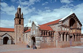
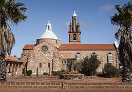
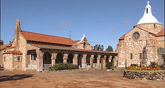
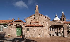
Church of Our Lady of Mt. Carmel and the Holy Apostles St. Peter and St. Paul and Priesthouse
The architect priest Mgr John Hawes built the Church mainly with his own hands and the help of parishioners. Work started in 1921 and the stone and tile church was completed, after some interruptions, in 1927. The eclectic design of the Church shows some influence of Spanish Mission style. Hawes built a presbytery for himself next to the church and this, known as the Priesthouse, was finished in 1929: it’s been used as a museum since 1980.
- Images of Our Lady of Mt. Carmel complex
-
The Church, front
-
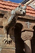
Gargoyle on the Church
-
Church, side view
-
Priesthouse and Church
-
Priesthouse, street view

.jpg)


Rail service
One of the Western Australian Government Railways named overnight passenger services from Perth was known as The Mullewa, which ceased operation in 1974. Mullewa is the junction of the railway line northeast to Meekatharra, and south to Northam.
Iron ore from the Tallering Peak mine is hauled by road 65 km to Mullewa, and loaded onto railway wagons for haulage 107 km to Geraldton where ships of up to 60,000 DWT are loaded.
Climate
Mullewa has a semi-arid climate with hot summers and mild to cool winters. The town features a dry summer/wetter winter routine, thus giving its climate some characteristics of the Mediterranean one.
| Climate data for Mullewa | |||||||||||||
|---|---|---|---|---|---|---|---|---|---|---|---|---|---|
| Month | Jan | Feb | Mar | Apr | May | Jun | Jul | Aug | Sep | Oct | Nov | Dec | Year |
| Record high °C (°F) | 47.3 (117.1) |
46.5 (115.7) |
44.0 (111.2) |
41.7 (107.1) |
35.5 (95.9) |
29.4 (84.9) |
28.9 (84.0) |
33.0 (91.4) |
37.6 (99.7) |
40.4 (104.7) |
43.2 (109.8) |
45.0 (113.0) |
47.3 (117.1) |
| Average high °C (°F) | 36.8 (98.2) |
36.4 (97.5) |
33.7 (92.7) |
28.7 (83.7) |
23.7 (74.7) |
19.9 (67.8) |
18.7 (65.7) |
20.1 (68.2) |
23.4 (74.1) |
27.1 (80.8) |
31.1 (88.0) |
34.4 (93.9) |
27.8 (82.0) |
| Average low °C (°F) | 19.4 (66.9) |
20.0 (68.0) |
18.3 (64.9) |
15.0 (59.0) |
11.1 (52.0) |
8.5 (47.3) |
6.9 (44.4) |
7.0 (44.6) |
8.5 (47.3) |
11.0 (51.8) |
14.3 (57.7) |
16.9 (62.4) |
13.1 (55.6) |
| Record low °C (°F) | 9.0 (48.2) |
10.0 (50.0) |
7.4 (45.3) |
5.0 (41.0) |
1.4 (34.5) |
−0.3 (31.5) |
−1.2 (29.8) |
−1.4 (29.5) |
0.0 (32.0) |
2.8 (37.0) |
6.0 (42.8) |
7.2 (45.0) |
−1.4 (29.5) |
| Average precipitation mm (inches) | 13.1 (0.52) |
18.6 (0.73) |
18.8 (0.74) |
21.2 (0.83) |
47.2 (1.86) |
64.6 (2.54) |
60.4 (2.38) |
42.2 (1.66) |
21.7 (0.85) |
13.0 (0.51) |
8.7 (0.34) |
8.5 (0.33) |
339.0 (13.35) |
| Average precipitation days | 2.3 | 2.4 | 2.5 | 3.8 | 7.1 | 10.3 | 11.2 | 9.6 | 6.1 | 4.1 | 2.3 | 1.9 | 63.6 |
